Waukon, Iowa
| Waukon, Iowa | |
|---|---|
| City | |
 Location of Waukon within County and State | |
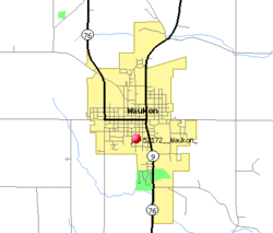 Detailed local map of Waukon | |
| Coordinates: 43°16′8″N 91°28′45″W / 43.26889°N 91.47917°WCoordinates: 43°16′8″N 91°28′45″W / 43.26889°N 91.47917°W | |
| Country |
|
| State |
|
| County | Allamakee |
| Township | Makee |
| Area[1] | |
| • Total | 2.82 sq mi (7.30 km2) |
| • Land | 2.82 sq mi (7.30 km2) |
| • Water | 0 sq mi (0 km2) |
| Elevation | 1,237 ft (377 m) |
| Population (2010)[2] | |
| • Total | 3,897 |
| • Estimate (2012[3]) | 3,871 |
| • Density | 1,381.9/sq mi (533.6/km2) |
| Time zone | Central (CST) (UTC-6) |
| • Summer (DST) | CDT (UTC-5) |
| ZIP code | 52172 |
| Area code(s) | 563 |
| FIPS code | 19-82740 |
| GNIS feature ID | 0462754 |
| Website | cityofwaukon.com |
Waukon is a city in Makee Township, Allamakee County, Iowa, United States, and the county seat of Allamakee County.[4] The population was 3,897 at the 2010 census. It is home to the annual Allamakee County Fair.
History
Waukon is often said to be named for Waukon Decorah,[5] a Ho Chunk (Winnebago) leader who was a U.S. ally during the 1832 Black Hawk War, although the city is also said to be named for his son Chief John Waukon.[6] Winnebagos lived in this area of Iowa in the 1840s, before being forced to relocate to Minnesota.
The first white settler arrived in 1849, and the town was founded and the Waukon Post Office opened in 1853.[7] A court house was completed in 1861, and the county seat was moved to Waukon in 1867 after 8 elections attempting to decide the location of the county seat.[8] The town was incorporated in 1883.[9]
Waukon is only about 16 miles from Waukon Junction, on the Mississippi River, but the rail line between these two points was 33 miles long, climbing 600 feet through some of the roughest terrain in Iowa.[10] The Waukon and Mississippi Railroad, which opened in 1877, was originally built as a narrow gauge line.[8] The line was originally controlled by the Chicago and Northwestern but was quickly acquired by the Chicago, Milwaukee and St. Paul Railway.[11] The line was widened to standard gauge after purchase by the Milwaukee Road. Its only marginal traffic through its existence led to the road's abandonment in the late 1960s.[12]
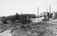
There is a deposit of limonite (Iron Ore) about 3 miles northeast of Waukon called Iron Hill, holding an estimated 10 million tons of ore. This is the highest point in northeastern Iowa. the Waukon Iron Company began developing an open-pit mine and ore-washing plant on this site in 1899, with a capacity of 300 tons per 10-hour shift. Production was seriously limited by the need to haul the ore 3 miles to the railroad, and the mine was, ultimately, a failure.[13]
A second and better capitalised attempt to mine this deposit was begun in 1907 by the Missouri Iron Company, with a railroad connection built in 1910 and a new ore processing plant completed in 1913 with a capacity of 350 to 400 tons per day.[14][15] The total investment was estimated at $225,000,[16] and two patents were issued for the machinery in the ore processing plant.[17][18] This mine became the principal mine of the new Mississippi Valley Iron Company of St. Louis, Missouri in 1916.[19]
That year, the mine produced 10,151 tons of concentrated ore, and in 1917, it produced 22,612 tons.[20] In 1918 the mine produced over 7000 tons before it was shut down because of World War I.[21]
The mine never recovered from this shutdown, and the equipment was sold for scrap in 1937.[22] Iron Mine Drive and Allamakee Street cross north of the sites of both old mines (43°17′53.62″N 91°27′35.85″W / 43.2982278°N 91.4599583°W).[23]
Geography
Waukon is located at 43°16′8″N 91°28′45″W / 43.26889°N 91.47917°W (43.268889, -91.479212).[24] The headwaters of the north branch of Paint Creek are in town, and the town is just south of the headwaters of Village Creek.[25] This is on the west edge of the deeply eroded Driftless Area of northwest Iowa.[10] The town sits on a plain underlain by the Galena Limestone formation. There are many sinkholes in this plain south of Waukon. To the north, a tongue of Galena Limestone underlies Iron Hill.[26]
According to the United States Census Bureau, the city has a total area of 2.82 square miles (7.30 km2), all of it land.[1]
Demographics
| Waukon historical population | ||
|---|---|---|
| Year | Pop. | ±% |
| 1880 | 1,350 | — |
| 1890 | 1,610 | +19.3% |
| 1900 | 2,153 | +33.7% |
| 1910 | 2,025 | −5.9% |
| 1920 | 2,359 | +16.5% |
| 1930 | 2,526 | +7.1% |
| 1940 | 2,972 | +17.7% |
| 1950 | 3,158 | +6.3% |
| 1960 | 3,639 | +15.2% |
| 1970 | 3,883 | +6.7% |
| 1980 | 3,983 | +2.6% |
| 1990 | 4,019 | +0.9% |
| 2000 | 4,131 | +2.8% |
| 2010 | 3,897 | −5.7% |
| 2014 | 3,795 | −2.6% |
| 2015 | 3,736 | −1.6% |
| Source: "American FactFinder". United States Census Bureau. Source: | ||
2010 census
As of the census[2] of 2010, there were 3,897 people, 1,781 households, and 1,008 families residing in the city. The population density was 1,381.9 inhabitants per square mile (533.6/km2). There were 1,946 housing units at an average density of 690.1 per square mile (266.4/km2). The racial makeup of the city was 98.4% White, 0.4% African American, 0.1% Native American, 0.1% Asian, 0.3% from other races, and 0.7% from two or more races. Hispanic or Latino of any race were 1.4% of the population.
There were 1,781 households of which 24.3% had children under the age of 18 living with them, 43.0% were married couples living together, 9.4% had a female householder with no husband present, 4.2% had a male householder with no wife present, and 43.4% were non-families. 37.5% of all households were made up of individuals and 18% had someone living alone who was 65 years of age or older. The average household size was 2.11 and the average family size was 2.77.
The median age in the city was 45.8 years. 20.4% of residents were under the age of 18; 7.9% were between the ages of 18 and 24; 20.7% were from 25 to 44; 27% were from 45 to 64; and 24% were 65 years of age or older. The gender makeup of the city was 46.6% male and 53.4% female.
2000 census
As of the census[28] of 2000, there were 4,131 people, 1,790 households, and 1,068 families residing in the city. The population density was 1,404.3 people per square mile (542.5/km²). There were 1,909 housing units at an average density of 649.0 per square mile (250.7/km²). The racial makeup of the city was 98.74% White, 0.10% Native American, 0.22% Asian, 0.02% Pacific Islander, 0.15% from other races, and 0.77% from two or more races. Hispanic or Latino of any race were 0.73% of the population.
There were 1,790 households out of which 26.6% had children under the age of 18 living with them, 47.5% were married couples living together, 9.4% had a female householder with no husband present, and 40.3% were non-families. 36.5% of all households were made up of individuals and 20.3% had someone living alone who was 65 years of age or older. The average household size was 2.21 and the average family size was 2.89.
Age spread: 22.8% under the age of 18, 7.6% from 18 to 24, 23.3% from 25 to 44, 21.7% from 45 to 64, and 24.6% who were 65 years of age or older. The median age was 42 years. For every 100 females there were 84.3 males. For every 100 females age 18 and over, there were 81.4 males.
The median income for a household in the city was $30,325, and the median income for a family was $41,068. Males had a median income of $27,532 versus $18,833 for females. The per capita income for the city was $17,047. About 8.3% of families and 12.3% of the population were below the poverty line, including 19.7% of those under age 18 and 6.8% of those age 65 or over.
Parks and recreation
Waukon Family Aquatic Area: The aquatic pool is the main attraction in Waukon's park. Also in the park is a small area with a lake, as well as some playgrounds. The park also includes some softball/athletic fields.
Education
Children in Waukon attend the schools of the Allamakee Community School District, which is headquartered in the city.[29]
School sports
The name for the sports teams of Waukon High School is Indians [29]
Media
Newspaper
Radio
Notable people
- Dudley W. Adams, horticulturalist who led the granger movement
- Mark Farley, head football coach of the University of Northern Iowa
- Levi M. Hubbell, politician and businessman[30]
- Hugh Kidder, officer in the United States Marine Corps during World War II
- Edward P. Ney, famous professor at the University of Minnesota
- Cletus F. O'Donnell, second Roman Catholic bishop of the Roman Catholic Diocese of Madison
- Joseph Taggart, member of the U.S House of Representatives
References
- 1 2 "US Gazetteer files 2010". United States Census Bureau. Retrieved 2012-05-11.
- 1 2 "American FactFinder". United States Census Bureau. Retrieved 2012-05-11.
- ↑ "Population Estimates". United States Census Bureau. Retrieved 2013-05-23.
- ↑ "Find a County". National Association of Counties. Retrieved 2011-06-07.
- ↑ Virgil J. Vogel, Indian names on Wisconsin's map (University of Wisconsin Press, 1991), 61.
- ↑ Val Swinton (August 16, 1994). "Winnebago tribe leaves Iowa legacy: Chief's descendant researches history". The Gazette (Cedar Rapids-Iowa City). Retrieved December 24, 2010.
- ↑ Waukon Post Office, in the USGS Geographic Names Information System
- 1 2 W. E. Alexander, Chapter XII- Chronology, History of Allamakee County, History of Winneshiek and Allamakee Counties, Iowa, Western, Sioux City, 1882; pages 463-464.
- ↑ Tom Savage, A Dictionary of Iowa Place Names, University of Iowa Press, 2007; page 231.
- 1 2 Samuel Calvin, What Glaciers have done for Iowa, Annual Report of the Iowa Weather and Crop Service, 1899 Conway, Des Moines, 1900; page 62.
- ↑ W. E. Alexander, Railroad History, Chapter VI, History of Winneshiek County, History of Winneshiek and Allamakee Counties, Iowa, Western, Sioux City, 1882; page 219.
- ↑ Rehder and Cook (December 1972). Grass Between The Rails. Waukon & Mississippi Press. Retrieved June 19, 2011.
- ↑ S.W. Beyer, Iowa's Iron Mine, The Iowa Engineer, Vol. 1, No. 4 (March 1902); pages 142-150. The article includes photos.
- ↑ Ellison Orr, Iron Hill, Chapter VIII -- Geology of Allamakee County, Past and Present of Allamakee County, Iowa, Vol. 1, Ellery M. Hancock, ed., S.J. Clarke, Chicago, 1913; pages 99-102.
- ↑ Jesse V. Howell, Treatment of the Ore, The Iron Ore Deposits Near Waukon Iowa, Annual Report, 1914, with Accompanying Papers, Iowa Geological Survey, Des Moines, 1916; pages 84-92. The photo of the plant on page 85 is noteworthy.
- ↑ Ernest Wander, The Goltra Process of Concentrating Iron Ores as Developed at Waukon, Iowa, Thesis, School of Mines and Metallurgy, University of Missouri, Rolla, 1917; page 49. The author of this thesis appears to have worked for both the Waukon Iron Company and the Missouri Iron Company.
- ↑ Robert W. Erwin, Apparatus for Treating Ores Preparatory to Magnetic Separation, U.S. Patent 1,295,719, Feb. 25, 1919.
- ↑ Edward F. Goltra, Thomas S. Maffitt, Jesse E. Dana, and Robert W. Erwin, Apparatus for Cleaning Clayey Ores, U.S. Patent 1,288,404, Dec. 17, 1918. The drawings in this patent closely match the actual layout of the mill buildings and therefore serve as an explanation of what was inside those buildings.
- ↑ Furnace Revival in St. Louis, The Iron Age, Vol. 97, No. 4 (January 27, 1916); page 281
- ↑ Ernest F. Burchard, Iron Ore, Pig Iron and Steel,Mineral Resources of the United States 1917, Part I Metals, H. D. McCaskey, ed., Government Printing Office, 1921; page 584.
- ↑ James H. Lees, Mineral Production in Iowa for 1917 and 1918, Annual Report, 1918, with Accompanying Papers, Iowa Geological Survey, Des Moines, 1922?; page 48.
- ↑ Writers' Program of the Works Progress Administration, Iowa -- A Guide to the Hawkeye State, Iowa State Historical Society, 1938; page 435.
- ↑ the former strip mines are visible in the USGS 1m resolution LIDAR image from Iowa Geographic Map Server
- ↑ "US Gazetteer files: 2010, 2000, and 1990". United States Census Bureau. 2011-02-12. Retrieved 2011-04-23.
- ↑ Samuel Calvin, Drainage, Geology of Allamakee County, Third Annual Report, 1894, Iowa Geological Survey, 1895; pages 50-51.
- ↑ Jesse V. Howell, The Galena Formation, The Iron Ores of Iron Hill Near Waukon Iowa, Annual Report with Accompanying Papers, 1914, Iowa Geological Survey, Des Moines, 1916; pages 50-51.
- ↑ "Census of Population and Housing". Census.gov. Retrieved June 4, 2015.
- ↑ "American FactFinder". United States Census Bureau. Retrieved 2008-01-31.
- 1 2 "Allamakee Community School District". Adv. Web Design. Retrieved March 9, 2011.
- ↑ 'Annals of Iowa,' Vol X, No. 1, 3rd Series, Notable Deaths, pg. 75
External links
| Wikimedia Commons has media related to Waukon, Iowa. |
- City of Waukon
- Waukon Chamber of Commerce
- KNEI/KHPP Radio
- City-Data Comprehensive Statistical Data and more about Waukon
- Allamakee History
Municipalities and communities of Allamakee County, Iowa, United States | ||
|---|---|---|
| Cities | ||
| Townships | ||
| Unincorporated communities | ||
| Footnotes | ‡This populated place also has portions in an adjacent county or counties | |