Whitewater Township, Cape Girardeau County, Missouri
| Whitewater Township | |
|---|---|
| Township | |
 | |
| Coordinates: 37°27′10″N 089°48′16″W / 37.45278°N 89.80444°WCoordinates: 37°27′10″N 089°48′16″W / 37.45278°N 89.80444°W | |
| Country | United States |
| State | Missouri |
| County | Cape Girardeau |
| Area | |
| • Total | 36.5 sq mi (94.54 km2) |
| • Land | 36.45 sq mi (94.41 km2) |
| • Water | 0.05 sq mi (0.13 km2) 0.14% |
| Elevation[1] | 443 ft (135 m) |
| Population (2000) | |
| • Total | 1,263 |
| • Density | 34.7/sq mi (13.4/km2) |
| FIPS code | 29-79630[2] |
| GNIS feature ID | 0766404 |
Whitewater Township is one of ten townships in Cape Girardeau County, Missouri, USA. As of the 2000 census, its population was 1,263.
History
Whitewater Township was founded in 1852.[3] The township took its name from the Whitewater River.[4]
Geography
Whitewater Township covers an area of 36.5 square miles (95 km2) and contains no incorporated settlements. It contains thirteen cemeteries: Baker, Estes, Gladish, Kurre, Mayfield, Miller, Old Caney Fork, Old Niswonger, Riehn, Schmidt, Snyder, Wilkinson and Wise.
The streams of Caney Fork, Crawford Creek, Dry Creek, Little Muddy Creek, Panther Creek, Sandy Branch and Wolf Creek run through this township.
References
- ↑ "US Board on Geographic Names". United States Geological Survey. 2007-10-25. Retrieved 2008-01-31.
- ↑ "American FactFinder". United States Census Bureau. Retrieved 2008-01-31.
- ↑ History of Southeast Missouri: A Narrative Account of Its Historical Progress, Its People and Its Principal Interests, Volume 1. Lewis Publishing Company. 1912. p. 163.
- ↑ "Cape Girardeau County Place Names, 1928–1945 (archived)". The State Historical Society of Missouri. Retrieved 10 September 2016.
External links
Municipalities and communities of Cape Girardeau County, Missouri, United States | ||
|---|---|---|
| Cities | 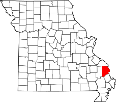 | |
| Villages | ||
| Townships | ||
| Unincorporated communities | ||
| Ghost towns | ||
| Footnotes | ‡This populated place also has portions in an adjacent county or counties | |
This article is issued from Wikipedia - version of the 10/20/2016. The text is available under the Creative Commons Attribution/Share Alike but additional terms may apply for the media files.