Jackson, Missouri
| Jackson, Missouri | |
|---|---|
| City | |
|
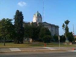
The Cape Girardeau County courthouse in Jackson, MO | |
 Location of Jackson, Missouri | |
| Coordinates: 37°22′48″N 89°39′29″W / 37.38000°N 89.65806°WCoordinates: 37°22′48″N 89°39′29″W / 37.38000°N 89.65806°W | |
| Country | United States |
| State | Missouri |
| County | Cape Girardeau |
| Area[1] | |
| • Total | 10.96 sq mi (28.39 km2) |
| • Land | 10.94 sq mi (28.33 km2) |
| • Water | 0.02 sq mi (0.05 km2) |
| Elevation | 463 ft (141 m) |
| Population (2010)[2] | |
| • Total | 13,758 |
| • Estimate (2012[3]) | 14,180 |
| • Density | 1,257.6/sq mi (485.6/km2) |
| Time zone | Central (CST) (UTC-6) |
| • Summer (DST) | CDT (UTC-5) |
| ZIP code | 63755 |
| Area code(s) | 573 |
| FIPS code | 29-35648[4] |
| GNIS feature ID | 0720202[5] |
Jackson is a city in Cape Girardeau County, Missouri, United States. The population was 13,758 at the 2010 census. It is the county seat of Cape Girardeau County.[6] It is a principal city of the Cape Girardeau–Jackson, MO-IL Metropolitan Statistical Area.
History
In 1813, Cape Girardeau County succeeded Cape Girardeau District, and the Court of Common Pleas and the Court of General Quarter-Sessions of the Peace in Cape Girardeau were superseded by the Court of Common Pleas, leading to a new seat of justice. The seat of the county and the courts were at first held on the plantation of Thomas Bull about one and one-half mile south of present-day Jackson. Land was then purchased along Hubble Creek for the county seat in 1814.
The first post office was established in 1814 when the area was called Birdstown.[7] The name was changed to Jackson on August 31, 1819, named for Andrew Jackson, a general popular for his role in the War of 1812.[8] It was the first town to be named after Andrew Jackson. The town was platted in 1815. The Missouri Herald, the third newspaper in state, was established here on June 25, 1819.[7] In 1818, the town already had a population of 300. The first county courthouse was built in 1818 on Jackson's public square.[9]
Although its initial growth was rapid, the economy of the City of Jackson developed conservatively. The town suffered a setback in June, 1833, when Cholera spread killing 128. Cholera struck again on June 10, 1852, causing all abled bodies to flee the town until the epidemic had run its course. [10] In 1841, a bank was established. A flour mill was constructed in 1855 and another in 1873. But the community could not escape the impact of the American Civil War; on June 24, 1861, a military skirmish took place near Jackson between units of the Union Army and the Confederate Army.
In 1877, Jackson was linked to Cape Girardeau by the first long-distance railway service line in Missouri. By 1884, the population of the City of Jackson had grown to 2,105, and the town supported 50 businesses. In 1884, by popular vote, it was decided to incorporate Jackson as a city of the fourth class. The courthouse built in 1818 burned down in 1870. The current courthouse was built in 1908 and is “on the square” in the center of Uptown Jackson where Jones Drug Store still runs and serves the community since 1871.[11]
The Big Hill Farmstead Historic District, Abraham Byrd House, Frizel-Welling House, Jackson Uptown Commercial Historic District, and McKendree Chapel are listed on the National Register of Historic Places.[12]
Geography
Jackson is located at 37°22′48″N 89°39′29″W / 37.38000°N 89.65806°W (37.379941, -89.658118).[13] According to the United States Census Bureau, the city has a total area of 10.96 square miles (28.39 km2), of which, 10.94 square miles (28.33 km2) is land and 0.02 square miles (0.05 km2) is water.[1]
Demographics
| Historical population | |||
|---|---|---|---|
| Census | Pop. | %± | |
| 1860 | 433 | — | |
| 1870 | 459 | 6.0% | |
| 1880 | 795 | 73.2% | |
| 1890 | 941 | 18.4% | |
| 1900 | 1,658 | 76.2% | |
| 1910 | 2,105 | 27.0% | |
| 1920 | 2,114 | 0.4% | |
| 1930 | 2,465 | 16.6% | |
| 1940 | 3,113 | 26.3% | |
| 1950 | 3,707 | 19.1% | |
| 1960 | 4,875 | 31.5% | |
| 1970 | 5,896 | 20.9% | |
| 1980 | 7,827 | 32.8% | |
| 1990 | 9,256 | 18.3% | |
| 2000 | 11,947 | 29.1% | |
| 2010 | 13,758 | 15.2% | |
| Est. 2015 | 14,869 | [14] | 8.1% |
2010 census
As of the census[2] of 2010, there were 13,758 people, 5,496 households, and 3,827 families residing in the city. The population density was 1,257.6 inhabitants per square mile (485.6/km2). There were 5,835 housing units at an average density of 533.4 per square mile (205.9/km2). The racial makeup of the city was 95.81% White, 1.65% Black or African American, 0.27% Native American, 0.57% Asian, 0.01% Native Hawaiian or Pacific Islander, 0.32% from other races, and 1.37% from two or more races. Hispanic or Latino of any race were 1.24% of the population.
There were 5,496 households of which 36.0% had children under the age of 18 living with them, 53.3% were married couples living together, 11.9% had a female householder with no husband present, 4.4% had a male householder with no wife present, and 30.4% were non-families. 26.4% of all households were made up of individuals and 11.3% had someone living alone who was 65 years of age or older. The average household size was 2.46 and the average family size was 2.96.
The median age in the city was 37.3 years. 25.6% of residents were under the age of 18; 8.3% were between the ages of 18 and 24; 26.1% were from 25 to 44; 24.8% were from 45 to 64; and 15.2% were 65 years of age or older. The gender makeup of the city was 47.0% male and 53.0% female.
2000 census
As of the census[4] of 2000, there were 11,947 people, 4,708 households, and 3,385 families residing in the city. The population density was 1,180.2 people per square mile (455.8/km²). There were 4,962 housing units at an average density of 490.2 per square mile (189.3/km²). The racial makeup of the city was 96.57% White, 1.36% African American, 0.28% Native American, 0.56% Asian, 0.03% Pacific Islander, 0.19% from other races, and 1.01% from two or more races. Hispanic or Latino of any race were 0.76% of the population.
There were 4,708 households out of which 36.9% had children under the age of 18 living with them, 59.2% were married couples living together, 9.9% had a female householder with no husband present, and 28.1% were non-families. 25.1% of all households were made up of individuals and 11.9% had someone living alone who was 65 years of age or older. The average household size was 2.50 and the average family size was 2.98.
In the city the population was spread out with 26.6% under the age of 18, 8.2% from 18 to 24, 29.9% from 25 to 44, 21.3% from 45 to 64, and 14.0% who were 65 years of age or older. The median age was 36 years. For every 100 females there were 89.8 males. For every 100 females age 18 and over, there were 85.8 males.
The median income for a household in the city was $40,412, and the median income for a family was $46,854. Males had a median income of $35,212 versus $19,994 for females. The per capita income for the city was $18,799. About 5.0% of families and 6.7% of the population were below the poverty line, including 6.7% of those under age 18 and 11.8% of those age 65 or over.
Government
Notable people
- Linda M. Godwin, NASA astronaut
- Gary Friedrich, writer of the comic book Ghost Rider
- Roy Thomas, writer (Marvel and DC Comics) and editor (Marvel). Writer of various movie scripts.
- Louis C. Wagner, Jr., United States Army four-star general
References
- 1 2 "US Gazetteer files 2010". United States Census Bureau. Archived from the original on January 24, 2012. Retrieved 2012-07-08.
- 1 2 "American FactFinder". United States Census Bureau. Retrieved 2012-07-08.
- ↑ "Population Estimates". United States Census Bureau. Archived from the original on June 17, 2013. Retrieved 2013-05-30.
- 1 2 "American FactFinder". United States Census Bureau. Archived from the original on September 11, 2013. Retrieved 2008-01-31.
- ↑ "US Board on Geographic Names". United States Geological Survey. 2007-10-25. Retrieved 2008-01-31.
- ↑ "Find a County". National Association of Counties. Archived from the original on May 31, 2011. Retrieved 2011-06-07.
- 1 2 "Anniversaries in 1949 of Events Recorded in The Missourian Files". Southeast Missouri. Cape Girardeau, Missouri. January 29, 1949.
- ↑ Eaton, David Wolfe (1916). How Missouri Counties, Towns and Streams Were Named. The State Historical Society of Missouri. p. 270.
- ↑ "10th Anniversary Edition: Celebrating Jackson's bicentennial". Southeast Missourian. April 10, 2015.
- ↑ "10th Anniversary Edition: The History of Jackson". Southeast Missourian. June 2, 2015.
- ↑ "Brief History of Jackson". jacksonmo.org. Retrieved 17 October 2014.
- ↑ National Park Service (2010-07-09). "National Register Information System". National Register of Historic Places. National Park Service.
- ↑ "US Gazetteer files: 2010, 2000, and 1990". United States Census Bureau. 2011-02-12. Retrieved 2011-04-23.
- ↑ "Annual Estimates of the Resident Population for Incorporated Places: April 1, 2010 to July 1, 2015". Retrieved July 2, 2016.
- ↑ "Census of Population and Housing". Census.gov. Archived from the original on May 11, 2015. Retrieved June 4, 2015.
External links
- The City of Jackson website
- Cape Girardeau
- Historic maps of Jackson in the Sanborn Maps of Missouri Collection at the University of Missouri
Municipalities and communities of Cape Girardeau County, Missouri, United States | ||
|---|---|---|
| Cities | 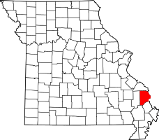 | |
| Villages | ||
| Townships | ||
| Unincorporated communities | ||
| Ghost towns | ||
| Footnotes | ‡This populated place also has portions in an adjacent county or counties | |