Wilmore, Kansas
| Wilmore, Kansas | |
|---|---|
| City | |
 Location within Comanche County and Kansas | |
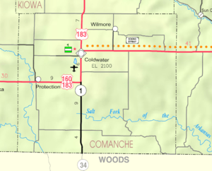 KDOT map of Comanche County (legend) | |
| Coordinates: 37°20′5″N 99°12′36″W / 37.33472°N 99.21000°WCoordinates: 37°20′5″N 99°12′36″W / 37.33472°N 99.21000°W | |
| Country | United States |
| State | Kansas |
| County | Comanche |
| Government | |
| • Type | Mayor–Council |
| Area[1] | |
| • Total | 0.20 sq mi (0.52 km2) |
| • Land | 0.20 sq mi (0.52 km2) |
| • Water | 0 sq mi (0 km2) |
| Elevation | 2,024 ft (617 m) |
| Population (2010)[2] | |
| • Total | 53 |
| • Estimate (2015)[3] | 52 |
| • Density | 270/sq mi (100/km2) |
| Time zone | Central (CST) (UTC-6) |
| • Summer (DST) | CDT (UTC-5) |
| ZIP code | 67155 |
| Area code(s) | 620 |
| FIPS code | 20-79550 [4] |
| GNIS feature ID | 0470741 [5] |
Wilmore is a city in Comanche County, Kansas, United States. As of the 2010 census, the city population was 53.[6]
History
Wilmore was founded in about 1887. It was named for Thomas Wilmore, the first merchant in town.[7][8]
The first post office in Wilmore was established on June 7, 1887.[9]
Geography
Wilmore is located at 37°20′5″N 99°12′36″W / 37.33472°N 99.21000°W (37.334642, -99.210123).[10] According to the United States Census Bureau, the city has a total area of 0.20 square miles (0.52 km2), all of it land.[1]
Climate
The climate in this area is characterized by hot, humid summers and generally mild to cool winters. According to the Köppen Climate Classification system, Wilmore has a humid subtropical climate, abbreviated "Cfa" on climate maps.[11]
Demographics
| Historical population | |||
|---|---|---|---|
| Census | Pop. | %± | |
| 1930 | 265 | — | |
| 1940 | 212 | −20.0% | |
| 1950 | 172 | −18.9% | |
| 1960 | 99 | −42.4% | |
| 1970 | 96 | −3.0% | |
| 1980 | 97 | 1.0% | |
| 1990 | 78 | −19.6% | |
| 2000 | 57 | −26.9% | |
| 2010 | 53 | −7.0% | |
| Est. 2015 | 52 | [3] | −1.9% |
| U.S. Decennial Census | |||
2010 census
As of the census[2] of 2010, there were 53 people, 27 households, and 19 families residing in the city. The population density was 265.0 inhabitants per square mile (102.3/km2). There were 34 housing units at an average density of 170.0 per square mile (65.6/km2). The racial makeup of the city was 100.0% White.
There were 27 households of which 11.1% had children under the age of 18 living with them, 66.7% were married couples living together, 3.7% had a male householder with no wife present, and 29.6% were non-families. 25.9% of all households were made up of individuals and 3.7% had someone living alone who was 65 years of age or older. The average household size was 1.96 and the average family size was 2.21.
The median age in the city was 54.4 years. 11.3% of residents were under the age of 18; 15.1% were between the ages of 18 and 24; 7.6% were from 25 to 44; 51% were from 45 to 64; and 15.1% were 65 years of age or older. The gender makeup of the city was 54.7% male and 45.3% female.
2000 census
As of the census[4] of 2000, there were 57 people, 30 households, and 20 families residing in the city. The population density was 279.4 people per square mile (110.0/km²). There were 41 housing units at an average density of 201.0 per square mile (79.2/km²). The racial makeup of the city was 100.00% White.
There were 30 households out of which 16.7% had children under the age of 18 living with them, 60.0% were married couples living together, and 33.3% were non-families. 33.3% of all households were made up of individuals and 16.7% had someone living alone who was 65 years of age or older. The average household size was 1.90 and the average family size was 2.35.
In the city the population was spread out with 14.0% under the age of 18, 14.0% from 25 to 44, 40.4% from 45 to 64, and 31.6% who were 65 years of age or older. The median age was 54 years. For every 100 females there were 111.1 males. For every 100 females age 18 and over, there were 104.2 males.
The median income for a household in the city was $16,786, and the median income for a family was $28,125. Males had a median income of $21,875 versus $13,750 for females. The per capita income for the city was $12,820. There were 25.0% of families and 27.1% of the population living below the poverty line, including no under eighteens and 31.6% of those over 64.
References
- 1 2 "US Gazetteer files 2010". United States Census Bureau. Retrieved 2012-07-06.
- 1 2 "American FactFinder". United States Census Bureau. Retrieved 2012-07-06.
- 1 2 "Annual Estimates of the Resident Population for Incorporated Places: April 1, 2010 to July 1, 2015". Retrieved July 2, 2016.
- 1 2 "American FactFinder". United States Census Bureau. Retrieved 2008-01-31.
- ↑ "US Board on Geographic Names". United States Geological Survey. 2007-10-25. Retrieved 2008-01-31.
- ↑ "2010 City Population and Housing Occupancy Status". U.S. Census Bureau. Retrieved July 4, 2011.
- ↑ Kansas State Historical Society (1916). Biennial Report of the Board of Directors of the Kansas State Historical Society. Kansas State Printing Plant. p. 167.
- ↑ "Profile for Wilmore, Kansas". ePodunk. Retrieved 7 June 2014.
- ↑ "Kansas Post Offices, 1828-1961". Kansas Historical Society. Retrieved 6 June 2014.
- ↑ "US Gazetteer files: 2010, 2000, and 1990". United States Census Bureau. 2011-02-12. Retrieved 2011-04-23.
- ↑ Climate Summary for Wilmore, Kansas
External links
- City
- Schools
- Comanche County USD 300, local school district
- Maps
- Wilmore City Map, KDOT
Municipalities and communities of Comanche County, Kansas, United States | ||
|---|---|---|
| Cities | 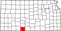 | |
| Unincorporated community | ||
| Townships | ||