Winchester, New Hampshire
| Winchester, New Hampshire | ||
|---|---|---|
| Town | ||
|
| ||
| ||
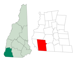 Location in Cheshire County, New Hampshire | ||
| Coordinates: 42°46′24″N 72°22′59″W / 42.77333°N 72.38306°WCoordinates: 42°46′24″N 72°22′59″W / 42.77333°N 72.38306°W | ||
| Country | United States | |
| State | New Hampshire | |
| County | Cheshire | |
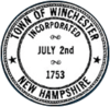
| Incorporated | 1753 | |
| Government | ||
| • Board of Selectmen |
Roberta Fraser, Chair Ben Kilanski Herbert C. Stephens Jack Marsh Ray Smith | |
| • Interim Town Administrator | Karey Miner | |
| Area | ||
| • Total | 55.5 sq mi (143.8 km2) | |
| • Land | 54.9 sq mi (142.3 km2) | |
| • Water | 0.6 sq mi (1.5 km2) 1.06% | |
| Elevation | 433 ft (132 m) | |
| Population (2010) | ||
| • Total | 4,341 | |
| • Density | 78/sq mi (30/km2) | |
| Time zone | Eastern (UTC-5) | |
| • Summer (DST) | Eastern (UTC-4) | |
| ZIP code | 03470 | |
| Area code(s) | 603 | |
| FIPS code | 33-85540 | |
| GNIS feature ID | 0873757 | |
| Website |
www | |
Winchester is a town in Cheshire County, New Hampshire, United States. The population was 4,341 at the 2010 census.[1] The primary settlement in the town, where 1,733 people resided at the 2010 census,[1] is defined by the U.S. Census Bureau as the Winchester census-designated place (CDP). The town also includes the village of Ashuelot and part of Pisgah State Park.
History

Originally named Arlington in honor of Charles Fitzroy, Earl of Arlington, this town was one of those established in 1733 by Colonial Governor Jonathan Belcher as protection for the Massachusetts border at the Connecticut River. After becoming a part of New Hampshire province in 1741, the town was granted to Colonel Josiah Willard, commander of Fort Dummer. In 1753, it was incorporated by Governor Benning Wentworth as Winchester, for Charles Paulet, 3rd Duke of Bolton, 8th Marquess of Winchester, and constable of the Tower of London.[2]
Pioneers who came to the town as early as 1732 were attacked many times by Indians. Several settlers were taken captive, and the town was burned in 1747. Its church, founded in 1736, is the oldest religious body in Cheshire County. The town has two covered bridges.
The Winchester Profession, an influential statement of the principles of Universalism, was adopted at a Universalist congress in Winchester in 1803.[3]
Although it has been an agricultural town, many small industries have been established in Winchester. In the 1830s, Graves & Company was among the nation's first manufacturers of musical instruments. The coming of the Ashuelot Railroad in 1850 fostered the growth of textile mills and wooden-ware factories, especially box manufacture and leather tanning.[4]
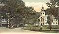 The Common c. 1905
 Conant Library in 1909
 Iron bridge c. 1910
Geography
According to the United States Census Bureau, the town has a total area of 55.5 square miles (144 km2), of which 54.9 square miles (142 km2) is land and 0.6 square miles (1.6 km2) is water, comprising 1.06% of the town. Winchester is drained by the Ashuelot River and Roaring Brook. Pisgah Reservoir and Kilburn Pond are in the northwest. The highest point in Winchester is 1,424-foot (434 m) Franklin Mountain, near the town's northeast corner.
The town center, defined as a census-designated place (CDP), covers an area of 3.0 square miles (7.8 km2), about 5.4% of the area of the town.
Winchester is served by state routes 10, 78 and 119.
Demographics
| Historical population | |||
|---|---|---|---|
| Census | Pop. | %± | |
| 1790 | 1,209 | — | |
| 1800 | 1,413 | 16.9% | |
| 1810 | 1,478 | 4.6% | |
| 1820 | 1,849 | 25.1% | |
| 1830 | 2,051 | 10.9% | |
| 1840 | 2,065 | 0.7% | |
| 1850 | 3,296 | 59.6% | |
| 1860 | 2,225 | −32.5% | |
| 1870 | 2,097 | −5.8% | |
| 1880 | 2,444 | 16.5% | |
| 1890 | 2,584 | 5.7% | |
| 1900 | 2,274 | −12.0% | |
| 1910 | 2,282 | 0.4% | |
| 1920 | 2,267 | −0.7% | |
| 1930 | 2,183 | −3.7% | |
| 1940 | 2,275 | 4.2% | |
| 1950 | 2,388 | 5.0% | |
| 1960 | 2,411 | 1.0% | |
| 1970 | 2,869 | 19.0% | |
| 1980 | 3,465 | 20.8% | |
| 1990 | 4,038 | 16.5% | |
| 2000 | 4,144 | 2.6% | |
| 2010 | 4,341 | 4.8% | |
| Est. 2015 | 4,213 | [5] | −2.9% |
As of the census of 2000, there were 4,144 people, 1,557 households, and 1,094 families residing in the town. The population density was 75.4 people per square mile (29.1/km²). There were 1,741 housing units at an average density of 12.2 persons/km² (31.7 persons/sq mi). The racial makeup of the town was 97.37% White, 0.31% African American, 0.56% Native American, 0.31% Asian, 0.00% Pacific Islander, 0.22% from other races, and 1.23% from two or more races. 0.82% of the population were Hispanic or Latino of any race.
There were 1,557 households out of which 33.5% had children under the age of 18 living with them, 52.9% were married couples living together, 11.9% have a woman whose husband does not live with her, and 29.7% were non-families. 23.3% of all households were made up of individuals and 10.3% had someone living alone who was 65 years of age or older. The average household size was 2.61 and the average family size was 3.03.
In the town the population was spread out with 25.5% under the age of 18, 7.6% from 18 to 24, 29.2% from 25 to 44, 23.5% from 45 to 64, and 14.2% who were 65 years of age or older. The median age was 37 years. For every 100 females there were 96.8 males. For every 100 females age 18 and over, there were 95.4 males.
The median income for a household in the town was $37,364, and the median income for a family was $43,393. Males had a median income of $30,399 versus $20,682 for females. The per capita income for the town was $16,012. 12.0% of the population and 10.0% of families were below the poverty line. Out of the total people living in poverty, 17.6% are under the age of 18 and 5.8% are 65 or older.
Town center
As of the census of 2000, there were 1,832 people, 690 households, and 467 families residing in the CDP (census-designated place) at the town center. The population density was 615.7 people per square mile (237.4/km²). There were 727 housing units at an average density of 94.2 persons/km² (244.3 persons/sq mi). The racial makeup of the town was 96.94% White, 0.49% African American, 0.66% Native American, 0.38% Asian, 0.22% from other races, and 1.31% from two or more races. 1.20% of the population were Hispanic or Latino of any race.
There were 690 households out of which 36.2% had children under the age of 18 living with them, 47.4% were married couples living together, 15.1% have a woman whose husband does not live with her, and 32.3% were non-families. 26.1% of all households were made up of individuals and 13.0% had someone living alone who was 65 years of age or older. The average household size was 2.63 and the average family size was 3.12.
In the CDP the population was spread out with 28.8% under the age of 18, 9.0% from 18 to 24, 29.9% from 25 to 44, 20.2% from 45 to 64, and 12.2% who were 65 years of age or older. The median age was 34 years. For every 100 females there were 94.9 males. For every 100 females age 18 and over, there were 93.3 males.
The median income for a household is $31,281, and the median income for a family was $39,828. Males had a median income of $29,909 versus $19,976 for females. The per capita income for the town was $13,646. 17.8% of the population and 17.3% of families were below the poverty line. Out of the total people living in poverty, 25.1% are under the age of 18 and 9.5% are 65 or older.
Culture
Since 1998, Winchester has held its annual Pickle Festival each September on its Main Street.
Sites of interest
- Ashuelot Covered Bridge
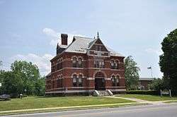
- Conant Library Museum
- Sheridan House (1870), the Winchester Historical Society Museum
- Monadnock Speedway
Notable people
- Henry Ashley, US congressman
- Michael Dubruiel, religious author
- Louis B. Goodall, industrialist, banker and US congressman
- Marshall Jewell, 25th US Postmaster General; 44th and 46th governor of Connecticut
- Addison Pratt, missionary
- Leonard Wood, US Army chief of staff
References
| Wikimedia Commons has media related to Winchester, New Hampshire. |
- 1 2 United States Census Bureau, American FactFinder, 2010 Census figures. Retrieved March 23, 2011.
- ↑ Coolidge, Austin J.; John B. Mansfield (1859). A History and Description of New England. Boston, Massachusetts. pp. 699–700.
- ↑ "Winchester Profession". Unitarian Universalist History and Heritage Society. Retrieved October 11, 2011.
- ↑ History of Winchester, Cheshire County, New Hampshire
- ↑ "Annual Estimates of the Resident Population for Incorporated Places: April 1, 2010 to July 1, 2015". Retrieved July 2, 2016.
- ↑ "Census of Population and Housing". Census.gov. Retrieved June 4, 2016.
External links
- Town website
- Conant Public Library
- New Hampshire Economic and Labor Market Information Bureau Profile
- Pisgah State Park
- Winchester Trailriders Snowmobile Club
Municipalities and communities of Cheshire County, New Hampshire, United States | ||
|---|---|---|
| City | 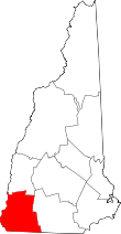 | |
| Towns | ||
| CDPs | ||
| Other villages | ||