Yakushima
| Native name: <span class="nickname" ">Japanese: 屋久島 | |
|---|---|
|
Landsat image of Yakushima | |
 Yakushima Location in Japan (with southern islands in inset) | |
| Geography | |
| Location | East China Sea |
| Coordinates | 30°21′31″N 130°31′43″E / 30.35861°N 130.52861°ECoordinates: 30°21′31″N 130°31′43″E / 30.35861°N 130.52861°E |
| Archipelago | Osumi Islands |
| Area | 504.88 km2 (194.94 sq mi) |
| Highest elevation | 1,935 m (6,348 ft) |
| Highest point | Miyanouradake |
| Administration | |
|
Japan | |
| Kagoshima Prefecture | |
| Demographics | |
| Population | 13,178 (2010) |
| Pop. density | 26.1 /km2 (67.6 /sq mi) |
| Ethnic groups | Japanese |
| Type | Natural |
| Criteria | vii, ix |
| Designated | 1993 (17th session) |
| Reference no. | 662 |
| State Party | Japan |
| Region | Asia-Pacific |
Yakushima (屋久島) is one of the Ōsumi Islands belonging to Kagoshima Prefecture, Japan. The island, 504.88 km² in area, has a population of 13,178. Access to the island is by hydrofoil ferry (7 or 8 times a day from Kagoshima, depending on the season), slow car ferry (once or twice a day from Kagoshima), or by air to Yakushima Airport (3 to 5 times daily from Kagoshima, once daily from Fukuoka and once daily from Osaka). Administratively, the whole island is the town of Yakushima. The town also serves neighbouring Kuchinoerabujima. The majority of the island is within the borders of the Kirishima-Yaku National Park.[1]
Yakushima's electricity is more than 50% hydroelectric, and surplus power has been used to produce hydrogen gas in an experiment by Kagoshima University. The island has been a test site for Honda's hydrogen fuel cell vehicle research. (There are no hydrogen cars stationed on the island but electric cars are run by the municipality.)
World Heritage designation
In 1980 an area of 18,958 ha was designated a UNESCO Man and the Biosphere Reserve.[2] In 1993, 10 hectares of wetland at Nagata-hama was designated a Ramsar Site.[3] It is the largest nesting ground for the endangered loggerhead sea turtle in the North Pacific.[1][4] Yakushima's unique remnant of warm/temperate ancient forest has been a natural World Heritage Site since 1993. In the Wilderness core area (12.19 square kilometres (3,010 acres)) of the World Heritage Site, no record of past tree cutting can be traced.[5] The island is visited by 300,000 tourists every year.
Geography
Yakushima is located approximately 61.3 kilometres (38.1 mi) south of the southern tip of Osumi Peninsula in southern Kyushu, or 135 kilometres (73 nmi) south of Kagoshima. The Vincennes Strait (Yakushima Kaikyō) separates it from the nearby island of Tanegashima, which is home to the Japanese Space Centre. Periodic rocket launches from Tanegashima can clearly be seen from Yakushima.
The bedrock of the island is granite, and as such it hosts no active volcanoes.[6] It has an area of approximately 504.5 square kilometres (194.8 sq mi). The island is roughly circular in shape, with a circumference of 89 kilometres (55 mi) and a diameter of 28 kilometres (17 mi). The highest elevations on the island are Miyanouradake (宮之浦岳), with a height of 1,935 metres (6,348 ft), and Nagatadake (永田岳), with a height of 1,886 metres (6,188 ft) above sea level; however, Yakushima has another 30 peaks of over 1,000 metres (3,300 ft) in height. There are numerous hot springs on the island.
History
Yakushima has been settled since at least the Jomon period. It is first mentioned in written documents of the Chinese Sui Dynasty of the 6th century, and in the Japanese Shoku Nihongi in an entry dated 702. It formed part of ancient Tane Province. It was often mentioned in the diaries of travellers between Tang Dynasty China and Nara period Japan. During the Edo period, Yakushima was ruled by the Shimazu clan of the Satsuma Domain and was considered part of Ōsumi Province. Following the Meiji restoration, the island has been administered as part of Kagoshima Prefecture.
Demographics and economics
The population of Yakushima reached a peak in 1960 with 24,010 inhabitants. It thereafter declined until about 1995, but has subsequently stabilised at just over 13,000 inhabitants.
Traditionally, the economic mainstays of the population were forestry and the export of wood products (principally cedar roof shingles), and commercial fishing. Cultivation of oranges and tea, the distilling of shōchū, and tourism are now the main sources of income.
Flora and fauna
The only large animals indigenous to the island are red-bottomed macaques (Yakushima macaque) and a variety of sika deer (yakushika). The tanuki is also a common animal, but is not native to the island. Japanese weasels (Mustela itatsi) may also be seen from time to time. The island is a spawning ground for migratory loggerhead turtles, and dolphins are to be found offshore. The coastal areas have coral reefs in places, although to a much lesser extent than are found farther south in the islands of Okinawa.
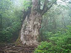
Yakushima is famous for its lush vegetation. Most of the island has at one time or another been logged (dating back at least to the early Edo period), but has been extensively replanted and reseeded since logging ended in the late 1960s, at which time a conservation regime was established. In addition to this secondary forest, there are some remaining areas of primary forest, composed mainly of a variety of Cryptomeria japonica, or Japanese cedar, known as yakusugi (屋久杉), the best known single example of which is named the Jomon Sugi (縄文杉), as its age is estimated to date to at least the Jomon period of Japanese history, 2300 years ago. In addition, the island lists over 50 varieties of endemic flower, notably rhododendrons, and hundreds of rare endemic Bryophyta, as well as a number of endemic trees.
Climate
Yakushima has a humid subtropical climate (Köppen climate classification Cfa) with hot, humid summers and mild winters. Precipitation is extremely heavy, with at least 250 millimetres (9.8 in) in each month and as much as 773 millimetres (30.4 in) in June alone. Yakushima is Japan's wettest place,[7] and annual precipitation in Yakushima is one of the world's highest at 4,000 to 10,000 mm. It is said by the locals to rain "35 days a month". There are drier periods in autumn and winter, while the heaviest downpours occur in spring and summer, often accompanied by landslides. It is the southernmost place in Japan where there is snow in the mountains, often for months, while the ocean temperature is never below 19 °C.
| Climate data for Yakushima | |||||||||||||
|---|---|---|---|---|---|---|---|---|---|---|---|---|---|
| Month | Jan | Feb | Mar | Apr | May | Jun | Jul | Aug | Sep | Oct | Nov | Dec | Year |
| Record high °C (°F) | 25.3 (77.5) |
26.1 (79) |
29.6 (85.3) |
29.8 (85.6) |
31.9 (89.4) |
34.8 (94.6) |
35.2 (95.4) |
35.4 (95.7) |
34.7 (94.5) |
31.0 (87.8) |
30.7 (87.3) |
25.7 (78.3) |
35.4 (95.7) |
| Average high °C (°F) | 14.4 (57.9) |
15.2 (59.4) |
17.5 (63.5) |
21.1 (70) |
24.3 (75.7) |
26.8 (80.2) |
30.4 (86.7) |
30.6 (87.1) |
28.7 (83.7) |
24.9 (76.8) |
20.9 (69.6) |
16.6 (61.9) |
22.62 (72.71) |
| Daily mean °C (°F) | 11.6 (52.9) |
12.1 (53.8) |
14.3 (57.7) |
17.7 (63.9) |
20.8 (69.4) |
23.6 (74.5) |
26.9 (80.4) |
27.2 (81) |
25.5 (77.9) |
21.9 (71.4) |
17.9 (64.2) |
13.6 (56.5) |
19.43 (66.97) |
| Average low °C (°F) | 8.7 (47.7) |
9.1 (48.4) |
11.1 (52) |
14.2 (57.6) |
17.3 (63.1) |
20.7 (69.3) |
23.7 (74.7) |
24.2 (75.6) |
22.6 (72.7) |
19.0 (66.2) |
14.9 (58.8) |
10.6 (51.1) |
16.34 (61.43) |
| Record low °C (°F) | 1.1 (34) |
0.7 (33.3) |
1.5 (34.7) |
4.5 (40.1) |
9.3 (48.7) |
13.7 (56.7) |
18.3 (64.9) |
19.6 (67.3) |
15.2 (59.4) |
9.1 (48.4) |
5.6 (42.1) |
2.2 (36) |
0.7 (33.3) |
| Average rainfall mm (inches) | 272.9 (10.744) |
286.7 (11.287) |
428.1 (16.854) |
421.7 (16.602) |
441.0 (17.362) |
773.6 (30.457) |
311.9 (12.28) |
269.0 (10.591) |
406.1 (15.988) |
299.6 (11.795) |
303.9 (11.965) |
262.7 (10.343) |
4,477.2 (176.268) |
| Average rainy days (≥ 0.5 mm) | 17.4 | 15.1 | 17.9 | 14.2 | 14.1 | 18.0 | 12.1 | 14.7 | 14.5 | 12.5 | 13.1 | 15.0 | 178.6 |
| Average relative humidity (%) | 68 | 68 | 71 | 72 | 76 | 83 | 82 | 81 | 79 | 73 | 70 | 68 | 74.3 |
| Mean monthly sunshine hours | 73.7 | 79.1 | 107.0 | 137.9 | 151.8 | 115.8 | 220.8 | 201.3 | 145.0 | 119.9 | 96.0 | 84.2 | 1,532.5 |
| Source #1: 平年値(年・月ごとの値) | |||||||||||||
| Source #2: 観測史上1~10位の値(7月としての値) (records) | |||||||||||||
Pollution
The island is downwind of heavily polluted areas in the People's Republic of China. Yakushima white pine in the forest on the island may have been affected by combustion products from coal burning and automobile exhaust.[8]
In popular culture
The forests of Yakushima inspired the forest setting in Hayao Miyazaki's film Princess Mononoke.[9]
Yakushima is the inspiration behind the forest of Dremuchij in Metal Gear Solid 3: Snake Eater.[10]
See also
- Ernest Henry Wilson - Wilson stump
- List of Special Places of Scenic Beauty, Special Historic Sites and Special Natural Monuments
- List of World Heritage Sites in Japan
- List of national parks of Japan
- Ramsar sites in Japan
References
- Witham, Clive. Yakushima: A Yakumonkey Guide. Siesta Press. (2009) ISBN 0956150705
External links
| Wikimedia Commons has media related to Yakushima. |
| Wikivoyage has a travel guide for Yakushima. |
Notes
- 1 2 "Introducing places of interest: Kirishima-Yaku National Park". Ministry of the Environment. Retrieved 24 March 2011.
- ↑ "Biosphere Reserve Information - Yakushima". UNESCO. Retrieved 29 April 2011.
- ↑ "Ramsar Sites in Japan - Yakushima Nagata-hama" (PDF). Ministry of the Environment. Retrieved 24 March 2011.
- ↑ "Kirishima-Yaku National Park". Natural Parks Foundation. Retrieved 24 March 2011.
- ↑ "World Heritage Nomination - IUCN Summary" (PDF). UNESCO World Heritage Committee. Retrieved 2008-08-28.
- ↑ http://www.jnto.go.jp/eng/indepth/scenic/worldheritage/c_12_yakushima.html
- ↑ http://www.climate-charts.com/Countries/Japan.html
- ↑ Martin Fackler (April 24, 2013). "Scientist Says Pollution From China Is Killing a Japanese Island's Trees". The New York Times. Retrieved April 25, 2013.
- ↑ "World Heritage - Yakushima". Japan Airlines. Retrieved 2008-08-15.
- ↑ , Hideo Kojima offers insight and commentary on Metal Gear Solid 3: Snake Eater.