Yantian District
| Yantian 盐田区 | |
|---|---|
| District | |
|
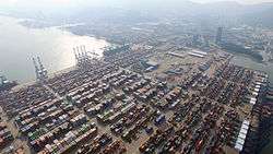
Yantian Port | |
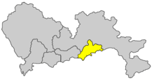 Yantian District in Shenzhen | |
| Country | China |
| Province | Guangdong |
| Prefecture | Shenzhen |
| Area | |
| • Total | 72.63 km2 (28.04 sq mi) |
| Population (2006) | |
| • Total | 218,700 |
| • Density | 3,000/km2 (7,800/sq mi) |
| Time zone | China Standard (UTC+8) |
| Area code(s) | 0755 |
| Website | www.yantian.gov.cn |
Yantian District (simplified Chinese: 盐田区; traditional Chinese: 鹽田區; pinyin: Yántián Qū; Cantonese Jyutping: Jim4 Tin4 Keoi1) is one of the six districts of the city of Shenzhen, Guangdong, China. It is adjacent to Shenzhen River to the south, and is surrounded by Luohu and Longgang districts of Shenzhen. Until March 1998, Yantian was part of Luohu District.
Subdistricts
The size of Yantian district is about 72.63 km². It contains four subdistricts:
| Name | Chinese (S) | Hanyu Pinyin | Canton Romanization | Population (2010)[1] | Area (km2) |
|---|---|---|---|---|---|
| Haishan Subdistrict | 海山街道 | Hǎishān Jiēdào | hoi2 san1 gai1 dou6 | 61,858 | 5.52 |
| Yantian Subdistrict | 盐田街道 | Yántián Jiēdào | yim4 tin4 gai1 dou6 | 80,641 | 17.8 |
| Meisha Subdistrict | 梅沙街道 | Méishā Jiēdào | mui4 sa1 gai1 dou6 | 18,063 | 16.83 |
| Shatoujiao Subdistrict | 沙头角街道 | Shātóujiǎo Jiēdào | sa1 teo4 gog3 gai1 dou6 | 48,798 | 6.91 |
Located on Mirs Bay, Yantian is the location of some of Shenzhen's best-known tourist beaches, Dameisha and Xiaomeisha. Yantian Port is also located within the district.[2]
Economy
Industrial zone
The Shenzhen Yantian Port Free Trade Zone was set up and approved by the State Council on September 27, 1996 with a total area of 0.85 square kilometer. On August 16, 2004, the project of "zone-port interaction" was approved by the State Council between Yantian Port and the Shenzhen Yantiangang Free Trade Zone.
Yantian Port Bonded Logistics Park was established with 0.96 square kilometer on December 30, 2005. The zone is situated near Yantian Port. Industries that are encouraged include printing/publishing/packaging, raw material processing, shipping/warehousing/logistics, and trading and distribution.[3]
Tourist attractions
- Minsk World(明斯克世界)
- Chung Ying Street(中英街)
- Wutongshan National Park (梧桐山國家森林公園/梧桐山国家森林公园)
- Dameisha Beach (大梅沙)
- Xiaomeisha Beach (小梅沙)
- Shenzhen Xiaomeisha Sea World[4](小梅沙海洋世界)
- OCT East[5](東部華僑城/东部华侨城)
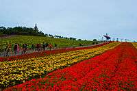 Flower Field in OCT East
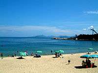 Xiaomeisha Beach
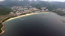 Dameisha beach
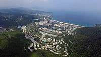 Dameisha as viewed from OCT East
Transportation
The proposed Shenzhen Metro Yantian Line will be built to help serve the area.
References
- ↑ shi, Guo wu yuan ren kou pu cha ban gong; council, Guo jia tong ji ju ren kou he jiu ye tong ji si bian = Tabulation on the 2010 population census of the people's republic of China by township / compiled by Population census office under the state; population, Department of; statistics, employment statistics national bureau of (2012). Zhongguo 2010 nian ren kou pu cha fen xiang, zhen, jie dao zi liao (Di 1 ban. ed.). Beijing Shi: Zhongguo tong ji chu ban she. ISBN 978-7-5037-6660-2.
- ↑ http://www.yantian-port.com/index.htm
- ↑ RightSite.asia | Shenzhen Yantiangang Free Trade Zone
- ↑ http://www.szxms.com.cn/
- ↑ http://en.octeast.com/about/
External links
| Wikimedia Commons has media related to Yantian District. |
- Yantian Government Online (Chinese)
| Sub-provincial cities |
| ||||||||||||||||||||||||||||||||||||||||||||||||||||||||||||||||||||||||||||||||||||||||||||||
|---|---|---|---|---|---|---|---|---|---|---|---|---|---|---|---|---|---|---|---|---|---|---|---|---|---|---|---|---|---|---|---|---|---|---|---|---|---|---|---|---|---|---|---|---|---|---|---|---|---|---|---|---|---|---|---|---|---|---|---|---|---|---|---|---|---|---|---|---|---|---|---|---|---|---|---|---|---|---|---|---|---|---|---|---|---|---|---|---|---|---|---|---|---|---|---|
| Prefecture-level cities |
| ||||||||||||||||||||||||||||||||||||||||||||||||||||||||||||||||||||||||||||||||||||||||||||||
| |||||||||||||||||||||||||||||||||||||||||||||||||||||||||||||||||||||||||||||||||||||||||||||||
Coordinates: 22°33′49″N 114°14′24″E / 22.5637°N 114.24°E