Southern Yatsugatake Volcanic Group
| Southern Yatsugatake Volcanic Group | |
|---|---|
| 南八ヶ岳 Minami-Yatsugatake | |
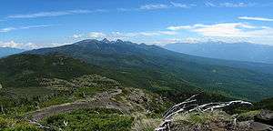
 Yatsugatake from Mount Gongen (August 2010) | |
| Highest point | |
| Peak | Mount Aka |
| Elevation | 2,899 m (9,511 ft) |
| Coordinates | 35°58′15″N 138°22′12″E / 35.97083°N 138.37000°ECoordinates: 35°58′15″N 138°22′12″E / 35.97083°N 138.37000°E |
| Naming | |
| Etymology | Southern mountains with eight peaks |
| Geography | |
| Country | Japan |
| States | Nagano Prefecture and Yamanashi Prefecture |
| Region | Chūbu |
| Districts | Minamisaku and Suwa |
| Parent range | Yatsugatake Mountains |
| Borders on | Northern Yatsugatake Volcanic Group |
| Biome | Alpine climate |
| Geology | |
| Orogeny | Island arc |
| Age of rock | Quaternary |
| Type of rock | Volcanic |
Southern Yatsugatake Volcanic Group (南八ヶ岳 Minami-Yatsugatake), also just Yatsugatake is a volcanic group of inactive volcanoes located on the border of Nagano Prefecture and Yamanashi Prefecture on Honshū in Japan.
Description
The Southern Yatsugatake Volcanic Group is part of the Yatsugatake Mountains. The southern group is defined as the mountains south of the Natsuzawa Pass. The highest peak of the mountains is Mount Aka and the elevation is 2,899 metres.
The southern Yatugatake mountains are steep and have alpine characteristics. The mountains of the Northern Yatsugatake Volcanic Group are gentler and lower.
This volcanic group is listed among the 100 famous mountains in Japan. There the mountains are listed as Yatsugatake. Mount Tateshina is also part of the Yatsugatake mountains, but is listed separately.
These mountains are part of the Yatsugatake-Chūshin Kōgen Quasi-National Park.[1]
Geology
The volcanoes are stratovolcanoes that are 1 million to 200,000 years old. The rock is mainly basalt and andesite.[2]
List of peaks
The following peaks make up the Southern Yatsugatake Volcanic Group:[2][3]
| Name | Height |
|---|---|
| Mount Aka (赤岳 Aka-dake) | 2,899.2 metres (9,511.8 ft) |
| Mount Yoko (横岳 Yoko-dake) | 2,829 metres (9,281 ft) |
| Mount Amida (阿弥陀岳 Amida-dake) | 2,805 metres (9,203 ft) |
| Mount Iō (硫黄岳 Iō-dake) | 2,760 metres (9,060 ft) |
| Mount Gongen (権現岳 Gongen-dake) | 2,715 metres (8,907 ft) |
| Mount Amigasa (編笠山 Amigasa-yama) | 2,523.7 metres (8,279.9 ft) |
| Mount Nishi (西岳 Nishi-dake) | 2,398 metres (7,867 ft) |
| Utsukushimori (美し森 Utsukushi-mori) | 1,542.4 metres (5,060.4 ft) |
Gallery
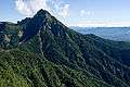 Mount Aka, the highest peak of the Yatsugatake mountains
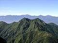 Mount Gongen, from Mount Aka
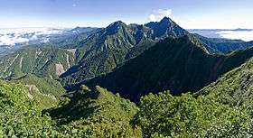
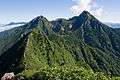 Mount Amida, Mount Iō, Mount Yoko and Mount Aka from Mount Gongen
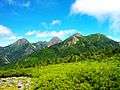 Mount Amida, Mount Iō, Mount Yoko, Mount Aka and Mount Gongen from Mount Amigasa
References
- ↑ 八ヶ岳中信高原国定公園. Japan Integrated Biodiversity Information System (in Japanese). Ministry of the Environment, Government of Japan. Retrieved 2008-09-05.
- 1 2 "YATSU-GA-TAKE". Quaternary Volcanoes of Japan. Geological Survey of Japan, AIST. 2006. Retrieved 2008-08-19.
- ↑ Hunt, Paul (1988). "14. Yatsu-ga-take". Hiking in Japan: An Adventurer's Guide to the Mountain Trails (First ed.). Tokyo: Kondansha International. pp. 111–115. ISBN 0-87011-893-5.
See also
| Wikimedia Commons has media related to Mount Yatsugatake. |
- Yatsugatake-Chūshin Kōgen Quasi-National Park
- Yatsugatake Mountains - Northern Yatsugatake Volcanic Group
- List of mountains in Japan