Yorkville, Illinois
| Yorkville, Illinois | |
| City | |
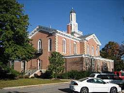 The Kendall County Courthouse is listed on the U.S. National Register of Historic Places. | |
| Official name: United City of Yorkville | |
| Motto: "The City With A River In Its Heart"[1] | |
| Nickname: The Ville, Y-Town, | |
| Country | United States |
|---|---|
| State | Illinois |
| County | Kendall |
| Townships | Bristol · Kendall |
| Elevation | 640 ft (195 m) |
| Coordinates | 41°39′57″N 88°26′31″W / 41.66583°N 88.44194°WCoordinates: 41°39′57″N 88°26′31″W / 41.66583°N 88.44194°W |
| Area | 20.05 sq mi (52 km2) |
| - land | 19.97 sq mi (52 km2) |
| - water | 0.09 sq mi (0 km2) |
| Population | 16,717 (July 2009) |
| Density | 878.8/sq mi (339/km2) |
| Founded | 1833 |
| - Incorporated | 1836 |
| Government | Mayor-council |
| Mayor | Gary J. Golinski |
| Timezone | CST (UTC-6) |
| - summer (DST) | CDT (UTC-5) |
| ZIP code | 60560 |
| Area codes | 630 / 331 |
  Location of Yorkville within Illinois | |
| Wikimedia Commons: Yorkville, Illinois | |
| Website: www.yorkville.il.us | |
| [2][3][4] | |
Yorkville (Official name: United City of Yorkville) is a city located in Kendall County, Illinois, United States. The population was 6,189 at the 2000 United States Census and had grown to 16,921 as of the 2010 census.[5] It is the county seat of Kendall County.[6] Yorkville is located in the center of Kendall County, the fastest-growing county in Illinois and according to recent statistics released in June 2010, by CNN, is the fastest-growing county in the United States.[4]
History

In 1836, the village of Yorkville was settled by early pioneers. Cars, buses and trucks have replaced horses, buggies and carts along the city’s main thoroughfare—Bridge Street (Illinois Route 47). Originally, Bridge Street was designed for horse-drawn carriages and pedestrians. As time passed, Hydraulic Street, which runs parallel to the Fox River, boasted a trolley that ran from Ottawa to Aurora (This part is now operated by the Illinois Railway), connecting Yorkville to Chicago and around the nation.
At the time, Yorkville's central business district was focused on the south side of the Fox River and the public square north of the river, a layout unique to this region. The public gathering place was located near the river's edge. The Kendall County Courthouse, adjacent to the downtown commercial district, served as the anchor and people generator of the day. Many of the city’s remaining historic single-family homes are found within walking distance of Bridge Street, the courthouse and Union Hall. It was resident Earl Adams who started it all. He built his cabin on Courthouse Hill on the south side of town in 1833. One year later, Lyman and Burr Bristol set up residency in neighboring Bristol, north of the river.
When the county of Kendall was formed in 1841, Yorkville was chosen as the county seat. After a 13-year period in which Village of Oswego claimed that honor, voters chose to relocate the county government in 1859 to a more centralized location.
Yorkville was chosen for that honor and the new courthouse was completed in 1864. Replaced in 1997 with a new courthouse on the north side of the city, the 1864 building, majestic in nature, still stands today and is used by the Kendall County Forest Preserve and other organizations. Yorkville was no exception to the railroad boom. Development began and businesses sprang up in 1870, along the tracks and included Squire Dingee's pickle factory, the Yorkville Ice Cream Company and the Rehbehn Brothers button factory. A few of those buildings are still remaining today.
The Village of Yorkville existed as two towns, one north of the river and the other south of the Fox River, with separate governments, for more than 100 years. In 1957, both towns had their own identity—Bristol to the north and Yorkville to the south. In that year, Bristol and Yorkville merged, becoming the United City of Yorkville. As a result, Ellsworth Windett became Yorkville's first mayor. As a part of the consolidation, the residents of both towns agreed to a uniform school district. It was in that same year that high school classes began in the downtown area at the northeast corner of Van Emmon and Bridge Streets. In 1888, a two-story brick school building on West Center Street was constructed. After the construction of Circle Center School in 1968, the two-story building was closed and the space was rented by the Yorkville School District to neighboring Waubonsee Community College. Due to rising enrollment in the early 1970s, the school was reopened and renamed as Parkview School.
Geography
Yorkville is located at 41°39′57″N 88°26′31″W / 41.66583°N 88.44194°W (41.6657190, -88.4419490).[2]
According to the 2010 census, Yorkville has a total area of 20.058 square miles (51.95 km2), of which 19.97 square miles (51.72 km2) (or 99.56%) is land and 0.088 square miles (0.23 km2) (or 0.44%) is water.[3][7] The Fox River flows through downtown Yorkville. The city is located in both Bristol and Kendall Townships.
Demographics
| Historical population | |||
|---|---|---|---|
| Census | Pop. | %± | |
| 1880 | 365 | — | |
| 1890 | 375 | 2.7% | |
| 1900 | 413 | 10.1% | |
| 1910 | 431 | 4.4% | |
| 1920 | 441 | 2.3% | |
| 1930 | 492 | 11.6% | |
| 1940 | 562 | 14.2% | |
| 1950 | 632 | 12.5% | |
| 1960 | 1,568 | 148.1% | |
| 1970 | 2,049 | 30.7% | |
| 1980 | 3,422 | 67.0% | |
| 1990 | 3,925 | 14.7% | |
| 2000 | 6,189 | 57.7% | |
| 2010 | 16,921 | 173.4% | |
| Est. 2015 | 18,451 | [8] | 9.0% |
As of the census[3] of 2000, there were 6,189 people, 2,220 households, and 1,665 families residing in the city. The population density was 878.8 inhabitants per square mile (339.3/km2). There were 2,291 housing units at an average density of 325.3 per square mile (125.6/km2). The racial makeup of the city was 96.99% White, 0.42% African American, 0.19% Native American, 0.39% Asian, 0.05% Pacific Islander, 0.73% from other races, and 1.23% from two or more races. Hispanic or Latino of any race were 2.94% of the population.
There were 2,220 households out of which 42.1% had children under the age of 18 living with them, 62.8% were married couples living together, 8.9% had a female householder with no husband present, and 25.0% were non-families. 20.5% of all households were made up of individuals and 8.6% had someone living alone, who was 65 years of age or older. The average household size was 2.76 and the average family size was 3.22.
In the city the population was spread out with 30.0% under the age of 18, 7.9% from 18 to 24, 33.6% from 25 to 44, 18.7% from 45 to 64, and 9.8% who were 65 years of age or older. The median age was 33 years. For every 100 females, there were 96.7 males. For every 100 females age 18 and over, there were 91.8 males.
The median income for a household in the city was $60,391, and the median income for a family was $67,521. Males had a median income of $49,120 versus $30,977 for females. The per capita income for the city was $24,514. About 0.4% of families and 1.4% of the population were below the poverty line, including 0.9% of those under age 18 and 3.6% of those age 65 or over.
Economy
The William Wrigley Company has a large manufacturing facility in Yorkville.[10] Wrigley plans to start making Skittles in Yorkville. It plans to invest about $50 million to expand its Yorkville factory by 145,000 square feet by 2016.[11]
Parks and recreation
Raging Waves waterpark, the self-proclaimed largest waterpark in Illinois,[12] is located in Yorkville. It opened in 2008 and it owns about 45 acres of property.[13]
Education
The area is served by Yorkville Community Unit School District 115.[14] Schools include Yorkville Middle School and Yorkville High School. Additionally, a small portion of Yorkville attends Oswego Community Unit School District 308.
- Autumn Creek
- Bristol Bay Elementary
- Bristol Grade School
- Circle Center Grade School
- Grande Reserve
- Yorkville Grade School
- Yorkville Intermediate School
- Yorkville Middle School
- Yorkville High School
Notable people
- Grace Sorich, stand-up comedian and underwater filmmaking pioneer
- Andy Richter, actor and comedian
- Dennis Hastert, former Speaker of the House
- The Giving Tree Band, American indie folk rock group[15]
- Mike Radja, ice hockey player, born in Yorkville
- Jon Blackman, college and NFL football player
In popular culture
In August 2011, the movie Man of Steel was filmed at a house that was built specifically for the set in Yorkville. It appeared in the movie as the Kent family farm.
In fall, 2014, that house was rebuilt for "Batman vs. Superman", a film that woefully cast Ben Affleck as Batman.
References
- ↑ "The Official Site of the United City of Yorkville Illinois". The Official Site of the United City of Yorkville Illinois. Retrieved October 14, 2012.
- 1 2 U.S. Geological Survey Geographic Names Information System: Yorkville, Illinois
- 1 2 3 "American FactFinder". United States Census Bureau. Archived from the original on September 11, 2013. Retrieved 2008-01-31.
- 1 2 "United City of Yorkville". Official site. United City of Yorkville. 2009. Retrieved 9 July 2009.
- ↑ http://quickfacts.census.gov/qfd/states/17/1784038.html
- ↑ "Find a County". National Association of Counties. Archived from the original on May 31, 2011. Retrieved 2011-06-07.
- ↑ "G001 - Geographic Identifiers - 2010 Census Summary File 1". United States Census Bureau. Retrieved 2015-12-27.
- ↑ "Annual Estimates of the Resident Population for Incorporated Places: April 1, 2010 to July 1, 2015". Retrieved July 2, 2016.
- ↑ "Census of Population and Housing". Census.gov. Archived from the original on May 11, 2015. Retrieved June 4, 2015.
- ↑
- ↑
- ↑
- ↑ Raging Waves Press Kit
- ↑ "School District Information". The official site of the United City of Yorkville. Archived from the original on May 15, 2013. Retrieved 4 June 2013.
- ↑ "ABC News Chicago - Band Helps Save Planet One Beat At A Time - Hosea Sanders (2008-10-03)".
External links
| Wikimedia Commons has media related to Yorkville, Illinois. |
- City of Yorkville official website
- City-Data.com
- Yorkville Economic Development Corporation
- ePodunk: Profile for Yorkville, Illinois
Municipalities and communities of Kendall County, Illinois, United States | ||
|---|---|---|
| Cities | ||
| Villages | ||
| Townships | ||
| CDP | ||
| Other unincorporated communities |
| |
| Footnotes | ‡This populated place also has portions in an adjacent county or counties | |