Zoji La
| Zoji La | |
|---|---|
|
ཟོ་ཇི་ ལཱ་ ज़ोजि ला | |
|
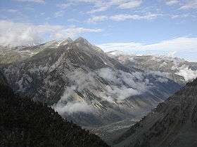
View from Zoji La | |
| Elevation | 3,528 m (11,575 ft) |
| Traversed by | Srinagar-Leh Highway |
| Location | Jammu and Kashmir |
| Range | Himalaya |
| Coordinates | 34°16′44″N 75°28′19″E / 34.27889°N 75.47194°ECoordinates: 34°16′44″N 75°28′19″E / 34.27889°N 75.47194°E |
Zoji La (Ladakhi: ཟོ་ཇི་ ལཱ་; ) is a high mountain pass in Jammu and Kashmir, India, located on the Indian National Highway 1D between Srinagar and Leh in the western section of the Himalayan mountain range. Though often referred to as Zojila Pass in the foreign press, the correct English translation is Zoji Pass or simply Zojila, since the suffix 'La' itself means pass in several Himalayan languages.The usage of the word "La" can also be seen in the Khardung La, Fotu La, Namika La and Pensi La etc. In modern-day North Indian languages, 'La' (ला) and 'Darra' (दर्रा) are both used interchangeably to mean a mountain pass.
Zoji La is 9 km (5.6 mi) from Sonamarg and provides a vital link between Ladakh and Kashmir Valley. It runs at an elevation of approximately 3,528 metres (11,575 ft), and is the second highest pass after Fotu La on the Srinagar-Leh National Highway. It is often closed during winter, though the Border Roads Organisation (BRO) is working to extend traffic to most parts of the year. The Beacon Force unit of the BRO is responsible for clearing and maintenance of the road during Winter.
During the Indo-Pakistani War of 1947, Zoji La was seized by Pakistani fighters in 1948 in their campaign to capture Ladakh. The pass was captured by Indian forces on 1 November in an assault codenamed Operation Bison, which achieved success primarily due to the surprise use of tanks, then the highest altitude at which tanks had operated in combat in the world.[1]
Gallery
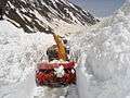 Snow cutting machine on the Zoji La
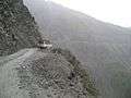
 Street up to Zoji La (coming from Srinagar)
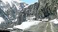 Vehicles proceeding towards the valley through the Zoji La
See also
References
- ↑ Sinha, Lt. Gen. S.K. (1977). Operation Rescue:Military Operations in Jammu & Kashmir 1947-49. New Delhi: Vision Books. pp. 103–127. ISBN 81-7094-012-5. Retrieved 4 August 2010.