1887 Atlantic hurricane season
| |
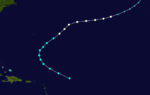
| Season summary map |
| First system formed |
May 15, 1887 |
| Last system dissipated |
December 12, 1887 |
| Strongest storm1 |
Seven – 952 mbar (hPa) (28.11 inHg), 125 mph (205 km/h) |
| Total depressions |
19 |
| Total storms |
19 |
| Hurricanes |
11 |
| Major hurricanes (Cat. 3+) |
2 |
| Total fatalities |
2+ total |
| Total damage |
Unknown |
| 1Strongest storm is determined by lowest pressure |
Atlantic hurricane seasons
1885, 1886, 1887, 1888, 1889 |
The 1887 Atlantic hurricane season was the third most active Atlantic hurricane season on record, tying with the 1995, 2010, 2011, and the 2012 seasons for third most number of storms. The season ran through the summer and almost all of the fall in 1887, and was surpassed in total number of tropical cyclones only by the seasons of 1933 and the record-breaking 2005. The 1887 season saw tropical activity as early as May, and as late as December. Tropical cyclones that did not approach populated areas or shipping lanes, especially if they were relatively weak and of short duration, may have remained undetected. Because technologies such as satellite monitoring were not available until the 1960s, historical data on tropical cyclones from this period may not be comprehensive. An undercount bias of zero to six tropical cyclones per year between 1851 and 1885 and zero to four per year between 1886 and 1910 has been estimated.[1] Of the known 1887 cyclones, Tropical Storm One and Tropical Storm Three were first documented in 1996 by Jose Fernandez-Partagas and Henry Diaz. They also proposed large alterations to the known tracks of several of the other 1887 storms.[2] Later re-analysis led to the known duration of Hurricane Six, and also that of Hurricane Fifteen, being increased.[3]
Ten of the season's nineteen known storms attained hurricane status. However, only two of these storms became major hurricanes, with sustained winds of over 111 mph (179 km/h); the strongest reached peak winds of 125 mph (205 km/h), with a minimum barometric pressure of 952 mbar (28.1 inHg) off the East Coast of the United States in late August. Only a few of the storms during the 1887 season did not impact land, but there was a low number of deaths.
Timeline
Storms
Tropical Storm One
| Tropical storm (SSHWS) |
|
|
| Duration |
May 15 – May 18 |
| Peak intensity |
70 mph (110 km/h) (1-min) ≤997 mbar (hPa) |
The first storm of the season formed south of Bermuda on May 15, outside of the season boundaries and moved to the northwest, staying out to sea. After peaking at 70 mph (110 km/h) late the next day, it turned northward, and became extratropical on May 18 over Newfoundland.
Tropical Storm Two
| Tropical storm (SSHWS) |
|
|
| Duration |
May 17 – May 21 |
| Peak intensity |
60 mph (95 km/h) (1-min) ≤1002 mbar (hPa) |
Another May storm formed south of Jamaica on May 17, way outside of the season and moved generally northward. It crossed Cuba on May 19 as a tropical storm, and moved out to sea. Two peaked at 60 mph (95 km/h) twice, once on May 18 and May 20. Two dissipated on May May 21 in the Atlantic Ocean. When this storm and the first storm were active simultaneously from May 17 to May 18, it became the earliest for two storms to be active at one time.
Tropical Storm Three
| Tropical storm (SSHWS) |
|
|
| Duration |
June 12 – June 14 |
| Peak intensity |
40 mph (65 km/h) (1-min) 1004 mbar (hPa) |
A weak tropical storm, which began its life in the northwest Caribbean Sea on June 12. Three peaked at 40 mph (65 km/h) and moved northward through the Gulf of Mexico, and dissipated on June 14 after making landfall in Mississippi.
Hurricane Four
| Category 2 hurricane (SSHWS) |
|
|
| Duration |
July 20 – July 28 |
| Peak intensity |
100 mph (155 km/h) (1-min) 981 mbar (hPa) |
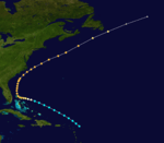
On July 20 a tropical storm formed 150 miles southeast of Barbados.[4] The next day it passed south of the island as a Category 1 hurricane and caused several vessels to be wrecked or to be run aground there. The hurricane continued westward into the Caribbean Sea, becoming a strong Category 2 hurricane with winds of 100 mph (160 km/h) on July 22.
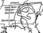
Although the hurricane passed far to the south of Cuba, it caused several vessels to sink at Batabanó and brought heavy rain and flooding to the islands interior. Continuing westward, the hurricane passed over the eastern tip of the Yucatán Peninsula before first turning northward and then northeasterly. It made landfall on the Florida panhandle on the morning of July 27 as a Category 1 hurricane, with a wind speed of 85 mph (140 km/h). The storm continued northward, as a tropical storm, before dissipating late on July 28 near Augusta, Georgia. The storm and its remnants brought heavy rain to the Southeast, up to 8 inches in Cedar Keys and a maximum of 16.5 inches (420 mm) at Union Point, Georgia.[5]The cyclone caused extensive damage to the cotton crop throughout Georgia and Alabama.[2]
Tropical Storm Five
| Tropical storm (SSHWS) |
|
|
| Duration |
July 30 – August 8 |
| Peak intensity |
60 mph (95 km/h) (1-min) 1001 mbar (hPa) |
Tropical Depression Five formed east of the Windward Islands on July 30 and moved northwestward across the Caribbean Sea, strengthening into a storm and reaching peak winds of 60 mph (97 km/h) on August 2 near St. Vincent before dissipating near Cuba the same day.
Hurricane Six
| Category 3 hurricane (SSHWS) |
|
|
| Duration |
August 14 – August 22 |
| Peak intensity |
120 mph (195 km/h) (1-min) ≤967 mbar (hPa) |
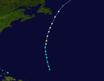
The season's first of two major hurricanes, both following a very similar Cape Verde-type hurricane path in mid-August, but remained offshore. Six formed on August 14 in the middle of the Atlantic Ocean. Six started moving toward the Carolina coast and moved far north and peaked as a 120 mph (190 km/h) & 967 mbar major hurricane on August 20, when rapid weakening began. Six was declared extratropical two days later.
Hurricane Seven
| Category 3 hurricane (SSHWS) |
|
|
| Duration |
August 18 – August 27 |
| Peak intensity |
125 mph (205 km/h) (1-min) 946 mbar (hPa) |
The season's second of two major hurricanes, both following a very similar Cape Verde-type hurricane path in mid-August, but remained offshore. Seven formed from a depression on August 18 into Tropical Storm 7 and followed the same track as Six. Seven peaked at 125 mph (205 km/h) winds for three straight days as a major hurricane and rapid weakening began. Seven was declared extratropical on August 27.
Hurricane Eight
| Category 2 hurricane (SSHWS) |
|
|
| Duration |
September 1 – September 4 |
| Peak intensity |
105 mph (165 km/h) (1-min) 963 mbar (hPa) |
On September 1, a tropical storm formed in the central Atlantic Ocean. It moved northwestward, becoming a hurricane on September 2. The hurricane turned to the northeast, and peaked at 105 mph (169 km/h) as a Category 2 hurricane before becoming extratropical on September 4. The extratropical storm remained until September 6, when it dissipated off the coast of Ireland.
Hurricane Nine
| Category 2 hurricane (SSHWS) |
|
|
| Duration |
September 11 – September 22 |
| Peak intensity |
100 mph (155 km/h) (1-min) 973 mbar (hPa) |
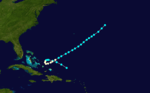
A hurricane, which was first observed on September 11 to the east of the Lesser Antilles, traversed the Caribbean Sea, remaining away from land until hitting extreme northeast Yucatán Peninsula on September 17. It moved across the Gulf of Mexico, and weakened slightly before landfall as it hit near Brownsville, Texas on September 21 as an 85 mph (140 km/h) hurricane. The storm rapidly weakened over Texas and northeast Mexico, and dissipated on the 22nd.
Rainfall was reported at 8 inches at Brownsville, Texas and on September 21 and 2.26 inches (57 mm) on September 22.[4][6] Thirty-six hours of rainfall flooded low-lying areas and fourteen sailors were lost at sea.[7]
Hurricane Ten
| Category 1 hurricane (SSHWS) |
|
|
| Duration |
September 14 – September 18 |
| Peak intensity |
80 mph (130 km/h) (1-min) 983 mbar (hPa) |
On September 14, the tenth storm formed in the central Atlantic Ocean and moved northward. The storm peaked at 80 mph (130 km/h) with pressure of 983 mbar on September 16. It started losing its tropical characteristics while northeast of Newfoundland on September 18 and was soon declared as an extratropical storm.
Tropical Storm Eleven
| Tropical storm (SSHWS) |
|
|
| Duration |
October 6 – October 9 |
| Peak intensity |
60 mph (95 km/h) (1-min) |
The eleventh tropical storm of the season developed in the western Caribbean Sea on October 6. The storm peaked at 60 mph (95 km/h), then started moving westward through the Yucatán Peninsula and Bay of Campeche. Eleven dissipated on October 9 after making its second landfall in Mexico.
Tropical Storm Twelve
| Tropical storm (SSHWS) |
|
|
| Duration |
October 8 – October 9 |
| Peak intensity |
70 mph (110 km/h) (1-min) ≤994 mbar (hPa) |
A depression strengthened into Tropical Storm Twelve on October 8 and peaked at 70 mph (110 km/h) winds later that day. After passing over Bermuda, Twelve dissipated the next day. Twelve was the shortest lived storm in the 1887 season lasting only two days (October 8 & 9th).
Hurricane Thirteen
| Category 1 hurricane (SSHWS) |
|
|
| Duration |
October 9 – October 20 |
| Peak intensity |
85 mph (140 km/h) (1-min) 981 mbar (hPa) |
A tropical storm was first seen on October 9 to the northeast of the Lesser Antilles. It moved westward to cross Puerto Rico and Hispaniola, before strengthening into a hurricane while south of Cuba on October 12. The hurricane maintained a peak wind speed of 85 mph (137 km/h) for four days, from October 15 to October 19, whilst crossing the Gulf of Mexico. It struck the Louisiana coast near New Orleans on October 19 as a tropical storm. Considerable damage and some flooding were seen in New Orleans, trees were blown down in Algiers and there were significant amounts of crop damage in Abbeville and Iberville Parish.[8] The storm swept across Georgia and the Carolinas before becoming dissipating at sea early on October 20.[9]
Around October 14, a storm moved over Belize, causing moderate crop damage and disruption in the southern part of the country. Because the 13th storm of the season existed at the same time to its northeast, this system was not included, though further research is under way to determine if it was a new storm or a variation of the 13th storm of the season.
Hurricane Fourteen
| Category 1 hurricane (SSHWS) |
|
|
| Duration |
October 10 – October 12 |
| Peak intensity |
85 mph (140 km/h) (1-min) ≤989 mbar (hPa) |
On October 10, a depression strengthened into Tropical Storm Fourteen and moved across the ocean. Fourteen peaked with 85 mph (140 km/h) winds as a Category 1 hurricane on October 11. On October 12, Fourteen weakened and was declared extratropical.
Hurricane Fifteen
| Category 2 hurricane (SSHWS) |
|
|
| Duration |
October 15 – October 19 |
| Peak intensity |
105 mph (165 km/h) (1-min) ≤975 mbar (hPa) |
A tropical storm was discovered on late afternoon of October 15 and was named Tropical Storm Fifteen on that day with 80 mph (130 km/h) winds. From October 15 to 16th, Fifteen peaked at 105 mph (169 km/h) winds making it a Category 2 hurricane. Fifteen stayed out to sea and dissipated on October 19.
Tropical Storm Sixteen
| Tropical storm (SSHWS) |
|
|
| Duration |
October 29 – October 31 |
| Peak intensity |
70 mph (110 km/h) (1-min) 993 mbar (hPa) |
A tropical storm formed on October 27 and took a long, erratic track across the Caribbean Sea and the Atlantic Ocean. Sixteen made landfall and moved across Florida as a tropical storm on October 30. Sixteen paralleled the Carolina coastline and peaked at an 70 mph (110 km/h) storm with a tropical pressure of 993 mbar on October 31. Sixteen was declared extratropical a day later and hit an extratropical peak of 80 mph (130 km/h) and a 990 mbar extratropical pressure. The storm was dissipated on November 6. Sixteen caused a ship to capsize, killing 2 sailors, and resulted in the loss of four other ships.
Hurricane Seventeen
| Category 1 hurricane (SSHWS) |
|
|
| Duration |
November 27 – December 4 |
| Peak intensity |
80 mph (130 km/h) (1-min) |
On November 27, a tropical storm formed north of Puerto Rico. It moved to the west-northwest, and looped to the northeast. While looping, it peaked at 80 mph (130 km/h), but rapid weakening began while the storm was moving to the northeast. The storm was last seen on December 4 in the open Atlantic Ocean.
Hurricane Eighteen
| Category 1 hurricane (SSHWS) |
|
|
| Duration |
December 4 – December 8 |
| Peak intensity |
80 mph (130 km/h) (1-min) |
The 18th storm was first seen to the northeast of the Lesser Antilles on December 4. It moved northwestward at first, then turned to the northeast, strengthening into a hurricane on December 7 before rapid weakening began and Eighteen was declared an extratropical storm on December 9.
Tropical Storm Nineteen
| Tropical storm (SSHWS) |
|
|
| Duration |
December 7 – December 12 |
| Peak intensity |
60 mph (95 km/h) (1-min) |
The 19th and final tropical storm formed on December 7 and moved westward through the Caribbean Sea. Nineteen peaked in intensity on December 10 with 60 mph (95 km/h) winds. Nineteen passed by St. Vincent and continued westward until dissipating near the coast of Costa Rica on December 12. When Tropical Storm Nineteen formed on December 7, it made 1887 the year with the most off-season storms (five). Nineteen is the only tropical storm recorded to make landfall in Costa Rica.
See also
References
- ↑ Landsea, C. W. (2004). "The Atlantic hurricane database re-analysis project: Documentation for the 1851–1910 alterations and additions to the HURDAT database". In Murname, R. J.; Liu, K.-B. Hurricanes and Typhoons: Past, Present and Future. New York: Columbia University Press. pp. 177–221. ISBN 0-231-12388-4.
- 1 2 Partagas, J.F. and H.F. Diaz, 1996a "A reconstruction of historical Tropical Cyclone frequency in the Atlantic from documentary and other historical sources Part III: 1881-1890" Climate Diagnostics Center, NOAA, Boulder, CO
- ↑ Hurricane Research Division (2008). "Documentation of Atlantic Tropical Cyclones Changes in HURDAT". National Oceanic and Atmospheric Administration. Retrieved 2011-03-14.
- 1 2 Hurricane Research Division (2012). "Easy to Read HURDAT". National Oceanic and Atmospheric Administration. Retrieved October 23, 2012.
- ↑ United States Corp of Engineers (1945). Storm Total Rainfall In The United States. War Department. p. SA 3-1.
- ↑ STORM 9- HURDAT
- ↑ David Roth (2010-02-04). "Texas Hurricane History" (PDF). National Weather Service. Retrieved 2011-06-22.
- ↑ David M. Roth (2010-01-13). Louisiana Hurricane History (PDF). National Weather Service, Southern Region Headquarters. Retrieved 2011-01-25.
- ↑ Hudgins,James E. (2000). "Tropical cyclones affecting North Carolina since 1586 - An Historical Perspective" (PDF). National Oceanic and Atmospheric Administration.
External links
Most intense Atlantic hurricane seasons |
|---|
|
|
|
|
|
Note: There is an undercount bias of zero to six tropical cyclones per year between 1851 and 1885 and zero to four per year between 1886 and 1910, due to the lack of modern observation techniques, see Tropical cyclone observation. |