A27 motorway (Netherlands)
| ||||
|---|---|---|---|---|
| Rijksweg 27 | ||||
|
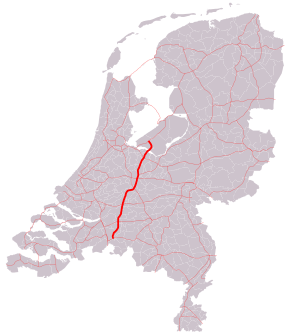
Motorways in the Netherlands with the Rijksweg 27 part in bold | ||||
| Route information | ||||
|
Part of | ||||
| Maintained by Rijkswaterstaat[1] | ||||
| Major junctions | ||||
| South end: |
| |||
| North end: |
| |||
| Location | ||||
| Provinces: | North Brabant, South Holland, Utrecht, North Holland, Flevoland | |||
| Highway system | ||||
| ||||

The A27 motorway is a motorway in the Netherlands. It is approximately 109 kilometers in length.
The A27 is located in the Dutch provinces North Brabant, South Holland, Utrecht, North Holland, and Flevoland. It connects the city of Breda with the Almere. On its way, it passes the cities of Gorinchem, Utrecht and Hilversum.


Route description
'Shared section' with A58 motorway
Although not officially a part of the Rijksweg 27, the section of the A58 motorway between interchanges Galder and Sint-Annabosch is also being referred to as A27, next to the road's official reference number A58.
Technically this situation is incorrect, since the A27's official start is only at interchange Sint-Annabosch. However, the reference A27 has probably been added to the road signs to help traffic coming from Antwerp in finding their way from the A16 / E19 towards the A27.
European routes
No major European routes follow the A27 motorway. The only one to follow it, is the E311 road between interchange Sint-Annabosch near Breda and interchange Lunetten near Utrecht. This section of the A27 immediately comprises the entire E311 road, since it does not follow any other roads.
Besides, the 'shared section' with the A58 is part of the European route E312.
History
The northernmost section, connecting the town of Huizen with Almere, has been opened in 1999.
Exit list
| Province | Municipality | km | mi | Exit | Destinations | Notes |
|---|---|---|---|---|---|---|
| North Brabant | Breda | — | West end of A58 and E 312 overlap | |||
| 14 | ||||||
| — | East end of A58 and E 312 overlap; south end of E 311 overlap | |||||
| 15 | Franklin Rooseveltlaan | |||||
| 16 | ||||||
| Oosterhout | 17 | |||||
| 18 | Wilhelminakanaal Noord | Northbound entrance and southbound exit only | ||||
| 19 | ||||||
| Geertruidenberg | — | |||||
| 20 | Maasdijk / Keizersveer | |||||
| Werkendam | 21 | |||||
| 22 | ||||||
| 23 | Tol | |||||
| South Holland | Gorinchem | 24 | Nieuwe Wolpherensedijk | |||
| — | ||||||
| Giessenlanden | 25 | |||||
| Zederik | 26 | Lakerveld | ||||
| Utrecht | Vianen | |||||
| 27 | Hagenweg / Ingenieur D.S. Tuijnmanweg | |||||
| Nieuwegein | 28 | Waterliniedok / De Kroon | ||||
| Houten | 29 | De Staart | ||||
| Utrecht | — | North end of E 311 overlap; south end of E 30 overlap | ||||
| — | North end of E 30 overlap | |||||
| 30 | Blitse Rading | |||||
| 31 | ||||||
| De Bilt | 32 | |||||
| North Holland | Hilversum | 33 | Diependaalselaan / Oostereind | |||
| Utrecht | Eemnes | — | ||||
| 34 | Verlegde Laarderweg / Zuidersingel | |||||
| North Holland–Utrecht province line | Huizen | 35 | Randweg Oost / Stichtseweg | |||
| Flevoland | Almere | 36 | ||||
| 37 | ||||||
| — | ||||||
1.000 mi = 1.609 km; 1.000 km = 0.621 mi
| ||||||
See also
- List of motorways in the Netherlands
- List of E-roads in the Netherlands
 Netherlands portal
 Roads portal
References
- ↑ "Wegbeheerders". Rijkswaterstaat. Retrieved 14 December 2014.
External links
![]() Media related to A27 motorway (Netherlands) at Wikimedia Commons
Media related to A27 motorway (Netherlands) at Wikimedia Commons