Utrecht
| Utrecht | |||
|---|---|---|---|
| City and Municipality | |||
|
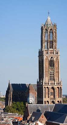
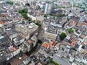
Aerial view of the Dom Tower in the city centre | |||
| |||
.svg.png) Location in Utrecht | |||
| Coordinates: 52°5′N 5°7′E / 52.083°N 5.117°ECoordinates: 52°5′N 5°7′E / 52.083°N 5.117°E | |||
| Country | Netherlands | ||
| Province | Utrecht | ||
| Government[1] | |||
| • Body | Municipal council | ||
| • Mayor | Jan van Zanen (VVD) | ||
| Area[2] | |||
| • Municipality | 99.21 km2 (38.31 sq mi) | ||
| • Land | 94.33 km2 (36.42 sq mi) | ||
| • Water | 4.88 km2 (1.88 sq mi) | ||
| • Randstad | 3,043 km2 (1,175 sq mi) | ||
| Elevation[3] | 5 m (16 ft) | ||
| Population (Municipality, May 2014; Urban and Metro, May 2014; Randstad, 2011)[2][4][5] | |||
| • Municipality | 330,772 | ||
| • Density | 3,507/km2 (9,080/sq mi) | ||
| • Urban | 489,734 | ||
| • Metro | 656,342 | ||
| • Randstad | 6,979,500 | ||
| Demonym(s) | Utrechter, Utrechtenaar[nb 1] | ||
| Time zone | CET (UTC+1) | ||
| • Summer (DST) | CEST (UTC+2) | ||
| Postcode | 3450–3455, 3500–3585 | ||
| Area code | 030 | ||
| Website |
www | ||


Utrecht (/ˈjuːtrɛkt/; Dutch pronunciation: [ˈytrɛxt]) is the capital and most populous city in the Dutch province of Utrecht. It is located in the eastern corner of the Randstad conurbation and is the fourth largest city in the Netherlands with a population of 330,772 in 2014.
Utrecht's ancient city centre features many buildings and structures several dating as far back as the High Middle Ages. It has been the religious centre of the Netherlands since the 8th century. It lost the status of prince-bishopric but remains the main religious center in the country. Utrecht was the most important city in the Netherlands until the Dutch Golden Age, when it was surpassed by Amsterdam as the country's cultural centre and most populous city.
Utrecht is host to Utrecht University, the largest university in the Netherlands, as well as several other institutions of higher education. Due to its central position within the country, it is an important transport hub for both rail and road transport. It has the second highest number of cultural events in the Netherlands, after Amsterdam.[6] In 2012, Lonely Planet included Utrecht in the top 10 of the world’s unsung places.
History
Origins (until 650)
.jpg)
Although there is some evidence of earlier inhabitation in the region of Utrecht, dating back to the Stone Age (app. 2200 BCE) and settling in the Bronze Age (app. 1800–800 BCE),[7] the founding date of the city is usually related to the construction of a Roman fortification (castellum), probably built in around 50 CE. A series of such fortresses was built after the Roman emperor Claudius decided the empire should not expand north. To consolidate the border the limes Germanicus defense line was constructed [8] along the main branch of the river Rhine, which at that time flowed through a more northern bed compared to today (what is now the Kromme Rijn). These fortresses were designed to house a cohort of about 500 Roman soldiers. Near the fort settlements would grow housing artisans, traders and soldiers' wives and children.
In Roman times, the name of the Utrecht fortress was simply Traiectum, denoting its location at a possible Rhine crossing. Traiectum became Dutch Trecht; with the U from Old Dutch "uut" (downriver) added to distinguish U-trecht from Maas-tricht.[9][10] In 11th-century official documents it was Latinized as Ultra Traiectum. Around the year 200, the wooden walls of the fortification were replaced by sturdier tuff stone walls,[11] remnants of which are still to be found below the buildings around Dom Square.
From the middle of the 3rd century Germanic tribes regularly invaded the Roman territories. Around 275 the Romans could no longer maintain the northern border and Utrecht was abandoned.[8] Little is known about the next period 270–650. Utrecht is first spoken of again several centuries after the Romans left. Under the influence of the growing realms of the Franks, during Dagobert I's reign in the 7th century, a church was built within the walls of the Roman fortress.[8] In ongoing border conflicts with the Frisians this first church was destroyed.
Centre of Christianity in the Netherlands (650–1579)
By the mid-7th century, English and Irish missionaries set out to convert the Frisians. The pope appointed their leader, Willibrordus, bishop of the Frisians. The tenure of Willibrordus is generally considered to be the beginning of the Bishopric of Utrecht.[8] In 723, the Frankish leader Charles Martel bestowed the fortress in Utrecht and the surrounding lands as the base of the bishops. From then on Utrecht became one of the most influential seats of power for the Roman Catholic Church in the Netherlands. The archbishops of Utrecht were based at the uneasy northern border of the Carolingian Empire. In addition, the city of Utrecht had competition from the nearby trading centre Dorestad.[8] After the fall of Dorestad around 850, Utrecht became one of the most important cities in the Netherlands.[12] The importance of Utrecht as a centre of Christianity is illustrated by the election of the Utrecht-born Adriaan Florenszoon Boeyens as pope in 1522 (the last non-Italian pope before John Paul II).
Prince-bishops
When the Frankish rulers established the system of feudalism, the Bishops of Utrecht came to exercise worldly power as prince-bishops.[8] The territory of the bishopric not only included the modern province of Utrecht (Nedersticht, 'lower Sticht'), but also extended to the northeast. The feudal conflict of the Middle Ages heavily affected Utrecht. The prince-bishopric was involved in almost continuous conflicts with the Counts of Holland and the Dukes of Guelders.[13] The Veluwe region was seized by Guelders, but large areas in the modern province of Overijssel remained as the Oversticht.
Clerical buildings
Several churches and monasteries were built inside, or close to, the city of Utrecht. The most dominant of these was the Cathedral of Saint Martin, inside the old Roman fortress. The construction of the present Gothic building was begun in 1254 after an earlier romanesque construction had been badly damaged by fire. The choir and transept were finished from 1320 and were followed then by the ambitious Dom tower.[8] The last part to be constructed was the central nave, from 1420. By that time, however, the age of the great cathedrals had come to an end and declining finances prevented the ambitious project from being finished, the construction of the central nave being suspended before the planned flying buttresses could be finished.[8] Besides the cathedral there were four collegiate churches in Utrecht: St. Salvator's Church (demolished in the 16th century), on the Dom square, dating back to the early 8th century.[14] Saint John (Janskerk), originating in 1040;[15] Saint Peter, building started in 1039[16] and Saint Mary's church building started around 1090 (demolished in the early 19th century, cloister survives).[17] Besides these churches the city housed St. Paul's Abbey,[18] the 15th-century beguinage of St. Nicholas, and a 14th-century chapter house of the Teutonic Knights.[19]
Besides these buildings which belonged to the bishopric; an additional four parish churches were constructed in the city: the Jacobikerk (dedicated to Saint James), founded in the 11th century, with the current Gothic church dating back to the 14th century;[20] the Buurkerk (Neighbourhood-church) of the 11th-century parish in the centre of the city; Nicolaichurch (dedicated to Saint Nicholas), from the 12th century[21] and the 13th-century Geertekerk (dedicated to Saint Gertrude of Nivelles).[22]
City of Utrecht
The location on the banks of the river Rhine allowed Utrecht to become an important trade centre in the Northern Netherlands. The growing town Utrecht was granted city rights by Henry V in 1122. When the main flow of the Rhine moved south, the old bed, which still flowed through the heart of the town became evermore canalized; and the wharf system was built as an inner city harbour system.[23] On the wharfs storage facilities (werfkelders) were built, on top of which the main street, including houses was constructed. The wharfs and the cellars are accessible from a platform at water level with stairs descending from the street level to form a unique structure.[nb 2][24] The relations between the bishop, who controlled many lands outside of the city, and the citizens of Utrecht was not always easy.[8] The bishop, for example dammed the Kromme Rijn at Wijk bij Duurstede to protect his estates from flooding. This threatened shipping for the city and led the city of Utrecht to commission a canal to ensure access to the town for shipping trade: the Vaartse Rijn, connecting Utrecht to the Hollandse IJssel at IJsselstein.
The end of independence
In 1528 the bishop lost secular power over both Neder- and Oversticht – which included the city of Utrecht – to Charles V, Holy Roman Emperor. Charles V combined the Seventeen Provinces (the current Benelux and the northern parts of France) as a personal union. This ended the prince-bishopric Utrecht, as the secular rule was now the lordship of Utrecht, with the religious power remaining with the bishop, although Charles V had gained the right to appoint new bishops. In 1559 the bishopric of Utrecht was raised to archbishopric to make it the religious center of the Northern ecclesiastical province in the Seventeen provinces.
The transition from independence to a relatively minor part of a larger union was not easily accepted. To quell uprisings Charles V was struggling to exert his power over the citizens of the city, who had struggled to gain a certain level of independence from the bishops and were not willing to cede this to their new lord. The heavily fortified castle Vredenburg was built to house a large garrison whose main task was to maintain control over the city. The castle would last less than 50 years before it was demolished in an uprising in the early stages of the Dutch Revolt.
Republic of the Netherlands (1579–1806)
.jpg)
In 1579 the northern seven provinces signed the Union of Utrecht, in which they decided to join forces against Spanish rule. The Union of Utrecht is seen as the beginning of the Dutch Republic. In 1580 the new and predominantly Protestant state abolished the bishoprics, including the archbishopric of Utrecht. The stadtholders disapproved of the independent course of the Utrecht bourgeoisie and brought the city under much more direct control of the republic; which shifted the power towards its dominant province Holland. This was the start of a long period of stagnation of trade and development in Utrecht. Utrecht remained an atypical city in the new republic with about 40% Catholic in the mid-17th-century, and even more among the elite groups, who included many rural nobility and gentry with town houses there.[25]
The fortified city temporarily fell to the French invasion in 1672 (the Disaster Year); where the French invasion was only stopped west of Utrecht at the Old Hollandic Waterline. In 1674, only two years after the French left, the centre of Utrecht was struck by a tornado. The halt to building before construction of flying buttresses in the 15th century now proved to be the undoing of the central section of the cathedral of St Martin church which collapsed; creating the current Dom square between the tower and choir. In 1713, Utrecht hosted one of the first international peace negotiations when the Treaty of Utrecht settled the War of the Spanish Succession. Since 1723 Utrecht became the centre of the non-Roman Old Catholic Churches in the world.
Modern history (1815–present)
In the early 19th century, the role of Utrecht as a fortified town had become obsolete. The fortifications of the Nieuwe Hollandse Waterlinie were moved east of Utrecht. The town walls could now be demolished to allow for expansion. The moats remained intact and formed an important feature of the Zocher plantsoen, an English style landscape park that remains largely intact today. Growth of the city increased when, in 1843, a railway connecting Utrecht to Amsterdam was opened. After that, Utrecht gradually became the main hub of the Dutch railway network. With the industrial revolution finally gathering speed in the Netherlands and the ramparts taken down, Utrecht began to grow far beyond the medieval centre. In 1853, the Dutch government allowed the bishopric of Utrecht to be reinstated by Rome, and Utrecht became the centre of Dutch Catholicism once more. From the 1880s onward neighbourhoods such as Oudwijk, Wittevrouwen, Vogelenbuurt to the East, and Lombok to the West were developed. New middle class residential areas, such as Tuindorp and Oog in Al, were built in the 1920s and 1930s. During this period, several Jugendstil houses and office buildings were built, followed by Rietveld who built the Rietveld Schröder House (1924), and Dudok's construction of the city theater (1941).
During World War II, Utrecht was held by the Germans until the general German surrender of the Netherlands on 5 May 1945. British and Canadian troops that had surrounded the city entered it after that surrender, on 7 May 1945. After the end of World War II, the city has grown considerably when new neighbourhoods such as Overvecht, Kanaleneiland, Hoograven and Lunetten were built. Around 2000 the city the Leidsche Rijn housing area was developed as the next extension of the city to the west.
The area surrounding Utrecht Centraal railway station and the station itself were developed following modernist ideas of the 1960s, in a brutalist style. This led to the construction of the shopping mall Hoog Catharijne, music centre Vredenburg (Hertzberger, 1979), and conversion of part of the ancient canal structure into a highway (Catherijnebaan). Protest against further modernisation of the city centre followed even before the last buildings were finalised. In the early 21st century the whole area is being redeveloped. The redeveloped music centre opened in 2014 where the original Vredenburg concert and rock and jazz halls are brought together in a single building.
Geography
Climate
Utrecht experiences a temperate oceanic climate (Köppen climate classification Cfb) similar to almost all of the Netherlands.
| Climate data for De Bilt | |||||||||||||
|---|---|---|---|---|---|---|---|---|---|---|---|---|---|
| Month | Jan | Feb | Mar | Apr | May | Jun | Jul | Aug | Sep | Oct | Nov | Dec | Year |
| Record high °C (°F) | 15.1 (59.2) |
17.3 (63.1) |
23.9 (75) |
28.9 (84) |
33.6 (92.5) |
36.8 (98.2) |
35.7 (96.3) |
35.3 (95.5) |
34.2 (93.6) |
26.7 (80.1) |
18.7 (65.7) |
15.3 (59.5) |
36.8 (98.2) |
| Average high °C (°F) | 5.6 (42.1) |
6.4 (43.5) |
10.0 (50) |
14.0 (57.2) |
18.0 (64.4) |
20.4 (68.7) |
22.8 (73) |
22.6 (72.7) |
19.1 (66.4) |
14.6 (58.3) |
9.6 (49.3) |
6.1 (43) |
14.1 (57.4) |
| Daily mean °C (°F) | 3.1 (37.6) |
3.3 (37.9) |
6.2 (43.2) |
9.2 (48.6) |
13.1 (55.6) |
15.6 (60.1) |
17.9 (64.2) |
17.5 (63.5) |
14.5 (58.1) |
10.7 (51.3) |
6.7 (44.1) |
3.7 (38.7) |
10.1 (50.2) |
| Average low °C (°F) | 0.3 (32.5) |
0.2 (32.4) |
2.3 (36.1) |
4.1 (39.4) |
7.8 (46) |
10.5 (50.9) |
12.8 (55) |
12.3 (54.1) |
9.9 (49.8) |
6.9 (44.4) |
3.6 (38.5) |
1.0 (33.8) |
6.0 (42.8) |
| Record low °C (°F) | −24.8 (−12.6) |
−21.6 (−6.9) |
−14.4 (6.1) |
−6.6 (20.1) |
−3.7 (25.3) |
0.2 (32.4) |
3.2 (37.8) |
3.8 (38.8) |
−0.7 (30.7) |
−7.8 (18) |
−14.4 (6.1) |
−16.6 (2.1) |
−24.8 (−12.6) |
| Average precipitation mm (inches) | 69.6 (2.74) |
55.8 (2.197) |
66.8 (2.63) |
42.3 (1.665) |
61.9 (2.437) |
65.6 (2.583) |
81.1 (3.193) |
72.9 (2.87) |
78.1 (3.075) |
82.8 (3.26) |
79.8 (3.142) |
75.8 (2.984) |
832.5 (32.776) |
| Average precipitation days (≥ 1 mm) | 12 | 10 | 11 | 9 | 10 | 10 | 10 | 10 | 11 | 12 | 13 | 12 | 131 |
| Average snowy days | 6 | 6 | 4 | 2 | 0 | 0 | 0 | 0 | 0 | 0 | 2 | 5 | 25 |
| Average relative humidity (%) | 87 | 84 | 81 | 75 | 75 | 76 | 77 | 79 | 84 | 86 | 89 | 89 | 81.8 |
| Mean monthly sunshine hours | 62.3 | 85.7 | 121.6 | 173.6 | 207.2 | 193.9 | 206.0 | 187.7 | 138.3 | 112.9 | 63.0 | 49.3 | 1,601.6 |
| Source #1: Royal Netherlands Meteorological Institute (1981–2010 normals, snowy days normals for 1971–2000)[26] | |||||||||||||
| Source #2: Royal Netherlands Meteorological Institute (1901–present extremes)[27] | |||||||||||||
Population
Demographics
| Historical population | ||
|---|---|---|
| Year | Pop. | ±% p.a. |
| 1400 | 13,000 | — |
| 1481 | 17,250 | +0.35% |
| 1577 | 27,500 | +0.49% |
| 1623 | 30,000 | +0.19% |
| 1670 | 30,000 | +0.00% |
| 1748 | 25,244 | −0.22% |
| 1795 | 32,294 | +0.53% |
| 1900 | 102,086 | +1.10% |
| 1910 | 119,006 | +1.55% |
| 1920 | 138,334 | +1.52% |
| 1930 | 153,208 | +1.03% |
| 1940 | 165,029 | +0.75% |
| 1950 | 193,190 | +1.59% |
| 1960 | 254,186 | +2.78% |
| 1970 | 279,000 | +0.94% |
| 1980 | 236,208 | −1.65% |
| 1990 | 230,676 | −0.24% |
| 2000 | 233,667 | +0.13% |
| 2010 | 307,081 | +2.77% |
| 2011 | 312,634 | +1.81% |
| Source: Lourens & Lucassen 1997, pp. 87–88 (1400–1795) | ||
Utrecht city had a population of 296,305 in 2007. Utrecht is a growing municipality and projections are that the city's population will surpass 392,000 by 2025.[28]
Utrecht has a young population, with many inhabitants in the age category from 20 and 30 years, due to the presence of a large university. About 52% of the population is female, 48% is male. The majority of households (52.5%) in Utrecht are single person households. About 29% of people living in Utrecht are either married, or have another legal partnership. About 3% of the population of Utrecht is divorced.[28]
About 69% of the population is of Dutch ancestry. Approximately 10% of the population consists of immigrants from Western countries, while 21% of the population is of non-Western origin (9% Moroccan, 5% Turkish, 3% Surinamese and Dutch Caribbean and 5% of other countries).[28] Some of the city's boroughs have a relatively high percentage of originally non-Dutch inhabitants – i.e. Kanaleneiland (83%) and Overvecht (57%). Like Rotterdam, Amsterdam, The Hague and other large Dutch cities, Utrecht faces some socio-economic problems. About 38% percent of its population either earns a minimum income or is dependent on social welfare (17% of all households). Boroughs such as Kanaleneiland, Overvecht and Hoograven consist primarily of high-rise housing developments, and are known for relatively high poverty and crime rate.
| Population in Utrecht[29] | ||||
| Female | Age | Male | ||
|---|---|---|---|---|
| 22761 | 15% | 0–14 | 23994 | 17% |
| 44732 | 30% | 15–29 | 36165 | 26% |
| 36444 | 24% | 30–44 | 39434 | 28% |
| 15574 | 10% | 45–54 | 15996 | 11% |
| 11899 | 8% | 55–64 | 11484 | 8% |
| 8317 | 6% | 65–74 | 7457 | 5% |
| 9374 | 6% | 74+ | 4764 | 3% |
Religion
Utrecht has been the religious centre of the Netherlands since the 8th century. Currently it is the see of the Metropolitan Archbishop of Utrecht, the most senior Dutch Roman Catholic leader.[30][31] His ecclesiastical province covers the whole kingdom.
Utrecht is also the see of the archbishop of the Old Catholic church, titular head of the Union of Utrecht, and the location of the offices of the main Protestant church.
Population centres and agglomeration
The city of Utrecht is subdivided into 10 city quarters, which all have their own neighbourhood council and service center for civil affairs.

- Binnenstad
- Oost
- Leidsche Rijn
- West
- Overvecht
- Zuid
- Noordoost
- Zuidwest
- Noordwest
- Vleuten-De Meern
Utrecht is the centre of a densely populated area, which makes concise definitions of its agglomeration difficult, and somewhat arbitrary. The smaller Utrecht agglomeration of continuously built up areas counts some 420,000 inhabitants and includes Nieuwegein, IJsselstein and Maarssen. It is sometimes argued that the close by municipalities De Bilt, Zeist, Houten, Vianen, Driebergen-Rijsenburg (Utrechtse Heuvelrug), and Bunnik should also be counted towards the Utrecht agglomeration, bringing the total to 640,000 inhabitants. The larger region, including slightly more remote towns such as Woerden and Amersfoort counts up to 820,000 inhabitants.[32]
Cityscape

.jpg)
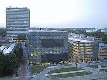
Utrecht's cityscape is dominated by the Dom Tower, the tallest belfry in the Netherlands and originally part of the Cathedral of Saint Martin.[33] An ongoing debate is over whether any building in or near the centre of town should surpass the Dom Tower in height (112 m (367 ft)). Nevertheless, some tall buildings are now being constructed that will become part of the skyline of Utrecht. The second tallest building of the city, the Rabobank-tower, was completed in 2010 and stands 105 metres (344 feet) tall.[34] Two antennas will increase that height to 120 metres (394 feet). Two other buildings were constructed around the Nieuw Galgenwaard stadium (2007). These buildings, the 'Kantoortoren Galghenwert' and 'Apollo Residence', stand 85.5 metres (280.5 feet) and 64.5 metres (211.6 feet) high respectively.
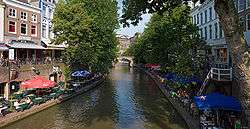
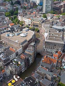
Another landmark is the old centre and the canal structure in the inner city. The Oudegracht is a curved canal, partly following the ancient main branch of the Rhine. It is lined with the unique wharf-basement structures that create a two-level street along the canals.[35] The inner city has largely retained its Medieval structure,[36] and the moat ringing the old town is largely intact.[37] Because of the role of Utrecht as a fortified city, construction outside the medieval centre and its city walls was restricted until the 19th century. Surrounding the medieval core there is a ring of late 19th- and early 20th-century neighbourhoods, with newer neighbourhoods positioned farther out.[38] The eastern part of Utrecht remains fairly open. The Dutch Water Line, moved east of the city in the early 19th century required open lines of fire, thus prohibiting all permanent constructions until the middle of the 20th century on the east side of the city.[39]
Due to the past importance of Utrecht as a religious centre, several monumental churches were erected, many of which have survived.[40] Most prominent is the Dom Church. Other notable churches include the romanesque St Peter's and St John's churches, the gothic churches of St James and St Nicholas, and the Buurkerk, now converted into a museum for automatically playing musical instruments .
Transport
Public transport
Because of its central location, Utrecht is well connected to the rest of the Netherlands and has a well-developed public transport network.
Heavy and light rail
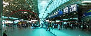
Utrecht Centraal is the main railway station of Utrecht. There are regular intercity services to all major Dutch cities; direct services to Schiphol Airport. Utrecht Centraal is a station on the night service, providing 7 days a week an all night service to (among others) Schiphol Airport, Amsterdam and Rotterdam. International InterCityExpress (ICE) services to Germany (and further) through Arnhem call at Utrecht Centraal. Regular local trains to all areas surrounding Utrecht also depart from Utrecht Centraal; and service several smaller stations: Utrecht Lunetten, Utrecht Vaartsche Rijn, Utrecht Overvecht, Utrecht Leidsche Rijn, Utrecht Terwijde, Utrecht Zuilen and Vleuten. A former station Utrecht Maliebaan closed in 1939 and has since been converted into the Dutch Railway Museum.
The Utrecht sneltram is a light rail scheme running southwards from Utrecht Centraal to the suburbs of IJsselstein, Kanaleneiland, Lombok and Nieuwegein. The sneltram began operations in 1983 and is currently operated by the private transport company Qbuzz. In 2018 the new extension to the Uithof will start operating creating a direct mass transit connection from the central station to the main Utrecht university campus.[41]
Utrecht is the location of the headquarters of Nederlandse Spoorwegen (English: Dutch Railways) – the largest rail operator in the Netherlands – and ProRail – the state-owned company responsible for the construction and maintenance of the country's rail infrastructure.
Bus transport
The main local and regional bus station of Utrecht is located adjacent to Utrecht Centraal railway station, at the East and West entrances. Due to large scale renovation and construction works at the railway station, the station's bus stops are changing frequently. As a general rule, westbound buses depart from the bus station on the west entrance, other buses from the east side station. Local buses in Utrecht are operated by Qbuzz – its services include a high-frequency service to the Uithof university district. The local bus fleet is one of Europe's cleanest, using only buses compliant with the Euro-VI standard as well as electric buses for inner city transport. Regional buses from the city are operated by Arriva and Connexxion.
The Utrecht Centraal railway station is also served by the pan-European services of Eurolines. Furthermore, it acts as departure and arrival place of many coach companies serving holiday resorts in Spain and France – and during winter in Austria and Switzerland.
Cycling
Like most Dutch cities, Utrecht has an extensive network of cycle paths, making cycling safe and popular. 33% of journeys within the city are by bicycle, more than any other mode of transport.[42] (Cars, for example, account for 30% of trips). Bicycles are used by young and old people, and by individuals and families. They are mostly traditional, upright, steel-framed bicycles, with few or no gears. There are also barrow bikes, for carrying shopping or small children. As thousands of bicycles are parked haphazardly in town, creating an eyesore but also impeding pedestrians, the City Council decided in 2014 to build the world's largest bicycle parking station, near the Central Railway Station. This 3-floor construction will cost an estimated 48 million Euro and will hold 12,500 bicycles. Completion is foreseen in 2018.[43]
Road transport
Utrecht is well-connected to the Dutch road network. Two of the most important major roads serve the city of Utrecht: the A12 and A2 motorways connect Amsterdam, Arnhem, The Hague and Maastricht, as well as Belgium and Germany. Other major motorways in the area are the Almere–Breda A27 and the Utrecht–Groningen A28.[44] Due to the increasing traffic and the ancient city plan, traffic congestion is a common phenomenon in and around Utrecht, causing elevated levels of air pollutants. This has led to a passionate debate in the city about the best way to improve the city's air quality.
Shipping
Utrecht has an industrial port located on the Amsterdam-Rijnkanaal.[45] The container terminal has a capacity of 80,000 containers a year. In 2003, the port facilitated the transport of four million tons of cargo; mostly sand, gravel, fertilizer and fodder.[46] Additionally, some tourist boat trips are organised from various places on the Oudegracht; and the city is connected to touristic shipping routes through sluices.[47][48][49]
Economy
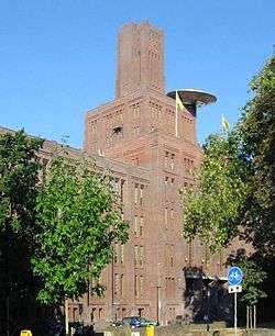
Production industry constitutes a small part of the economy of Utrecht. The economy of Utrecht depends for a large part on the several large institutions located in the city. It is the centre of the Dutch railroad network and the location of the head office of Nederlandse Spoorwegen. ProRail is headquartered in The De Inktpot (The Inkpot) – the largest brick building in the Netherlands (the "UFO" featured on its façade stems from an art program in 2000). Rabobank, a large bank, has its headquarters in Utrecht.
A large indoor shopping centre Hoog Catharijne is located between Utrecht Centraal railway station and the city centre. The corridors are treated as public places like streets, and the route between the station and the city centre is open all night. In 20 years from 2004, parts of Hoog Catharijne will be redeveloped as part of the renovation of the larger station area.[50] Parts of the city's network of canals, which were filled to create the shopping center and central station area, will be recreated. The Jaarbeurs, one of the largest convention centres in the Netherlands, is located at the west side of the central railway station.
Education
Utrecht hosts several large institutions of higher education. The most prominent of these is Utrecht University (est. 1636), the largest university of the Netherlands with 30,449 students (as of 2012). The university is partially based in the inner city as well as in the Uithof campus area, to the east of the city. According to Shanghai Jiaotong University's university ranking in 2014 it is the 57th best university in the world.[51] Utrecht also houses the much smaller University of Humanistic Studies, which houses about 400 students.[52]
Utrecht is home of one of the locations of TIAS School for Business and Society, focused on post-experience management education and the largest management school of its kind in the Netherlands. In 2008, its executive MBA program was rated the 24th best program in the world by the Financial Times.[53]
Utrecht is also home to two other large institutions of higher education: the vocational university Hogeschool Utrecht (37,000 students),[54] with locations in the city and the Uithof campus, and the HKU Utrecht School of the Arts (3,000 students).
There are many schools for primary and secondary education, allowing parents to select from different philosophies and religions in the school as is inherent in the Dutch school system.
Culture
Utrecht city has an active cultural life, and in the Netherlands is second only to Amsterdam.[6] There are several theatres and theatre companies. The 1941 main city theatre was built by Dudok. Besides theatres there is a large number of cinemas including three arthouse cinemas. Utrecht is host to the international Early Music Festival (Festival Oude Muziek, for music before 1800) and the Netherlands Film Festival. The city has an important classical music hall Vredenburg (1979 by Herman Hertzberger). Its acoustics are considered among the best of the 20th-century original music halls. The original Vredenburg music hall has been redeveloped as part of the larger station area redevelopment plan and in 2014 has gained additional halls that allowed its merger with the rock club Tivoli and the SJU jazzpodium. There are several other venues for music throughout the city. Young musicians are educated in the conservatory, a department of the Utrecht School of the Arts. There is a specialised museum of automatically playing musical instruments.
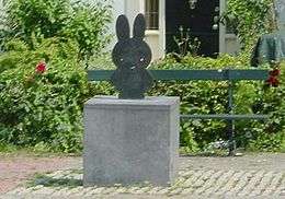
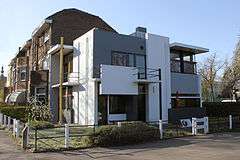
There are many art galleries in Utrecht. There are also several foundations to support art and artists. Training of artists is done at the Utrecht School of the Arts. The Centraal Museum has many exhibitions on the arts, including a permanent exhibition on the works of Utrecht resident illustrator Dick Bruna, who is best known for creating Miffy ("Nijntje", in Dutch). Although street art is illegal in Utrecht, the Utrechtse Kabouter, a picture of a gnome with a red hat, became a common sight in 2004.[55] Utrecht also houses one of the landmarks of modern architecture, the 1924 Rietveld Schröder House, which is listed on UNESCO's world heritage sites.
Every Saturday a paviour adds another letter to The Letters of Utrecht, an endless poem in the cobblestones of the Oude Gracht in Utrecht. With the Letters, Utrecht has a social sculpture as a growing monument created for the benefit of future people.
To promote culture Utrecht city organizes cultural Sundays. During a thematic Sunday several organisations create a program, which is open to everyone without, or with a very much reduced, admission fee. There are also initiatives for amateur artists. The city subsidises an organisation for amateur education in arts aimed at all inhabitants (Utrechts Centrum voor de Kunsten), as does the university for its staff and students. Additionally there are also several private initiatives. The city council provides coupons for discounts to inhabitants who receive welfare to be used with many of the initiatives.
Sports

Utrecht is home to the premier league (professional) football club FC Utrecht, which plays in Stadium Nieuw Galgenwaard. It is also the home of Kampong, the largest (amateur) sportsclub in the Netherlands (4,500 members), SV Kampong.[56] Kampong features field hockey, association football, cricket, tennis, squash and boules. Kampong's men and women top hockey squads play in the highest Dutch hockey league, the Rabohoofdklasse. Utrecht is also home to baseball and softball club UVV, which plays in the highest Dutch baseball league: de Hoofdklasse. Utrecht's waterways are used by several rowing clubs. Viking is a large club open to the general public, and the student clubs Orca and Triton compete in the Varsity each year.
In July 2013, Utrecht hosted the European Youth Olympic Festival, in which more than 2,000 young athletes competed in nine different olympic sports. In July 2015 Utrecht hosted the Grand Départ and first stage of the Tour de France.[57]
Museums
Utrecht has several smaller and larger museums. Many of those are located in the southern part of the old town, the Museumkwartier.
- Aboriginal Art Museum,[58] located at the Oudegracht this museum has a small exhibit of Australian Aboriginal Art
- Centraal Museum, located in the MuseumQuarter this municipal museum has a large collection of art, design, and historical artifacts
- Dick Bruna huis,[59] art of Centraal Museum on this separate location is dedicated to Miffy creator Dick Bruna
- Duitse Huis has a collection of historical items including many charters with seals dating from as far back as the early 13th century and a collection of medieval coins.[60]
- Museum Catharijneconvent, Museum of the Catholic Church shows the history of Christian culture and arts in the Netherlands
- Museum Speelklok National Museum in the centre of the city, displays several centuries of mechanical musical instruments
- Railroad Museum Railroad sponsored museum on the history of the Dutch railroads
- Utrecht Archives,[61] are located at Hamburgerstraat 28 in Utrecht
- Utrecht university museum[62] Utrecht University museum includes the ancient botanical garden
- Volksbuurtmuseum Wijk C[63]
- Sonnenborgh Observatory[64] observatory and museum that regularly hosts lectures on astronomy, located at Zonnenburg 2 in Utrecht
- Betje Boerhave Museum[65] museum for the grocer's shop where you can still buy old-fashioned food and non-food items, located at Hoogt 6 in Utrecht
Music and events
The city has several music venues such as TivoliVredenburg, Tivoli De Helling, ACU, EKKO, DBs and RASA. Utrecht hosts the yearly Utrecht Early Music Festival – Festival Oude Muziek Utrecht.[66] In Jaarbeurs it hosts Trance Energy. Every summer there used to be the Summer Darkness festival, which celebrated goth culture and music.[67] In November the Le Guess Who? festival, focused on indie rock, art rock and experimental rock, takes place in many of the city's venues.
Theatre
There are two main theaters in the city, the Theater Kikker[68] and the Stadsschouwburg Utrecht[69] De parade, a travelling theatre festival performs in Utrecht in summer.The city also hosts the yearly Festival a/d Werf which offers a selection of contemporary international theatre, together with visual arts, public art and music.
Notable people from Utrecht

- See also the category People from Utrecht
Over the ages famous people have been born and raised in Utrecht. Among the most famous Utrechters are:
- Pope Adrian VI (1459–1523) – head of the Catholic Church
- Louis Andriessen (1939) – composer
- Marco van Basten (1964) – football player
- Dick Bruna (1927) – writer, illustrator (Miffy)
- C.H.D. Buys Ballot (1817–1890) – meteorologist (Buys-Ballot's law)
- Theo van Doesburg (1883–1931) – painter, artist (De Stijl movement)
- Karel Doorman (1889–1942) – Rear Admiral (Battle of the Java Sea)
- Paul Fentener van Vlissingen (1941–2006) – businessman and philanthropist
- Anton Geesink (1934–2010) – judoka, first non-Japanese worldchampion Judo
- Rijk de Gooyer (1925–2011) – actor, writer, comedian and singer
- Sylvia Kristel (1952–2012) – actress Emmanuelle
- Gerrit Rietveld (1888–1964) – designer, architect (De Stijl movement)
- Herman van Veen (1945) – actor, musician, singer/songwriter and author Alfred J. Kwak
- Dafne Schippers (1992) - Sprinter/heptathlon Olympian
International relations
Twin towns
Utrecht is twinned with:
 León, Nicaragua
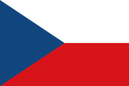 Brno, Czech Republic[70][71]
 Pekanbaru, Indonesia
- previously
 Hannover, Germany, between 1970 and 1976
Other relations
 Portland, Oregon, as a friendship city[72]
See also
| Wikimedia Commons has media related to Utrecht (city). |
Notes
- ↑ See Utrecht sodomy trials § Legacy for the history of these demonyms.
- ↑ Almost all other canal cities in The Netherlands (such as Amsterdam and Delft) have the water in canals bordering directly to the road surface
References
- ↑ "Burgemeester" [Mayor] (in Dutch). Gemeente Utrecht. Retrieved 3 April 2014.
- 1 2 Anita Bouman–Eijs; Thijmen van Bree; Wouter Jonkhoff; Olaf Koops; Walter Manshanden; Elmer Rietveld (17 December 2012). De Top 20 van Europese grootstedelijke regio's 1995–2011; Randstad Holland in internationaal perspectief [Top 20 of European metropolitan regions 1995–2011; Randstad Holland compared internationally] (PDF) (Technical report) (in Dutch). Delft: TNO. Retrieved 25 July 2013.
- ↑ "Postcodetool for 3512GG". Actueel Hoogtebestand Nederland (in Dutch). Het Waterschapshuis. Retrieved 3 April 2014.
- ↑ "Bevolkingsontwikkeling; regio per maand" [Population growth; regions per month]. CBS Statline (in Dutch). CBS. 26 June 2014. Retrieved 24 July 2014.
- ↑ "Bevolkingsontwikkeling; regio per maand" [Population growth; regions per month]. CBS Statline (in Dutch). CBS. 26 June 2014. Retrieved 24 July 2014.
- 1 2 Gemeente Utrecht. "Utrecht Monitor 2007" (PDF) (in Dutch). Retrieved 6 January 2008.
- ↑ "Gemeente Utrecht, Geschiedenis Utrecht voor 1528".
- 1 2 3 4 5 6 7 8 9 de Bruin, R.E.; Hoekstra, T.J.; Pietersma, A. (1999). Twintig eeuwen Utrecht, korte geschiedenis van de stad (in Dutch). Utrecht: SPOU & Het Utrechts Archief. ISBN 90-5479-040-7.
- ↑ Het Utrechts Archief. "Het ontstaan van de stad Utrecht (tot 100)" (in Dutch).
- ↑ Nicoline van der Sijs (2001). Chronologisch woordenboek. De ouderdom en herkomst van onze woorden en betekenissen (in Dutch). Amsterdam/Antwerpen. p. 100. ISBN 90-204-2045-3.
- ↑ R.P.J. Kloosterman (2010). Lichte Gaard 9. Archeologisch onderzoek naar het castellum en het bisschoppelijk paleis. Basisrapportage archeologie 41 (PDF). StadsOntwikkeling gemeente Utrecht. ISBN 978-90-73448-39-1.
- ↑ van der Tuuk, Luit (2005). "Denen in Dorestad". In Ria van der Eerden; et al. Jaarboek Oud Utrecht 2005. Jaarboek Oud Utrecht (in Dutch). Utrecht: SPOU. pp. 5–40. ISBN 90-71108-24-4.
- ↑ Janssen, H.P.H. (2002). Geschiedenis van de Middeleeuwen (in Dutch) (12th ed.). Utrecht: Aula. pp. 289–296. ISBN 90-274-5377-2.
- ↑ Stöver, R.J. (1997). De Salvator- of Oudmunsterkerk te Utrecht, Stichtingsmonument van het bisdom Utrecht (in Dutch). Utrecht.
- ↑ "Janskerk Informatie". Retrieved 6 January 2008.
- ↑ "Sint Pieterskerk Utrecht". Retrieved 5 January 2008.
- ↑ Haverkate, H.M. (1985). Een kerk van papier. De geschiedenis van de voormalige Mariakerk te Utrecht (in Dutch). Zutphen, the Netherlands.
- ↑ Broer, C.J.C. (2000). Uniek in de stad. De oudste geschiedenis van de kloostergemeenschap op de Hohorst sinds 1050 de Sint-Paulusabdij te Utrecht (in Dutch). Utrecht.
- ↑ "Karel V" (in Dutch). Retrieved 6 January 2008.
- ↑ "Jacobikerk". Retrieved 6 January 2008.
- ↑ "Nicolaikerk". Retrieved 6 January 2008.
- ↑ "Geertekerk – Remonstrantse Gemeente Utrecht". Retrieved 6 January 2008.
- ↑ "De Utrechtse Werven" (in Dutch). Gemeente Utrecht. Retrieved 27 January 2008.
- ↑ "Historic wharf photos from the Utrecht City Archive". Utrecht City Archive. Retrieved 27 January 2008.
- ↑ Wayne Franits (2004). Dutch Seventeenth-Century Genre Painting. Yale University Press. p. 65. ISBN 0-300-10237-2.
- ↑ "Klimaattabel De Bilt, langjarige gemiddelden, tijdvak 1981–2010" (PDF) (in Dutch). Royal Netherlands Meteorological Institute. Retrieved 9 September 2013.
- ↑ "Maandrecords De Bilt" (in Dutch). Royal Netherlands Meteorological Institute. Retrieved 9 May 2016.
- 1 2 3 Gemeente Utrecht. "Utrechts onderzoek en cijfers". Retrieved 15 October 2010.
- ↑ Gemeente Utrecht. "Bevolkingspublicatie 2007" (PDF). Retrieved 20 April 2008.
- ↑ "Aartsbisdom Utrecht" (in Dutch). Retrieved 10 December 2007.
- ↑ "Katholiek Nederland" (in Dutch). Retrieved 10 December 2007.
- ↑ CBS Statline (2007). "Gemiddelde bevolking per regio naar leeftijd en geslacht / Gebieden in Nederland 2007". Retrieved 5 January 2008.
- ↑ "RonDom". Domtoren.nl. Retrieved 13 April 2011.
- ↑ "Rabobank Groep". Rabobankgroep.nl. Retrieved 13 April 2011.
- ↑ "Cultuurhistorie en Monumenten". Utrecht.nl. 4 December 1993. Retrieved 13 April 2011.
- ↑ "Wijksite Binnenstad". Utrecht.nl. 30 March 2011. Retrieved 13 April 2011.
- ↑ "Utrecht". Map21ltd.com. Retrieved 13 April 2011
- ↑ Historische Atlas van de stad Utrecht. ISBN 90-8506-189-X
- ↑ Waterliniepad (in Dutch) (1st ed.). Wandelplatform-LAW. 2004. ISBN 90-71068-61-7.
- ↑ "Kerken Kijken Utrecht | Home". Kerkenkijken.nl. Retrieved 13 April 2011.
- ↑ "Railway Gazette: Qbuzz wins Utrecht sneltram concession". Retrieved 31 October 2010.
- ↑ "Microsoft Word - Utrecht city document.doc" (PDF). Retrieved 2014-06-23.
- ↑ "Utrecht to build world's biggest bike park – for 12,500 bikes – DutchNews.nl". DutchNews.nl. Retrieved 29 March 2015.
- ↑ "Autosnelwegen.nl". Autosnelwegen.nl. Retrieved 13 April 2011.
- ↑ Clarke, Michael. "Amsterdam-Rhine Canal (canal, the Netherlands) – Britannica Online Encyclopedia". Britannica.com. Retrieved 13 April 2011.
- ↑ "Container Terminal Utrecht". Ctu.net. Retrieved 13 April 2011.
- ↑ Martijn Elsinghorst. "Rondvaart Utrecht". Vareninutrecht.nl. Retrieved 13 April 2011.
- ↑ "50 JAAR REDERIJ". Schuttevaer. Retrieved 13 April 2011.
- ↑ "Lovers Rondvaart – In Utrecht uit – de uitagenda over uitgaan restaurants in Utrecht". Inutrechtuit.nl. Retrieved 13 April 2011.
- ↑ Jubbe vd Heide. "Stationsgebied". utrecht.nl. Retrieved 29 March 2015.
- ↑ World-University-Rankings, shanghairanking.com. http://www.shanghairanking.com/World-University-Rankings/Utrecht-University.html. Retrieved 30 March 2015. Missing or empty
|title=(help) - ↑ "About the University of Humanistic Studies (Dutch)". Retrieved 25 December 2012.
- ↑ Financial Times. "FT.com". Retrieved 6 January 2008.
- ↑ Hogeschool Utrecht. "Kengetallen HU Jaarverslag". Retrieved 7 August 2012.
- ↑ "Home". weebly.com. Retrieved 29 March 2015.
- ↑ "kampong.nl". kampong.nl. Retrieved 2014-06-23.
- ↑ "Utrecht 2015: the colour of cycling – News pre-race – Tour de France 2014". Letour.fr. 2013-11-28. Retrieved 2014-06-23.
- ↑ "aamu.nl". aamu.nl. 2014-06-06. Retrieved 2014-06-23.
- ↑ "Centraal Museum Utrecht" (in Dutch). dick bruna huis. Retrieved 2014-06-23.
- ↑ "Over RDO". Ridderlijke Duitsche Orde. Retrieved 2014-06-21.
- ↑ "hetutrechtsarchief.nl". hetutrechtsarchief.nl. Retrieved 2014-07-13.
- ↑ "web.archive.org – www.museum.uu.nl". uu.nl. Archived from the original on 12 February 2008.
- ↑ Etlon (2007-09-30). "Volksbuurtmuseum wijk C". Web.archive.org. Archived from the original on 2007-09-30. Retrieved 2014-06-23.
- ↑ http://www.sonnenborgh.nl/page=site.treenode/tree=english
- ↑ http://www.kruideniersmuseum.nl/
- ↑ "OudeMuziek :: Home". Oudemuziek.nl. Retrieved 2014-06-23.
- ↑ Hartley, Brandon. "When the Goths Have Their Picnic". Another World Blog. Retrieved 10 October 2011.
- ↑ "theaterkikker.nl". theaterkikker.nl. Retrieved 2014-06-23.
- ↑ "stadsschouwburg-utrecht.nl". stadsschouwburg-utrecht.nl. Retrieved 2014-06-23.
- ↑ "City of Brno Foreign Relations – Statutory city of Brno" (in Czech). 2003 City of Brno. Retrieved 6 September 2011. External link in
|publisher=(help) - ↑ "Brno – Partnerská města" (in Czech). City of Brno. Retrieved 17 July 2009.
- ↑ "Portland, Oregon". Washington, DC, USA: Sister Cities International. Retrieved 2015-07-04.
Literature
- Lourens, Piet; Lucassen, Jan (1997). Inwonertallen van Nederlandse steden ca. 1300–1800. Amsterdam: NEHA. ISBN 9057420082.
External links
| Wikivoyage has a travel guide for Utrecht. |
Municipalities of Utrecht | ||
|---|---|---|
 | ||
| ||