A4 motorway (Netherlands)
| ||||
|---|---|---|---|---|
| Rijksweg 4 | ||||
|
Motorways in the Netherlands with A4 bolt | ||||
| Route information | ||||
|
Part of | ||||
| Maintained by Rijkswaterstaat[1] | ||||
| Length: | 119 km[2] (74 mi) | |||
| Existed: | 25 June 1938 [3] – present | |||
| Northern segment | ||||
| North end: |
| |||
| Major junctions: | ||||
| South end: |
| |||
| Southern segment | ||||
| North end: |
| |||
| Major junctions: |
| |||
| South end: |
| |||
| Location | ||||
| Provinces: | North Holland, South Holland, North Brabant | |||
| Highway system | ||||
| ||||
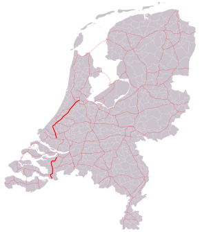
The A4 Motorway, also called Rijksweg 4, is a motorway in the Netherlands, running from Amsterdam southwards through the cities of The Hague and Rotterdam, to the Belgian border near Zandvliet, north of the city of Antwerp. The A4 is divided into two parts: the first and longest part from Amsterdam to the A15 near the city of Rotterdam. The second part starts near Heijningen, where the A29 and the A4 meets. This section travels to the Belgian border. Between the A29 near the village of Klaaswaal, south of Rotterdam, and the interchange Sabina, where the A4-A29 meets the A59, the route is numbered A29. Three European routes run concurrent with this highway at some point, E19, E30 and E312. The highway is 119 kilometres (74 mi) long.
There are no authorized plans for the missing link between Pernis (south of Schiedam and west of Rotterdam) and the A29 near Klaaswaal, though right-of-way has been acquired for the future A29 interchange with the A4.
Route description
Amsterdam to Rotterdam
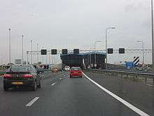
The A4 begins in the province of North Holland in the southeastern part of the city of Amsterdam at a directional T-interchange, called Knooppunt De Nieuwe Meer, with the orbital road A10, E 19 changes road from the A10 that arrives from the east onto A4, and at this interchange, the E 22 starts its run to the north concurrent with A10. Even though A4 starts at this interchange on A10, A4 has priority from the eastern direction toward this interchange as entering onto A4 from the east does not require a turn, in contrast to staying on A10 which requires a turn to the right. From the north, staying on the A10 and entering A4 both require a turn. From the interchange De Nieuwe Meer, the road travels to the southeast, concurrent with some train tracks that run in between both directions of this motorway. After some 4 kilometers, the road intersects A9 at the partial cloverleaf interchange Badhoevedorp. After leaving this interchange, the concurrent train tracks travels underground southwards towards Amsterdam Airport Schiphol. The A4 continues its route towards Schiphol and by doing so enters the 650 meter long Schiphol tunnel underneath an airplane runway and two taxiways. Exit 2 of this motorway serves the airport. Hereafter, another taxiway bridges crosses the A4. Southeastern of Schiphol, A5 joins the A4 at an incomplete interchange De Hoek. This interchange does not have a ramp from the A5 to the northbound lane of the A4, because the A9 already serves getting traffic from A5 to A4 in both directions. Shortly before leaving the province of North Holland and entering South Holland, the A44 branches off the A4 at the interchange Burgerveen. This interchange is incomplete as well as you can only travel onto the A44 from Amsterdam. The road crosses the Ringvaart, using aqueduct the Ringvaartaquaduct, and so enters South Holland. From here, the train tracks went underground, shortly before Schiphol join the A4 again and runs concurrent with the A4 up to exit 6. At the municipality line between Leiderdorp and Leiden, the road uses aqueduct the Limesaquaduct to travel under the river the Oude Rijn. The A4 now approaches The Hague. In the Vinex-location Leidschenveen-Ypenburg in the municipality of The Hague, the motorway gets to stack interchange Prins Clausplein with the A12 and the E 30 and interchange Ypenburg with the A13 and the E 19. From the first of the two interchanges, the E 30 joins the A4 from the A12 from the east. At the second interchange, the E 30 (A13) continues to run concurrent with the A4, a motorway that starts at this interchange and connects The Hague with Rotterdam as well. In between these two interchanges the A4, the E 19 and the E 30 all run concurrent and on this location, there is a basketweave exchange. The outerlanes of the basketweave are for connecting the A13 and the stack exchange ramps from and to the A12, the inner lanes are the continuing the A4. Leaving the basketweave interchange, the A4, now concurrent with the E 30, continues southwards around Delft towards southeastern Delft, where it continues partially below ground level through the Midden-Delfland region. It then enters the Rotterdam region at a semi-directional T-interchange, called Kethelplein, where the motorway travels to the south while the A20 concurrents with the E 25, travels from the east to the west. When traveling under some train tracks, the road approaches exit 16, which allows access to east Vlaardingen, as well as west Schiedam. This exit is special as the northern exit and southern entrance first travels parallel with the A4 through the Beneluxtunnel under the river Nieuwe Maas. This also results in more lanes for drivers to use, which helps diminish traffic congestion, since the ramps connects to the A4 on the southern side of the Nieuwe Maas. They shortly after branch off and enter interchange Benelux, an incomplete T-interchange with only a southbound exit and a northbound entrance, named 17a as to not confuse drivers since the previous exit on A15 to the west is already exit 17. This interchange is the southern terminus of this segment of the A4 and the road continues both west and east as the A15.
Heijningen to the Belgian border
The final segment of the A4 with the A29, starts in the province of North Brabant near Heijningen at the interchange Hellegatsplein, crossing the estuaries Hollands Diep (to the east), Haringvliet and the Volkerak (to the west). Shortly hereafter, the A4 enters the trumpet interchange Sabina with the motorway A59. This intersection is named after a fort that was built nearby. The A29 and the A59 both enter this interchange from the north and the A29 ends here. The A4 continues to the south, while the A59 branches off to the east. Crossing the Dintel and passing by Dinteloord, the road makes a large curve to the west and subsequently continues to the south, forming a tangent around Steenbergen. In the southern part of the curve, the A4 travels along Fort Henricus, a now demolished fort with only the shape of the land intact. Here, the road also tunnels under the Steenbergse Haven, using the third aqueduct of the motorway A4, aqueduct Steenbergen aan Zee. The A4 continues southbound and passes Bergen op Zoom to the east, with a few exits serving this city. Between exits 27 and 28, the A58 concurrents with the E 312 join A4 to the south. All three roads travel concurrently southbound and at trumpet interchange Markiezaat, the A58 and the E 312 both leave the A4 and travel to the west, entering the province of Zeeland. The A4 however travels its final kilometers to the south until reaching the Belgian border near Zandvliet. A few meters before crossing the border, the northbound entrance and southbound exit ramps start on Dutch soil, the rest off this exit is positioned on Belgian soil and is part of the Belgian A12.
History
In the 1930s work had started on the predecessors of A4. These roads followed the current route quite accurately and were of relatively high standards. Late 1930s various parts were put into use, among others a road between Amsterdam and Sassenheim. This route is not used by the current A4 anymore. In 1938 ground was bought for the construction of rijksweg 4A from Burgerveen to Leidschendam. This would later be renumbered to rijksweg 4, of which A4 is a part. Ground work began in 1939 near Leischendam, but were cancelled in 1942 due to World War 2. In that same year construction on interchange Ypenburg had also started. In 1957 A4 was opened between interchange Ypenburg and the then called interchange Leidschendam, nowadays known as interchange Prins Clausplein, with 2 lanes in both directions. Construction from the latter interchange further north up to Hoogsmade was being worked on in 1958. In 1960 and 1961 the section between interchange Burgerveen and Hoogsmade was opened, including an aqueduct underneath river Ringvaart, aqueduct Ringvaartaquaduct. Going to the south, one lane of a separate section of rijksweg 4 between Klaaswaal and interchange Hellegatsplein was opened in 1964, and in 1965 another lane was added, this part is currently designated as A29. A year later in 1966 another stand-alone section of A4 was opened with 3 lanes in each direction between Amsterdam where interchange Badhoevedorp is now located and Hoofddorp, leaving a gap between Hoofddorp and interchange Burgerveen. Interchange Badhoevedorp which is between Amsterdam and Hoofddorp was opened a year later in 1967, which was the first cloverleaf interchange with collector/distributor lanes in the Netherlands. In 1972 this segment of A4 was lengthened northward to connect to interchange De Nieuwe Meer. Another not connected part of A4 was being constructed between interchange Kethelplein en Pernis in 1967 in western Rotterdam. This included the construction of the Beneluxtunnel which tunneled under river Nieuwe Maas and used to be a tolled tunnel. In 1972 this section was extended southward to interchange Benelux. In 1980 the tolling in the Beneluxtunnel was put to an end. In 1971 the part of rijksweg 4 that was designated A29 was extended from interchange Hellegatsplein to Dinteloord, it was first administratively and publicly known as rijksweg 19 but in 1976 renumbered to rijksweg 4 and designated as A29. Another section of rijksweg 4 concurrent with A58 was opened around Bergen op Zoom between 1973 and 1976. In 1985 interchange Leidschendam was renamed and redesigned to a 4-level stack interchange Prins Clausplein, as we know it today. In 1993 the section around Bergen op Zoom was extended from interchange Markiezaat, where concurrency with A58 stopped, to the south to the Belgian border near the Belgian city Zandvliet where it connected to the Belgian A12. In 1999 the section between The Hague-Zuid and Delft-Zuid opened for traffic, after the section between interchange Ypenburg and The Hague-Zuid was opened with 3 lanes in each direction in 1998. The segment between Badhoevedorp and Hoofddorp has been widened to 2x4 lanes in 1988, and ten years later in 1998, the tubes in the Schipholtunnel were renewed. In 2003 a new express lane was added to both directions between Hoofddorp and interchange Burgerveen, giving this segment a total of 2x5 lanes. As of 2 April 2013, these express lanes are permanently opened, and not only during rush hours.[4] In 1998 A4 between Zoeterwoude and Leidschendam was widened to 2x3 lanes and in 1999 the part between Leidschendam and interchange Prins Clausplein was widened to 2x5 lanes. In 2006 the segment between Hoogmade and Roelafarendsveen was widened to 2x3 lanes. In 1997 construction had started on the second Beneluxtunnel in Rotterdam. On 11 Mei, 2002, this project was completed with 4x2 lanes and a reversible lane, making 5 lanes available in the peak direction. Between interchanges De Nieuwe Meer and Badhoevedorp in southwestern Amsterdam, express lanes were added in 2011 to relief the 2x3 lanes on this segment of the A4 during rush hours, because of the 180 thousand vehicles traveling over this part of the road every day. Construction on this was started in summer 2010. In 2010 construction also started on adding parallel lanes to both directions of A4 between Hoofddorp and Hoofddorp-Zuid for the purpose of the construction of the realigned N201, commissioned by the province of North Holland. These parallel lanes are between rest area Den Ruygen Hoek and exit Schiphol. Work was completed on 15 December 2013. Entering interchange Burgerveen from the North, A4 has 2x5 lanes, and after leaving this interchange it only has 2x2 lanes. Even though a lot of traffic is going to A44 at this interchange this was still an important bottleneck with some 100 thousand vehicles every day in aqueduct Ringvaartaquaduct that also didn't have emergency lanes. Further south, the bridge over river Oude Rijn was another bottleneck with also only 2x2 lanes. After this 2x3 lanes were once again available. Back in 2005, the lane toward Amsterdam was already widened to three lanes between Hoogmade and Roelfarendsveen, a year later, a lane was added to the other direction. The low bridge over river Oude Rijn has been replaced by aqueduct Limesaquaduct, making A4 deeper over 1400 meter. A second aqueduct at the Ringvaartaquaduct was also constructed near Roelfarendsveen, which was opened on 31 July 2010, after which the existing aqueduct from 1961 was renovated. On 24 November 2010, the 2x3 lanes were opened, which meant the end of traffic jams. This aqueduct was formally opened by minister Schultz.[5] The opening of aqueduct Limesaquaduct was in two phases. At first the first aqueduct was opened in 2012 next to the existing A4, almost immediately with 2x3 narrowed lanes, after which the old A4 was destroyed and the construction of the second aqueduct was started. On 25 October 2014, the second aqueduct opened. The aqueduct has a space reservation for 2x5 lanes with emergency lanes. As of 1 December 2014, the widening is fully finished, when the aqueduct toward The Hague was appointed with three lanes with normal width.
Delft - interchange Kethelplein missing link
Until 2015, southwest of Delft A4 had its southern terminus of the section that starts in Amsterdam. Another section started at interchange Kethelplein in Schiedam and runs southwards. The missing segment caused huge congestion on the adjacent parallel A13, which was the only road motorway connecting The Hague and Rotterdam. There have been plans for creating this missing link in the past but the government diverted finances to other projects twice. In 2006 it was estimated that this 7 kilometer missing section would cost 700 million euros, and in 2009 the Dutch government decided that this section would be constructed. On 2 September 2010, minister Camiel Eurlings made a record of decision for this road segment, and on 6 July 2011 all appeals against the record of decision were dismissed. In autumn 2011, construction began. The missing link was completed in late 2015 and was opened on 18 December 2015 (northbound) and 20 December 2015 (southbound).[6][7]
Dinteloord - Halsteren missing link
The section between Dinteloord and Halsteren until 2015 was the latest missing link of A4 that was constructed. It connects the south end of A29 with another segment of A4 that was already constructed near Bergen op Zoom. The construction of this missing link relieved A16 and A17 from its constant traffic jams near Dordrecht, the Moerdijk bridge and Bergen op Zoom since this was the main and only considerably fast motorway for traveling from major Dutch cities like The Hague and Rotterdam toward the cities of Antwerp and Brussels in Belgium. Finances for the 16 kilometer long missing link were first saved in 2005, consisting of a budget of 218 million euros. In 2006 construction of A4 near Halsteren was awarded to construction companies and in 2007 the government decided A4 would be constructed west of Steenbergen, which would require creating an aqueduct under canal Steenbergsche Haven. A road east of Steenbergen would have been much shorter and cheaper but it would have traversed right through the Mark river area, which was opposed by many since it is seen as an important natural aspect in the region. The first segment of the missing link, the so-called Halsteren bypass, was opened in December 21, 2007 by Minister of Transport Camiel Eurlings. This bypass consists of a 4 kilometer long extension from the existing southern section of A4 northwards from exit 27 to provincial road N286 north of the town Halsteren to relieve provincial road N259 through that same town. By the end of 2010, construction had begun, and it was planned that the road would have been finished by the end of 2013. On 14 March 2012 the new segment of highway around Steenbergen was officially approved by the Dutch Council of State. On 18 June 2012 another small extension was added to the southern segment of A4, a 1,5 kilometer long highway linking Halsteren and Klutsdorp. By the end of December 2013, the final segment around Steenbergen between Klutsdorp and A29 near Dinteloord was completed, which created a continuously running link between Rotterdam and the Belgian border over A29 and A4.
Future
Due to the rearrangement of the A9 near Badhoevedorp, interchange Badhoevedorp with the A4 will also be altered. The new arrangement is supposed to make the A9 travel around Badhoevedorp in the shape of an arc, which means the arrangement of the interchange will have to change. The construction of this has been started in December 2013 and is planned to be done in 2017. Because of the construction of the Rijnlandroute, which will be designated as the N434, the parallel structure near Zoeterwoude will have to be lengthened even further southward up to interchange Hofvliet with the Rijnlandroute. On 9 May 2014, the draft of the planning procedure was made available for inspection,[8] followed by the real planning procedure on 17 December 2014. Construction on this will according to the plan be started in 2015. The A4 will be widened to 2x4 lanes between the new interchange Hofvliet and exit Leidschendam. To allow this only the southern direction has to get a wider pavement, because there is already an emergency lane present northward. Costs are estimated at 11,3 million euros. On 26 September 2013, the decision to start was made [9] and on 11 July 2014, the draft planning procedure was shown,[10] followed by the final planning procedure on 18 December 2014. [11] The widening is planned to be complete around 2020. There are plans to allow more capacity between Leidschendam and The Hague-Zuid due to the traffic congestion between interchanges Ypenburg and Prins Clausplein, because of the development of the regions Rotterdam and The Hague. There are also plans for the A4 to make the city of The Hague less reliant on the Utrechtsebaan.[12] On 15 May 2012, the draft rijksstructuurvisie was determined [13] and on 21 November 2012, the final rijksstructuurvisie followed. Plans are to change this part of the A4 between 2020 and 2023. [14]
Interchange Benelux - Klaaswaal missing link
At this point in time, there is no motorway between interchange Benelux and the A29 near Klaaswaal. Interchange Benelux, however, is constructed so an extension of the A4 southwards is possible without changing the layout of the interchange. This missing section was already approved by the government in 1961, as part of the then called road 19, and in 2005 space was reserved in the mobility vision of the government. By constructing this missing link, the A4 would be one continuously running road from interchange Kethelplein, west of the city of Rotterdam, to the Belgian border. It would also relieve the motorways A15 and A29 from traffic jams, since they now serve as a link between the two sections of the A4. Supporters of creating this 12-kilometer long motorway state that cities like Hoogvliet, Spijkenisse, Barendrecht and Rotterdam would be a lot less congested, and that the overall traffic flow would be restored. Opposers, among which are environmentalists, state that the build of the missing link would only result in more traffic and thus more congestion and this would harm the environment. Since the A15 and the A29 are currently being widened, this section of the A4 seems more and more unlikely to be built.
The motorway section between Klaaswaal and interchange Sabina near Dinteloord is currently known and designated as the A29, but the intention is to include it in the A4 motorway and designate it as such in the future. When the missing link between interchange Benelux and Klaaswaal is completed, this section will be renumbered to A4, in order to create a continuously numbered motorway between interchange Kethelplein and the Belgian border. For now, however, this section of road is still being numbered as 'A29', to avoid confusion with motorists.
Exit list
| Country | Province | Municipality | km | mi | Exit | Destinations | Notes |
|---|---|---|---|---|---|---|---|
| Netherlands | North Holland | Amsterdam | 0 | 0.0 | — | Northern terminus of northern segment of the A4; north end of E19 overlap | |
| 2 | 1.2 | 1 | Anderlechtlaan | ||||
| Haarlemmermeer | 4 | 2.5 | — | ||||
| 7 | 4.3 | 2 | Ceintuurbaan Zuid / Westelijke Randweg / Schiphol Boulevard | ||||
| 11 | 6.8 | — | Northbound exit and southbound entrance only | ||||
| 11 | 6.8 | 3 | |||||
| 18 | 11 | 4 | |||||
| 18 | 11 | — | Southbound exit and northbound entrance only | ||||
| South Holland | Alkemade | 23 | 14 | 5 | Provincialeweg / Veenderveld / Alkemadelaan to Roelofarendsveen | ||
| Jacobswoude | 29 | 18 | 6 | ||||
| Zoeterwoude | 33 | 21 | 6a | ||||
| 35 | 22 | 7 | |||||
| Leidschendam-Voorburg | 44 | 27 | 8 | ||||
| 46 | 29 | — | North end of E30 overlap | ||||
| The Hague | 47 | 29 | — | Southbound entrance through intersection with traffic lights; south end of E19 overlap | |||
| Rijswijk | 48 | 30 | 9 | Laan van Delfvliet to Rijswijk | |||
| 49 | 30 | 10 | Diepenhorstlaan northwest to Rijswijk | ||||
| 51 | 32 | 11 | Pr. Beatrixlaan to Rijswijk / Delft | ||||
| The Hague | 53 | 33 | 12 | South end of E30 overlap | |||
| Midden-Delfland | 55 | 34 | 13 | ||||
| Delft | 57 | 35 | 14 | ||||
| Schiedam | 70 | 43 | — | ||||
| Vlaardingen | 72 | 45 | 16 | Vlaardingerdijk / Schiedamsedijk to Vlaardingen-Oost / Schiedam-West | |||
| Rotterdam | 75 | 47 | 17 | Gaderingviaduct/ Hoefsmidstraat / Vondelingenweg to Poortugaal / Hoogvliet / Pernis | Northbound entrance and southbound exit only | ||
| 76 | 47 | — | Southern terminus of middle segment of A4 | ||||
| Benelux-Klaaswaal gap | |||||||
| Cromstrijen | 23– 90 | 14– 56 | — | North end of A29 road designation; A29 also continues further northeastward, separate from future A4 towards interchange Benelux | |||
| 93 | 58 | 22 | |||||
| Goeree-Overflakkee | 99 | 62 | — | North end of A59 overlap | |||
| North Brabant | Moerdijk | 102 | 63 | 23 | Maltaweg to Willemstad | ||
| 210– 104 | 130– 65 | — | South end of A29 road designation; south end of A59 overlap | ||||
| Steenbergen | 215 | 134 | 24 | ||||
| 223 | 139 | 25 | |||||
| Bergen op Zoom | 229 | 142 | 26 | ||||
| 233 | 145 | 27 | Randweg Noord west to Bergen op Zoom-Noord | ||||
| 234 | 145 | — | North end of E312 and A58 overlap | ||||
| 235 | 146 | 28 | Rooseveltlaan west to Bergen op Zoom | ||||
| 236 | 147 | 29 | Huijbergsebaan to Bergen op Zoom-Zuid | ||||
| Woensdrecht | 241 | 150 | 30 | ||||
| 243 | 151 | — | South end of E312 and A58 overlap | ||||
| North Brabant-Antwerp province line | Woensdrecht-Antwerp municipality line | 250 | 160 | 11 | Only start of northbound entrance and southbound exit on Dutch soil, other parts on Belgian soil | ||
| 251 | 156 | — | Border with Belgium; this road continues as the Belgian A12 | ||||
1.000 mi = 1.609 km; 1.000 km = 0.621 mi
| |||||||
See also
- List of motorways in the Netherlands
- List of E-roads in the Netherlands
 Netherlands portal
 Roads portal
References
- ↑ "Wegbeheerders". Rijkswaterstaat. Retrieved 14 December 2014.
- ↑ "A4". Rijkswaterstaat. Retrieved 26 June 2015.
- ↑ "Dossier A4". Autosnelwegen.nl. Retrieved 27 June 2015.
- ↑ "Permanente openstelling spitsstroken A4". Rijkswaterstaat. 2013-04-02. Retrieved 2015-07-01.
- ↑ "Laatste bottleneck A4 veel eerder opgelost | Nieuwsbericht". Rijksoverheid.nl. Retrieved 2015-07-01.
- ↑ "A4". Rijkswaterstaat. Retrieved 26 June 2015.
- ↑ van der Aa, Edwin (17 December 2015). "A4: na 50 jaar gesteggel gaat de weg morgen open". Algemeen Dagblad (in Dutch). De Persgroep Digital. Retrieved 17 December 2015.
- ↑ "Ontwerp-tracébesluiten Rijnlandroute ter visie | Nieuwsbericht". Rijksoverheid.nl. 2014-05-09. Retrieved 2015-07-01.
- ↑ "Startbeslissing Verbreding A4 Vlietland - N14 | Convenant". Rijksoverheid.nl. 2013-09-26. Retrieved 2015-07-01.
- ↑ "Ontwerptracébesluit A4 Vlietland-N14 ter visie". Rijkswaterstaat. Retrieved 2015-07-01.
- ↑ "Platform Participatie - Tracébesluit". Platformparticipatie.nl. Retrieved 2015-07-01.
- ↑ "Beschrijving inrichting van de voorgenomen rijksstructuurvisie A4 passage en Poorten en Inprikkers in het kader van de MIRT Verkenning Haaglanden | Kamerstuk". Rijksoverheid.nl. 2010-12-16. Retrieved 2015-07-01.
- ↑ "Ontwerp-Rijksstructuurvisie A4 Passage en Poorten & Inprikkers | Kamerstuk". Rijksoverheid.nl. 2012-05-15. Retrieved 2015-07-01.
- ↑ "Akkoord over forse verbetering bereikbaarheid regio Den Haag | Nieuwsbericht". Rijksoverheid.nl. Retrieved 2015-07-01.
External links
![]() Media related to A4 motorway (Netherlands) at Wikimedia Commons
Media related to A4 motorway (Netherlands) at Wikimedia Commons