Admiralty Island National Monument
| Admiralty Island National Monument | |
|---|---|
|
IUCN category III (natural monument or feature) | |
|
Windfall Harbor | |
 | |
| Location | Hoonah-Angoon Census Area and Juneau, Alaska, United States |
| Nearest city | Juneau, AK |
| Coordinates | 57°37′05″N 134°09′40″W / 57.61806°N 134.16111°W[1]Coordinates: 57°37′05″N 134°09′40″W / 57.61806°N 134.16111°W[2] |
| Area | 955,747 acres (3,867.77 km2) |
| Governing body | U.S. Forest Service |
| Website | http://www.fs.usda.gov/tongass/ |
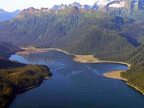
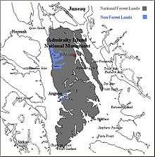
Admiralty Island National Monument is a United States National Monument located on Admiralty Island in Southeast Alaska, and is managed as part of the Tongass National Forest. It was created December 1, 1978, and covers 955,747 acres (3,868 km2) in Southeast Alaska. The remoteness of the monument led Congress to pass legislation designating all but 18,351 acres (74 km2) of the monument as the Kootznoowoo Wilderness, ensuring that the vast bulk of this monument is permanently protected from development. The monument is administered by the U.S. Forest Service from offices in Juneau.
Western hemlock, Sitka spruce and western redcedar dominate the prolific rainforest vegetation; wildlife in abundance includes brown bear, bald eagles, many species of salmon, whales, and deer. It has more brown bears than the entire lower 48 states, and one of the highest densities of bald eagles in the world.[3]
Cultural resources include the remains of fish canneries, whaling stations and mining cabins that attest to the island's early history of development.[4]
The national monument is considered sacred space to the Angoon Tribe of Tlingit people, who live on tribal land in the community of Angoon on the western coast of the island. The Tlingits fought to make protection for the island a part of ANILCA legislation, and continue to engage in stewardship of the island's natural resources. Most of Angoon's residents make daily subsistence use of the national monument.[4] The 32-mile Cross Admiralty Canoe Route is a popular destination for backcountry canoeing and kayaking, traversing the breadth of the island through a series of lakes, streams and trail portages, with several cabins and shelters along the way.[5] While the modern route was laid out and constructed by the Civilian Conservation Corps in the 1930s, it follows traces long used by the island's native inhabitants for hunting, fishing and trading.[6]
The Greens Creek Mine is an underground silver, gold, zinc and lead mine located on the northwest end of the island, within the national monument but outside of the wilderness area. It began operation in 1989. Acid mine drainage has occurred at the mine site.

References
- ↑ "Admiralty Island National Monument". Geographic Names Information System. United States Geological Survey. Retrieved November 18, 2013.
- ↑ "Admiralty Island National Monument". Geographic Names Information System. United States Geological Survey. Retrieved November 18, 2013.
- ↑ Admiralty Island National Monument, United States Forest Service.
- 1 2 Admiralty Island National Monument/Kootznoowoo Wilderness, USDA Forest Service, MB-R10-190. (1992)
- ↑ Cross Admiralty Canoe Route, SEATrails.
- ↑ Civilian Conservation Corps Properties in Alaska Archived August 20, 2014, at the Wayback Machine., Alaska Department of Natural Resources.
External links
| Wikimedia Commons has media related to Admiralty Island National Monument. |
- "Admiralty Island National Monument". Tongass National Forest. U.S. Forest Service. Archived from the original on 5 August 2006. Retrieved 2006-08-13.
- "Tongass National Forest". U.S. Forest Service. Archived from the original on 10 August 2006. Retrieved 2006-08-13.