Aguascalientes City
| Aguascalientes | |||
|---|---|---|---|
| City | |||
| Ciudad de Aguascalientes City of Aguascalientes | |||
|
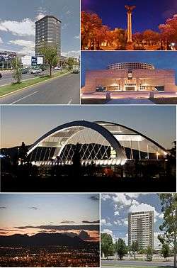
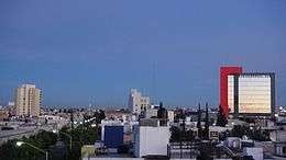
Clockwise from top: Plaza Bosques Tower, La Exedra, Aguascalientes Theatre, Puente Bicentenario, Cerro del Muerto and Terzetto Residential Tower. | |||
| |||
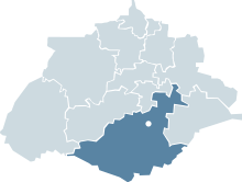 Location of Aguascalientes within the state | |||
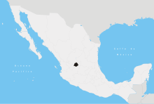
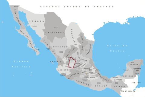
 Location of the state of Aguascalientes | |||
| Country | Mexico | ||
| State | Aguascalientes | ||
| Municipality | Aguascalientes | ||
| Founded | 22 October 1575 | ||
| Government | |||
| • Mayor | Juan Antonio Martín del Campo | ||
| Area | |||
| • City | 385 km2 (149 sq mi) | ||
| Elevation | 1,888 m (6,194 ft) | ||
| Population (2012) | |||
| • City | 934,424 | ||
| • Density | 2,400/km2 (6,300/sq mi) | ||
| • Metro | 1,225,432 | ||
| Demonym(s) | Hidrocálido, Aguascalentense | ||
| Time zone | CST (UTC−6) | ||
| • Summer (DST) | CDT (UTC−5) | ||
| Postal code | 20000-20999 | ||
| Area code(s) | 449 | ||
| Website | http://www.ags.gob.mx | ||


Aguascalientes (Spanish pronunciation: [aɣwaskaˈljentes]) is the capital of the state of Aguascalientes and is its most populous city, with a metropolitan population of 1,000,000.[1] It is located in North-Central Mexico. It is part of the macroregion of Bajío,[2] which is among the safest and most prosperous regions in Mexico.[3] Aguascalientes has repeatedly been recognized as one of the cities with the best quality of life in Latin America.[3][4] Nowadays, Aguascalientes is a vigorous service city that is experiencing an ongoing social, economic, and aesthetic revitalization process.[5]
It stands on the banks of the Aguascalientes river, 1880 meters above sea level, at 21°51′N 102°18′W / 21.850°N 102.300°W. It is the municipal seat for the Aguascalientes Municipality. The Aguascalientes metropolitan area includes the municipality of Jesus María and San Francisco de los Romo. It was a Chichimeca Indian territory. It later blossomed as a strategic link between Mexico City and the mines of Zacatecas, while prosperous agriculture and ranching helped feed Spain’s emerging New World cities.[6]
OECD has recognized Aguascalientes as having the best business climate standards in the world.[7] It is a strong business and economic center in the Bajío region.[8] Its strategic location and excellent infrastructure have made it a regional hub and a popular location for international headquarters.[8]
Its first-class services and hotel industry turn it into one of the most important centers in Mexico with numerous options of entertainment, gastronomy, leisure activities, arts and recreation.[9]
History
The city of Aguascalientes was founded on October 22, 1575 by Juan de Montoro as a postal service rest stop between the cities of Zacatecas and Mexico City, though it is known that the site already featured a small population by the time it was granted an official status.[10] Although its founders did not envision it becoming a major city, it became the capital of the newly formed state of the same name when its territory separated from the adjacent state of Zacatecas in 1835. When the state separated from Zacatecas, Aguascalientes raced ahead in its development, while the state of Zacatecas remained behind in comparison.
The historical center of Aguascalientes was born out of four distinct neighborhoods. The oldest of these is the Barrio del Encino, which is technically older than Aguascalientes proper. Founded in 1565 by the Andalusian Hernán González Berrocal, the neighborhood was originally named Triana after the neighborhood in Seville, Spain. The Barrio del Encino is home to the baroque-style Templo del Señor del Encino, a catholic temple built between 1773 and 1796.[11] The Cristo Negro del Encino ("Black Christ of the live oak"), is a widely venerated religious icon symbolic of this neighborhood. The colonial square and the José Guadalupe Posada Museum, adjacent to the temple, are one of the main attractions in the city.
The second neighborhood is the Barrio de San Marcos, which has its roots in the early 17th century as an indigenous settlement on the outskirts of the then-village of Aguascalientes. Between 1628 and 1688, some communal land was allocated to the community, but the indigenous people still worked on Spanish-owned farms and produced goods to sell in Aguascalientes. Meanwhile, they organized the construction of a simple hospital and a chapel. This original chapel was replaced by the current Templo de San Marcos completed on December 15, 1763; this church is the spiritual headquarters of the Feria Nacional de San Marcos that makes the neighborhood famous today.
The third neighborhood is the Barrio de Guadalupe, which began its development as a string of shops and trading posts alongside the road leading from Aguascalientes to Jalpa and Zacatecas during the latter half of the 18th century. The neighborhood's iconic Templo de Guadalupe was built between 1767 and 1789; it's recognized for its Spanish Baroque facade and its dome lined with Talavera tiles. Especially after the founding of the Fundición Central Mexicana ("Mexican Central Foundry"), the neighborhood developed quickly; by the early 20th century its roadside inns had mostly been converted into homes and its boundaries had blurred with those of the Barrio de San Marcos.
The final neighborhood is the Barrio de la Salud, which has its roots in a small chapel and a cemetery developed towards the end of the 18th century to deal with a number of disease epidemics that had struck the area. Gravediggers established homes near the cemetery, and others took advantage of the open land to establish orchards. Though the orchards began to disappear during the early 20th century, clues as to the neighborhood's roots still remain. First of all, the fact that property lines generally followed irrigation ditches can still be seen in the neighborhood's haphazard street grids today. Second, the neighborhood's working class character is visible in its primarily single-story homes featuring simple facades.[12]
A fifth neighborhood, the Barrio de la Estación, is often grouped in with the city's original neighborhoods.[13] However, this neighborhood is considerably more modern, with much of its development dating from the final decades of the 19th century or later.[14] Therefore, despite its important role in the history of Aguascalientes, it's not strictly accurate to consider the Barrio de la Estación one of the city's original historical neighborhoods.
Climate
Under the Köppen climate classification, Aguascalientes has a semi-arid climate (Köppen BSh). Most of the precipitation is concentrated from June to September.
| Climate data for Aguascalientes (1951–2010) | |||||||||||||
|---|---|---|---|---|---|---|---|---|---|---|---|---|---|
| Month | Jan | Feb | Mar | Apr | May | Jun | Jul | Aug | Sep | Oct | Nov | Dec | Year |
| Record high °C (°F) | 29.5 (85.1) |
32.0 (89.6) |
34.0 (93.2) |
36.5 (97.7) |
39.5 (103.1) |
40.0 (104) |
36.0 (96.8) |
34.0 (93.2) |
36.0 (96.8) |
32.0 (89.6) |
31.0 (87.8) |
29.5 (85.1) |
40 (104) |
| Average high °C (°F) | 22.3 (72.1) |
24.0 (75.2) |
26.5 (79.7) |
29.0 (84.2) |
30.7 (87.3) |
29.5 (85.1) |
27.3 (81.1) |
27.2 (81) |
26.3 (79.3) |
25.7 (78.3) |
24.6 (76.3) |
22.5 (72.5) |
26.3 (79.3) |
| Daily mean °C (°F) | 13.4 (56.1) |
15.0 (59) |
17.5 (63.5) |
20.3 (68.5) |
22.4 (72.3) |
22.5 (72.5) |
20.9 (69.6) |
20.8 (69.4) |
20.1 (68.2) |
18.5 (65.3) |
16.0 (60.8) |
14.0 (57.2) |
18.5 (65.3) |
| Average low °C (°F) | 4.5 (40.1) |
5.9 (42.6) |
8.5 (47.3) |
11.5 (52.7) |
14.1 (57.4) |
15.4 (59.7) |
14.6 (58.3) |
14.5 (58.1) |
13.9 (57) |
11.2 (52.2) |
7.4 (45.3) |
5.4 (41.7) |
10.6 (51.1) |
| Record low °C (°F) | −6.0 (21.2) |
−7.0 (19.4) |
−1.0 (30.2) |
1.0 (33.8) |
4.5 (40.1) |
6.0 (42.8) |
6.5 (43.7) |
9.0 (48.2) |
5.0 (41) |
0.0 (32) |
−5.5 (22.1) |
−5.0 (23) |
−7 (19.4) |
| Average rainfall mm (inches) | 14.1 (0.555) |
9.5 (0.374) |
4.3 (0.169) |
8.8 (0.346) |
17.9 (0.705) |
88.1 (3.469) |
119.9 (4.72) |
120.4 (4.74) |
90.1 (3.547) |
35.4 (1.394) |
10.3 (0.406) |
11.9 (0.469) |
530.7 (20.894) |
| Average rainy days (≥ 0.1 mm) | 2.4 | 1.5 | 1.0 | 1.6 | 3.6 | 9.7 | 13.5 | 13.2 | 9.5 | 4.9 | 1.6 | 2.2 | 64.7 |
| Average relative humidity (%) | 58 | 52 | 47 | 45 | 46 | 59 | 66 | 68 | 68 | 65 | 60 | 62 | 58 |
| Mean monthly sunshine hours | 237.6 | 238.1 | 257.9 | 249.6 | 270.4 | 227.0 | 223.6 | 231.8 | 198.9 | 231.2 | 245.6 | 213.2 | 2,824.9 |
| Source #1: Servicio Meteorologico Nacional[15] | |||||||||||||
| Source #2: Colegio de Postgraduados (sun and humidity)[16] | |||||||||||||
Name

The name originates from the Spanish words, "aguas calientes" meaning "hot waters" although a more accurate translation is "Hot Springs", part of the original name of "Villa de Nuestra Señora de la Asunción de las Aguas Calientes" (Village of our Lady of Assumption of the Hot Springs). When the city was first settled by Juan de Montoro and 12 families, it was given this name for its abundance of hot springs. These thermal features are still in demand in the city's numerous spas and even exploited for domestic use. People from Aguascalientes (both the city and the state) are known by the whimsical Spanish demonym hidrocálidos or "hydrothermal" people.
Modern day
Aguascalientes today identifies itself as at the confluence of tradition and industry. Its preserved colonial center testifies to its rich architectural heritage and cultural vision. On the other hand, the precisely planned peripheral expressways, as well as its first class avenues and lanes, are surrounded with industrial parks that employ thousands of people. The state reports a high index of migrants, especially from other states, seeking to acquire a better quality of life.
Demographics
As of 2010, the city of Aguascalientes proper had a population of 797,010. The two other municipalities considered parts of the Aguascalientes metropolitan area are Jesús María and San Francisco de los Romo; they had populations of 99,590 and 35,769 respectively. As such, the Aguascalientes metropolitan area had a total population of 932,369.[17]
According to the latest census by the National Institute of Statistics, Geography, and Data Processing (INEGI), Aguascalientes City was the 13th largest metropolitan area by population in the country. It is one of the fastest growing cities in Mexico.
The local population of Aguascalientes is 78% European descent, mostly Spanish and French with settlement of French troops in the Valley of Huajucar during the Second Mexican Empire. Many Hidrocalidos trace their lineage back to Germany and the Netherlands, due to the settlement of various Mennonite communities, but also Italian, Russian, Polish, Swedish, German, Greek, and Romanian due to the high number of refugees who came to the state during World War II. The remainder of the population: 15% mestizo (mixed Amerindian-European); 7% Asian (mostly Japanese and Korean due to the rapid growth in Nissan production with the opening of a new factory in the state).
Quality of life
%2C_Aguascalientes%2C_Ags._16.JPG)
The city had a Human Development Index of 0.82 in 2000,[18] placing it in the very high development category. Open heart surgeries and heart and kidney transplants have been performed in Aguascalientes for the past 20 years; by comparison, these same surgeries were first performed in the United States 28 years ago. The life expectancy of 76 years is similar to that which can be found in Denmark, Ireland or Portugal.
100% of the population has Medical Service Coverage. In addition, two more government-controlled Medical Services exist for those who work in a job affiliated with them. There are also plenty of options in the form of private medical centers.
Economy
According to the world bank, Aguascalientes has the most business friendly environment in Mexico and is one of the best places in the world to invest.[7] 240 multinationals were installed during the last 30 years, representing the United States, Japan, Spain, France, Germany, Sweden, and Brazil among others. 70% of Japan's investment in Mexico is in Aguascalientes.
25 companies from the industry of IT & Software cluster.[7] Softtek, the largest software development company in Mexico, has large operations in Aguascalientes.
Aguascalientes is home to two large Nissan manufacturing plants, including the most important outside of Japan. Among other models of cars, they manufacture the Sentra and the Versa. The Aguascalientes plants are responsible for the majority of Mexico's overall annual production of 850,000 Nissan automobiles.[19] Due to their presence, the city has a significant Japanese population.
Texas Instruments has one plant in Aguascalientes, it is dedicated to integrated circuitry (IC) manufacturing. Sensata Technologies, former Texas Instruments Sensors and Controls division, has one plant in the city, making sensors and controls for automobile, HVAC and industrial use. Flextronics is another electronics manufacturer that has a plant located in Aguascalientes City. There are also several companies that work in the robotics industry, the most notable being FANUC Robotics.
| Historic Ensemble of Aguascalientes Camino Real de Tierra Adentro | |
|---|---|
| Name as inscribed on the World Heritage List | |
| Type | Cultural |
| Criteria | II, IV, |
| Reference | 1351 |
| UNESCO region | Latin America and the Caribbean |
| Inscription history | |
| Inscription | 2010 (34th Session) |
Education
Eight out of the 100 best colleges in Mexico are in Aguascalientes. 25 universities & colleges: for only 1 million inhabitants. 1st place Per Capita in México.[7]
The Escuela Japonesa de Aguascalientes (アグアスカリエンテス日本人学校 Aguasukarientesu Nihonjin Gakkō), an overseas Japanese school, is in Aguascalientes.[20]
As of 2013, the city contains 59 primary schools and 13 junior high schools.[21]
Transport
Cycling
Aguascalientes is known as one of the most bicycle-friendly cities in Mexico. The municipality is also developing a system of interconnected green bicycle routes, greenways, the aim being to facilitate fast, safe, and pleasant bicycle transport from one end of the city to the other.[22]
Roads
Aguascalientes has a large network of roads connecting different municipalities of the city together and to other cities.
Airport
Lic. Jesús Terán Peredo International Airport serves the city.
4 Daily non-stop international flights: Los Angeles, Dallas, Houston.
Urban development
Aguascalientes is a strategically planned City. Pioneers in Urban Development regulation (since 1936). City planned around 3 beltway loops (unique in Mexico). The 3rd beltway loop will be fully operated in 2022.[7]
Fiber optic infrastructure
Aguascalientes has the same fiber-optic and voice/data communication infrastructure as Mexico City, Guadalajara, and Monterrey.[7]
Culture and recreation
Aguascalientes is the city that invests most in culture.[7] The Aguascalientes Theatre is ranked one of the largest and most comfortable in Mexico.
Aguascalientes houses the largest festival held in Mexico, the San Marcos Fair, which takes place from the middle of April to the beginning of May. The celebration was held originally in the San Marcos church, neighborhood, and its magnificent neoclassical garden; since then, it has greatly expanded to cover a huge area of exposition spaces, bullrings, nightclubs, theatres, performance stages, theme park, hotels, convention centers, and other attractions. It attracts almost 7 million visitors to Aguascalientes every year.
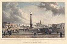
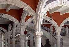
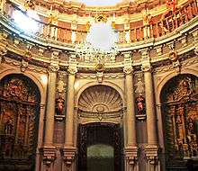
The old part of the city revolves around downtown and the four original neighborhoods from which the city expanded. The most notable building here is the Baroque Government Palace, dating from 1664 and constructed out of red volcanic stone, it is known for its hundred arches. The prominent Baroque Cathedral, begun in 1575, is the oldest building in the city. The tall column in the center of the main square dates from colonial times; it held a statue of a Spain's viceroy, which was toppled when the country gained independence; the current sculpture on its summit commemorates Mexican independence.

Neighborhoods and tradition
The city of Aguascalientes is made up of four traditional neighborhoods, all of which grew up around the central Plaza de la Patria: Guadalupe, San Marcos, El Encino and La Estacion.
The neighborhood of Guadalupe, a traditional producer of pottery, centers around its local temple. At the heart of Guadalupe, you'll recognize this religious sanctuary – the second most important in the city and dating back to the late 18th century – by its baroque façade. Look up and you won't miss the temple's enormous dome covered in traditional talavera tiles. Venture inside and you'll be surrounded by the temple's many flower and angel motifs – a true baroque paradise.
The next is San Marcos, founded in 1604 and once home to natives of Tlaxcala state who fled persecution. Today, the area hosts the traditional San Marcos Fair in springtime. There is San Marcos Gardens, a charming green spot where paths and trees are abundant. The gardens are traditionally frequented by poets, artists and lovers on lazy afternoons. Directly in front of the gardens, you'll see the baroque San Marcos Temple, its tiled dome glinting in the sun.
In El Encino or La Triana, head for the Encino gardens with their tile-decorated central fountain is full of tranquility. While in the area, the Jose Guadalupe Posada Museum – showcasing the work of an extraordinary cartoonist and engraver born in Aguascalientes – is well worth a visit. The museum houses two permanent exhibition rooms and another for temporary exhibitions. Last but not least, the neighborhood of La Estacion takes its name from the old railway station, inaugurated in 1911 and one of Aguascalientes' architectural and historical treasures.
Aguascalientes historic downtown is home to several outstanding museums including the Aguascalientes Museum (Museo de Aguascalientes), the city's art museum, housed in a Classical-style building designed by the beloved self-trained architect Refugio Reyes; the Guadalupe Posada Museum (Museo Guadalupe Posada), located in the historic nationhood of Triana, exhibits the life and work of José Guadalupe Posada; and the State History Museum, which is housed in an elegant Art Nouveau mansion typical of the Porfirian period with and ornate patio and dining room with vegetable motifs in a Mediterranean style, with a French Academism façade, and interior columns and an arcade of pink stone characteristic of Porfirian Eclecticism.
Other designs by Refugio Reyes include the Paris Hotel, the Francia Hotel, and his masterpiece, the superb Church of San Antonio, considered to be one of the most beautiful churches in Mexico. The Church of our Lady of Guadalupe possesses an extraordinarily exuberant Baroque facade designed by José de Alcibar, a renowned architect of the period considered to be one of the most famous artists in Mexico in the 1770s. The Camarin of the Immaculate in the church of San Diego is considered by historians to be the last Baroque building in the world; it links the Baroque and Neoclassical styles; it is the largest of the fewer than ten of these type of structures built in the whole continent.
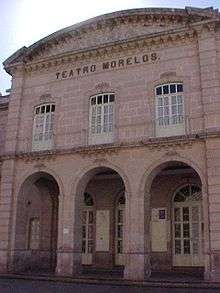
Aguascalientes is also home to some of the country's leading provincial theaters. Outstanding examples are the Morelos Theater, historically important for its role during the Mexican Revolution as a convention site; architecturally, the building is notable for its facade and interior, which houses a small museum. The Teatro Aguascalientes is the city's premier theatre and opera house and is equipped with the latest technology.
In addition, in the modern section of the city, the Museo Descubre astonishes as an interactive museum of science and technology aimed at providing a hands-on learning experience. It also features an IMAX screen. The Museum of Contemporary Art is the city's premier art museum.
The gothic structure of the Los Arquitos cultural center used to be one of the first bathhouses in the city, declared a historic monument in 1990. The Ojocaliente is also an original bathhouse still in use today, and fed with thermal springs. La Estacion Historic Area (The Old Train Station Complex) contains the Old Train Station and Railway Museum historic complex, which at some point in 1884 formed the largest rail hub and warehouses in all Latin America. The complex is adorned with dancing fountains, a railway plaza and original locomotives and monuments. It was in this complex that the first locomotive completely manufactured in Mexico was made. It symbolizes the progress of the city and its transformation from the rural to an emergent industrial economy. The rail factories supplied with railways and locomotives to whole of Mexico and Central America. The Train Station is also historic due to its unusual (for Mexico) English architectural style. The Alameda avenue, the railway hangars, the factory complexes, and its surrounding housing have been proposed to be placed in the list of UNESCO World Heritage Sites.
Notable residents
- José María Bocanegra, lawyer, interim President of Mexico in December 1829, minister in the national government 1833-44
- Manuel M. Ponce, musician
- José Guadalupe Posada, artist
- Saturnino Herrán, artist
- Enrique Jiménez, musician
- Sergio Vallín, Maná guitarist
- Jose Antonio Zapata Cabral, journalist
- Yadhira Carrillo, telenovela actress
- Ernesto Alonso, telenovela director/actor
- Jaime Humberto Hermosillo, film director
- José María Napoleón, singer/composer
- Luis Gerardo Méndez, Actor
Sports
The city is home to the soccer team Club Necaxa, which currently plays national second tier known as Liga de ascenso (formerly Primera A). The club left Mexico City and relocated to Aguascalientes following the 2003 opening of Estadio Victoria, which is now the club's home venue. Panteras de Aguascalientes is the city's entry in Mexico's National Professional Basketball League. The baseball team Rieleros de Aguascalientes, returned to the Mexican League in 2012. The team previously won the championship in 1978.
References
- ↑ Javier Rodríguez Lozano. "En estos días Aguascalientes llegará al millón de habitantes - La Jornada Aguascalientes (LJA.mx)". La Jornada Aguascalientes (LJA.mx). Retrieved 7 September 2014.
- ↑ "Bajío, el nuevo milagro mexicano - T21". T21. Retrieved 7 September 2014.
- 1 2 "Historia de la Ciudad de Aguascalientes". Ags.itesm.mx. Archived from the original on October 21, 2013. Retrieved 7 September 2014.
- ↑ "Aguascalientes, la ciudad más limpia de Latinoamérica :: El Informador". EL INFORMADOR. Retrieved 7 September 2014.
- ↑ "Línea Verde contará con servicios digitales - La Jornada Aguascalientes (LJA.mx)". La Jornada Aguascalientes (LJA.mx). Retrieved 7 September 2014.
- ↑ "Aguascalientes, traditional city in Mexico". Visitmexico.com. Retrieved 7 September 2014.
- 1 2 3 4 5 6 7
- 1 2 "Se ofertan mil empleos a jóvenes en Aguascalientes". Desdelared.com.mx. Retrieved 7 September 2014.
- ↑ "Aguascalientes recibió a 187 mil turistas este verano". Desdelared.com.mx. Retrieved 7 September 2014.
- ↑ Díaz Márquez, Ilse. "Fundación de Aguascalientes". Gobierno del Estado de Aguascalientes. Archived from the original on March 11, 2016. Retrieved February 23, 2016.
- ↑ "Barrio del Encino (Barrio de Triana)". Gobierno del Estado de Aguascalientes. Retrieved 23 February 2016.
- ↑ Dobrowolski, Jim W. (29 December 2015). "The Four Historical Neighborhoods of Aguascalientes". Retrieved 23 February 2016.
- ↑ "Barrios de Aguascalientes, México | VisitMexico". www.visitmexico.com. Retrieved 2016-02-24.
- ↑ "Barrio de la Estación". Gobierno del Estado de Aguascalientes. Retrieved 24 February 2016.
- ↑ NORMALES CLIMATOLÓGICAS 1951-2010 (in Spanish). National Meteorological Service of Mexico. Retrieved August 30, 2012.
- ↑ "Normales climatológicas para Aguascalientes, AGS" (in Spanish). Colegio de Postgraduados. Retrieved January 5, 2013.
- ↑ "Número de habitantes. Aguascalientes". cuentame.inegi.org.mx. Retrieved 2016-02-23.
- ↑ INEGI, CONAPO, SEDESOL (2000). Instituto Nacional de Estadística y Geografía (ed.): «Ciudades de México por IDH» (PDF).
- ↑ Ltd., NISSAN MOTOR Co.,. "NISSAN | NISSAN INAUGURATES ALL-NEW AGUASCALIENTES, MEXICO PLANT, BUILDING ON A REPUTATION FOR QUALITY AND EFFICIENCY". www.nissan-global.com. Retrieved 2016-02-23.
- ↑ "Home Archived October 3, 2016, at the Wayback Machine.." Escuela Japonesa de Aguascalientes. Retrieved on May 10, 2014. "Avenida del Lago 161,Jardines del Parque,Aguascalientes, AGS,C.P.20276,Mexico"
- ↑ "Visita a la Escuela Japonesa de Aguascalientes" (Archive). La Jornada Aguascalientes. Retrieved on October 1, 2013.
- ↑ "Se implementará en Aguascalientes el proyecto de Movilidad en Bicicleta del DF - La Jornada Aguascalientes (LJA.mx)". La Jornada Aguascalientes (LJA.mx). Retrieved 7 September 2014.
In popular culture
Aguascalientes was the hometown of Esperanza Ortega in the book Esperanza Rising.
External links
| Wikimedia Commons has media related to City of Aguascalientes. |
| Wikivoyage has a travel guide for Aguascalientes. |
- Municipal website
- News website including streaming media and radio news
- Grupo de Usuarios de Linux de Aguascalientes
- City Map and Commercial guide with street search and product/company search
- Fotos, Mensajes, y Mas de Aguascalientes
- Photographs of Aguascalientes in flickr.com
- Link to tables of population data from Census of 2005 INEGI: Instituto Nacional de Estadística, Geografía e Informática
Coordinates: 21°52′34″N 102°17′46″W / 21.876°N 102.296°W