Atlanta, Kansas
| Atlanta, Kansas | |
|---|---|
| City | |
 Location within Cowley County and Kansas | |
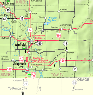 KDOT map of Cowley County (legend) | |
| Coordinates: 37°26′7″N 96°46′7″W / 37.43528°N 96.76861°WCoordinates: 37°26′7″N 96°46′7″W / 37.43528°N 96.76861°W | |
| Country | United States |
| State | Kansas |
| County | Cowley |
| Area[1] | |
| • Total | 0.50 sq mi (1.29 km2) |
| • Land | 0.50 sq mi (1.29 km2) |
| • Water | 0 sq mi (0 km2) |
| Elevation | 1,434 ft (437 m) |
| Population (2010)[2] | |
| • Total | 195 |
| • Estimate (2015)[3] | 193 |
| • Density | 390/sq mi (150/km2) |
| Time zone | Central (CST) (UTC-6) |
| • Summer (DST) | CDT (UTC-5) |
| ZIP code | 67008 |
| Area code | 620 |
| FIPS code | 20-03050 [4] |
| GNIS feature ID | 0470029 [5] |
Atlanta is a city in Cowley County, Kansas, United States. As of the 2010 census, the city population was 195.[6]
History
Atlanta was founded in 1885.[7] The first post office in Atlanta was established on August 14, 1885.[8]
Geography
Atlanta is located at 37°26′7″N 96°46′7″W / 37.43528°N 96.76861°W (37.435287, -96.768672).[9] According to the United States Census Bureau, the city has a total area of 0.50 square miles (1.29 km2), all of it land.[1]
Climate
The climate in this area is characterized by hot, humid summers and generally mild to cool winters. According to the Köppen Climate Classification system, Atlanta has a humid subtropical climate, abbreviated "Cfa" on climate maps.[10]
Demographics
| Historical population | |||
|---|---|---|---|
| Census | Pop. | %± | |
| 1910 | 330 | — | |
| 1920 | 379 | 14.8% | |
| 1930 | 348 | −8.2% | |
| 1940 | 286 | −17.8% | |
| 1950 | 309 | 8.0% | |
| 1960 | 267 | −13.6% | |
| 1970 | 216 | −19.1% | |
| 1980 | 256 | 18.5% | |
| 1990 | 232 | −9.4% | |
| 2000 | 255 | 9.9% | |
| 2010 | 195 | −23.5% | |
| Est. 2015 | 193 | [3] | −1.0% |
| U.S. Decennial Census | |||
2010 census
As of the census[2] of 2010, there were 195 people, 75 households, and 56 families residing in the city. The population density was 390.0 inhabitants per square mile (150.6/km2). There were 107 housing units at an average density of 214.0 per square mile (82.6/km2). The racial makeup of the city was 83.1% White, 4.1% Native American, 4.6% from other races, and 8.2% from two or more races. Hispanic or Latino of any race were 13.3% of the population.
There were 75 households of which 33.3% had children under the age of 18 living with them, 53.3% were married couples living together, 14.7% had a female householder with no husband present, 6.7% had a male householder with no wife present, and 25.3% were non-families. 20.0% of all households were made up of individuals and 6.6% had someone living alone who was 65 years of age or older. The average household size was 2.60 and the average family size was 3.04.
The median age in the city was 40.4 years. 27.7% of residents were under the age of 18; 7.1% were between the ages of 18 and 24; 22.5% were from 25 to 44; 23.1% were from 45 to 64; and 19.5% were 65 years of age or older. The gender makeup of the city was 51.8% male and 48.2% female.
2000 census
As of the census[4] of 2000, there were 255 people, 99 households, and 70 families residing in the city. The population density was 507.8 people per square mile (196.9/km²). There were 116 housing units at an average density of 231.0 per square mile (89.6/km²). The racial makeup of the city was 90.20% White, 5.49% Native American, and 4.31% from two or more races. Hispanic or Latino of any race were 0.39% of the population.
There were 99 households out of which 29.3% had children under the age of 18 living with them, 56.6% were married couples living together, 9.1% had a female householder with no husband present, and 28.3% were non-families. 28.3% of all households were made up of individuals and 14.1% had someone living alone who was 65 years of age or older. The average household size was 2.58 and the average family size was 3.07.
In the city the population was spread out with 29.4% under the age of 18, 5.9% from 18 to 24, 25.9% from 25 to 44, 24.7% from 45 to 64, and 14.1% who were 65 years of age or older. The median age was 36 years. For every 100 females there were 94.7 males. For every 100 females age 18 and over, there were 85.6 males.
The median income for a household in the city was $29,375, and the median income for a family was $36,250. Males had a median income of $31,250 versus $19,286 for females. The per capita income for the city was $12,727. About 13.4% of families and 15.5% of the population were below the poverty line, including 18.2% of those under the age of eighteen and 8.8% of those sixty five or over.
References
- 1 2 "US Gazetteer files 2010". United States Census Bureau. Archived from the original on 2012-01-24. Retrieved 2012-07-06.
- 1 2 "American FactFinder". United States Census Bureau. Retrieved 2012-07-06.
- 1 2 "Annual Estimates of the Resident Population for Incorporated Places: April 1, 2010 to July 1, 2015". Retrieved July 2, 2016.
- 1 2 "American FactFinder". United States Census Bureau. Archived from the original on 2013-09-11. Retrieved 2008-01-31.
- ↑ "US Board on Geographic Names". United States Geological Survey. 2007-10-25. Retrieved 2008-01-31.
- ↑ "2010 City Population and Housing Occupancy Status". U.S. Census Bureau. Archived from the original on July 26, 2011. Retrieved March 6, 2011.
- ↑ Kansas State Historical Society (1916). Biennial Report of the Board of Directors of the Kansas State Historical Society. Kansas State Printing Plant. p. 168.
- ↑ "Kansas Post Offices, 1828-1961 (archived)". Kansas Historical Society. Archived from the original on October 9, 2013. Retrieved 6 June 2014.
- ↑ "US Gazetteer files: 2010, 2000, and 1990". United States Census Bureau. 2011-02-12. Retrieved 2011-04-23.
- ↑ Climate Summary for Atlanta, Kansas
Further reading
- County
- History of Cowley County Kansas; D.A. Millington / E.P. Greer; Winfield Courier; 162 pages; 1901. (Download 16MB PDF eBook)
- Kansas
- History of the State of Kansas; William G. Cutler; A.T. Andreas Publisher; 1883. (Online HTML eBook)
- Kansas : A Cyclopedia of State History, Embracing Events, Institutions, Industries, Counties, Cities, Towns, Prominent Persons, Etc; 3 Volumes; Frank W. Blackmar; Standard Publishing Co; 944 / 955 / 824 pages; 1912. (Volume1 - Download 54MB PDF eBook), (Volume2 - Download 53MB PDF eBook), (Volume3 - Download 33MB PDF eBook)
External links
| Wikimedia Commons has media related to Atlanta, Kansas. |
- City
- Schools
- USD 462, local school district
- Maps
- Atlanta City Map, KDOT
Municipalities and communities of Cowley County, Kansas, United States | ||
|---|---|---|
| Cities |  | |
| Unincorporated communities | ||
| Townships | ||
| Footnotes | ‡This populated place also has portions in an adjacent county or counties | |