Parkerfield, Kansas
| Parkerfield, Kansas | |
|---|---|
| City | |
 Location within Cowley County and Kansas | |
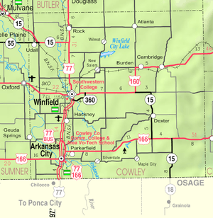 KDOT map of Cowley County (legend) | |
| Coordinates: 37°4′30″N 97°0′11″W / 37.07500°N 97.00306°WCoordinates: 37°4′30″N 97°0′11″W / 37.07500°N 97.00306°W | |
| Country | United States |
| State | Kansas |
| County | Cowley |
| Township | Creswell |
| Incorporated | March 16, 2004 |
| Area[1] | |
| • Total | 0.94 sq mi (2.43 km2) |
| • Land | 0.94 sq mi (2.43 km2) |
| • Water | 0 sq mi (0 km2) |
| Elevation[2] | 1,142 ft (348 m) |
| Population (2010)[3] | |
| • Total | 426 |
| • Estimate (2015)[4] | 415 |
| • Density | 450/sq mi (180/km2) |
| Time zone | Central (CST) (UTC-6) |
| • Summer (DST) | CDT (UTC-5) |
| ZIP code | 67005 (Arkansas City) |
| Area code | 620 |
| FIPS code | 20-54560 [2] |
| GNIS feature ID | 2061831 [2] |
| Website | City Website |
Parkerfield is a city situated in the southwest part of Cowley County, located in south-central Kansas, in the Central United States. As of the 2010 census, the city population was 426.[5]
History
Parkerfield was incorporated as a city of the third class on March 16, 2004, and elections for mayor and city council were held March 30.[6] The decision to incorporate the city grew out of a protest by area residents of neighboring Arkansas City's plan to annex the area. They believed the city codes to be too restrictive and the taxes too high. The residents hired an attorney to fight the annexation.[7] The petition for incorporation was filed with the Cowley County Clerk on January 20, 2004, and was approved by the Board of County Commissioners on March 9.[6]
Geography
Parkerfield is located at (37.085036,-96.998978),[8] near the east edge of Arkansas City. The land topography consists of about 564 acres (261 acres platted and 302 acres (1.22 km2) unplatted at the time of incorporation) with basically a flat terrain with no natural boundaries and a drainage pattern generally to the southeast for the southern half of the area and to the northwest for the northern half of the area.[6]
According to the United States Census Bureau, the city has a total area of 0.94 square miles (2.43 km2), all of it land.[1]
Law and government
Parkerfield is incorporated as a city of the third class and, as such, receives services from Creswell Township and Cowley County. Governmental services are provided through the acquisition of water from a rural water district, private sewage systems, fire protection from a rural fire district, law enforcement from the Cowley County Sheriff's Department, and road maintenance by the township and the county.[6] The city is run by an elected mayor and five-member city council, and an appointed city clerk and city treasurer—all unpaid positions.[7]
Demographics
| Historical population | |||
|---|---|---|---|
| Census | Pop. | %± | |
| 2010 | 426 | — | |
| Est. 2015 | 415 | [4] | −2.6% |
| U.S. Decennial Census | |||
The city was incorporated on March 16, 2004, thus its first census was the 2010 census.
2010 census
As of the census[3] of 2010, there were 426 people, 156 households, and 125 families residing in the city. The population density was 453.2 inhabitants per square mile (175.0/km2). There were 158 housing units at an average density of 168.1 per square mile (64.9/km2). The racial makeup of the city was 95.5% White, 0.2% African American, 1.2% Native American, 1.6% Asian, 0.7% from other races, and 0.7% from two or more races. Hispanic or Latino of any race were 1.9% of the population.
There were 156 households of which 32.7% had children under the age of 18 living with them, 71.8% were married couples living together, 3.8% had a female householder with no husband present, 4.5% had a male householder with no wife present, and 19.9% were non-families. 16.0% of all households were made up of individuals and 7.7% had someone living alone who was 65 years of age or older. The average household size was 2.73 and the average family size was 2.99.
The median age in the city was 47.1 years. 25.8% of residents were under the age of 18; 5.2% were between the ages of 18 and 24; 15% were from 25 to 44; 35.5% were from 45 to 64; and 18.5% were 65 years of age or older. The gender makeup of the city was 50.7% male and 49.3% female.
References
- 1 2 "US Gazetteer files 2010". United States Census Bureau. Archived from the original on January 24, 2012. Retrieved 2012-07-06.
- 1 2 3 "US Board on Geographic Names". United States Geological Survey. 2007-10-25. Retrieved 2008-01-31.
- 1 2 "American FactFinder". United States Census Bureau. Retrieved 2012-07-06.
- 1 2 "Annual Estimates of the Resident Population for Incorporated Places: April 1, 2010 to July 1, 2015". Retrieved July 2, 2016.
- ↑ "2010 City Population and Housing Occupancy Status". U.S. Census Bureau. Archived from the original on July 21, 2011. Retrieved March 6, 2011.
- 1 2 3 4 "Cowley County Commission Minutes 2004". March 9, 2004. Archived from the original on November 14, 2006. Retrieved 2007-12-28.
- 1 2 Farrar, Foss (April 15, 2005). "Parkerfield: One year later". The Ark City Traveler. Retrieved 2007-12-29.
- ↑ "US Gazetteer files: 2010, 2000, and 1990". United States Census Bureau. 2011-02-12. Retrieved 2011-04-23.
Further reading
- County
- History of Cowley County Kansas; D.A. Millington / E.P. Greer; Winfield Courier; 162 pages; 1901. (Download 16MB PDF eBook)
- Kansas
- History of the State of Kansas; William G. Cutler; A.T. Andreas Publisher; 1883. (Online HTML eBook)
- Kansas : A Cyclopedia of State History, Embracing Events, Institutions, Industries, Counties, Cities, Towns, Prominent Persons, Etc; 3 Volumes; Frank W. Blackmar; Standard Publishing Co; 944 / 955 / 824 pages; 1912. (Volume1 - Download 54MB PDF eBook), (Volume2 - Download 53MB PDF eBook), (Volume3 - Download 33MB PDF eBook)
External links
| Wikimedia Commons has media related to Parkerfield, Kansas. |
- City
- Schools
- USD 470, local school district
- Maps
- Parkerfield City Map, KDOT
Municipalities and communities of Cowley County, Kansas, United States | ||
|---|---|---|
| Cities |  | |
| Unincorporated communities | ||
| Townships | ||
| Footnotes | ‡This populated place also has portions in an adjacent county or counties | |