Aywaille
| Aywaille | ||
|---|---|---|
| Municipality | ||
|
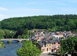
The Amblève in Aywaille | ||
| ||
 Aywaille Location in Belgium | ||
|
Location of Aywaille in Liège province  | ||
| Coordinates: 50°28′N 05°40′E / 50.467°N 5.667°ECoordinates: 50°28′N 05°40′E / 50.467°N 5.667°E | ||
| Country | Belgium | |
| Community | French Community | |
| Region | Wallonia | |
| Province | Liège | |
| Arrondissement | Liège | |
| Government | ||
| • Mayor | Philippe Dodrimont | |
| • Governing party/ies | EC | |
| Area | ||
| • Total | 79.97 km2 (30.88 sq mi) | |
| Population (1 January 2016)[1] | ||
| • Total | 12,257 | |
| • Density | 150/km2 (400/sq mi) | |
| Postal codes | 4920 | |
| Area codes | 04 | |
| Website | www.aywaille.be | |
Aywaille is a Belgian municipality located in the Walloon province of Liège. On January 1, 2012, Aywaille had a total population of 11,697. The total area is 80.04 km² which gives a population density of 146 inhabitants per km².[2] Its area consists of 45,7 % of wooded and wild country, 29,9 % of agricultural areas and 24,4 % of built-up areas.[3]
The inhabitants of Aywaille are called the "Aqualiens", from the Latin version of Aywaille "Aqualia loca", which means "area full of water" or "muddy land".[3]
The municipality includes not only the entity of Aywaille itself but also the entities of Ernonheid, Harzé, and Sougné-Remouchamps. They include many villages as Aywaille, Awan, Chambralles, Deigné, Ernonheid, Paradis, Houssonloge, Pouhon, Harzé, Havelange, Kin, Stoqueu, Martinrive, Nonceveux, Playe, Quarreux, Sedoz, Septroux, Sougné, Remouchamps, Ville-au-Bois.[3]
Tourism[3]
The municipality of Aywaille combines the interest for a business center (170 stores) and a weekly market with a very attractive touristic resort based on some charming villages.
It offers a large range of possibilities to get in touch with the nature thanks to its various walking routes, horse riding and mountain bikes circuits.
The Cave of Remouchamps (conservation area) has a marvelous underground navigation - the longest in Europe. This cave called "Wonder in the wonders" installed since 1829, attracts yearly thousands of visitors. You can cover a distance of about 2800 m. It mainly consists of the superposition of two galleries. On the upper plan, it's a spacious passage you go through from one end to the other. The lower gallery contains the Rubicon bed, underground meandering river on which the visitors are brought back on boats to their starting point. Near Remouchamps, the "Vallon des Chantoirs", characterized by absorption points in a calcareous underground, gets the water together in a huge collector that ends up in the cave of Remouchamps to form the Rubicon.
At the gateway of the Ardennes, the castle of Harzé, a provincial property, is a high building in grey stone with openings of one or two mullions with its flight steps and its balcony. In the main courtyard, you can appreciate the mosan Renaissance style with its semicircular arches on Tuscan pillars and its three mullions windows. In the castle, you can visit the Watermill and the Bakery museums.
Deigné proposes to us to stroll in its peaceful alleys. Its stone houses (in sandstone and limestone), most of them from the 18th century have an exceptional architectural charm.
Not far from there, the Safari park, the "Monde Sauvage" ("Wild World"), attracts old and young. There you can in safety see and come close, by car or by little train, to all kinds of animals in liberty.
Among the most capricious streams meandering in our valleys and flowing into the Amblève, the listed Ninglinspo valley, combines wild beauty with a great variety of sites with enchanting names (Bain du Cerf, Bain de Diane, Bain des Naïades, Bouillon de la Chaudière, etc.).
The Dieupart Church belongs to Aywaille village that is known as a "Notre Dame" Basilica.
Sougné is a very old village linked to Remouchamps, with the well-known steep hill of the Redoute road, the ruins of the Neufchateau-sur-Emblève castle, Saint-Anne Chapel.
Awan has its castle and its Christmas illuminations.
See also
References
- ↑ Population per municipality as of 1 January 2016 (XLS; 397 KB)
- ↑ "Commune d'Aywaille: coordonnées, bourgmestre, coalition, population et superficie". www.uvcw.be. Retrieved 2015-11-03.
- 1 2 3 4 "Commune d'Aywaille ...". www.aywaille.be. Retrieved 2015-11-03.
External links
-
 Media related to Aywaille at Wikimedia Commons
 |
Comblain-au-Pont | Sprimont |  | |
| Ferrières | |
Theux | ||
| ||||
| | ||||
| Ferrières | Stoumont |

