Bohuslän
| Bohuslän | ||
|---|---|---|
| ||
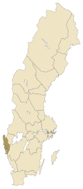 | ||
| Country | Sweden | |
| Land | Götaland | |
| County | Västra Götaland County | |
| Area | ||
| • Total | 4,400 km2 (1,700 sq mi) | |
| Population (2009)[1] | ||
| • Total | 287,224 | |
| • Density | 65/km2 (170/sq mi) | |
| Ethnicity | ||
| • Language | Swedish | |
| • Dialect | Götamål | |
| Culture | ||
| • Flower | European honeysuckle | |
| • Animal | Harbour seal | |
| • Bird | Eurasian oystercatcher | |
| • Fish | Mackerel | |
| Time zone | CET (UTC+1) | |
| • Summer (DST) | CEST (UTC+2) | |

Bohuslän (Swedish pronunciation: [ˈbuːhʉːsˌlɛːn]) is a Swedish province in Götaland, on the northernmost part of the country's west coast. It is bordered by Dalsland to the northeast, Västergötland to the southeast, the Skagerrak arm of the North Sea to the west, and the county of Østfold, in Norway, to the north.
Bohuslän is named after the Norwegian medieval castle of Båhus. Under the name Båhuslen, it was a Norwegian county from the unification in the 870s until the Treaty of Roskilde in 1658, when the kingdom of Denmark-Norway lost this area as well as Skåneland to Sweden.
Administration
The provinces of Sweden serve no administrative function. Instead, that function is served by the counties of Sweden. For centuries, the administrative county for Bohuslän was the Gothenburg and Bohus County, and as its name implies it consisted of the entire Bohuslän province together with the city Gothenburg. In 1998, some Swedish counties were merged to reduce administration costs, and Gothenburg and Bohus County were therefore merged into the new, much larger Västra Götaland County.
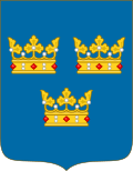
Heraldry
Bohuslän was granted its arms at the time of the funeral for Charles X Gustav of Sweden in 1660. It was identical to the arms of the Town of Kungälv. In 1962 the higher claim of the town was established and a variation for the arms of the county was introduced. The coat of arms is surmounted by a ducal coronet. Blazon: "Argent, a Castle embattled Gules with one embattled Tower of the same and two doors Or hinged Sable between a Sword point upwards and Lion rampant holding the Tower both Azure langued and armed Or."
Geography

The geography is distinguished by the rocky coast, bordering an archipelago: there are about 3,000 islands and 5,000 islets (skerries). These make up the northern part of the Gothenburg archipelago, Sweden's second largest after Stockholm archipelago. In old days, the seascape was renowned for its many reefs and sunken rocks which caused many shipwrecks. Two of the largest islands, Orust and Tjörn, constitute their own municipalities. Both islands have a distinctive culture and history. However, the rocky terrain cannot be said to be mountainous: the highest point is Björnepiken at 224 meters.
Sweden's only threshold fjord, Gullmarn or Gullmarsfjorden, is located near Lysekil. It is 25 kilometres (16 mi) long and 1 to 3 kilometres (0.62 to 1.86 mi) wide with a maximum depth of 118.5 metres (389 ft). The fjord is home to unique marine life.
Bohuslän's coastline was ranked 7th among the world's last great wilderness areas by CNN Travel.[2]
Unlike other parts of Sweden, there are relatively few lakes or streams in Bohuslän: out of a total land area of 4,500 square kilometres (1,700 sq mi) only 177 square kilometres (68 sq mi) is freshwater. Although lakes are common, they tend to be small in size. The largest lakes are the northern and southern Bullaren lakes, with a combined area of about 40 square kilometres (15 sq mi).
Population
As of 31 December 2009, the number of inhabitants was 287,223,[1] giving a population density of 65.3 inhabitants/square kilometer.
Islands of Bohuslän
|
Larger settlements in Bohuslän
Bohuslän's chartered cities are:
- Kungälv (approximately 1100)
- Lysekil (1903)
- Marstrand (approximately 1200)
- Strömstad (1672)
- Uddevalla (1498)
Their central areas are now non-administrative urban areas.
In addition there are several other notable settlements:
|
History

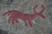
During the 2nd millennium BC, the Nordic Bronze Age began (c. 1700-500 BC), including rock art such as the examples found throughout Bohuslän. During the Migration Period (300 to 700 AD) and the Viking Age (700-1000 AD), the area was part of Viken, and was actually known as two entities: Rånrike in the north and Elfsyssel in the south. It has been claimed that King Harald Fairhair made it part of the unified Norway in about 872, but contemporary sources give rise to doubt that Harald actually ever held the Viken area properly. The earliest proof of Båhus lands being in Norway's hands is from the 11th century.
As long as Norway was a kingdom of its own, the province prospered, and Båhus castle was one of the key fortresses of the kingdom. When Norway was united with Denmark, the province began its decline in wealth; the area was frequently attacked by Swedish forces as part of the larger border skirmishes. The Norwegian fortress, Båhus, was built to protect this territory. Being a border zone towards the Swedish kingdom, and to a lesser extent against Danish lands in Halland, the Båhus region was disproportionately populated by soldier families.
Båhuslen belonged to Denmark-Norway until it was ceded to Sweden in the Treaty of Roskilde in 1658. This fact explains why the treaty was signed in Denmark. The fortress of Carlsten was built in Marstrand during the 17th century. For a period Marstrand was also a free port (porto Franco), with a free religious practice and, as such, home to the only synagogue in Sweden at the time.
The commercial fishing of herring increased in the 18th century, and the province flourished during a major herring period around 1747–1809. Many small fishing communities grew up around the coast.
Before the large scale fishing of herring started, Bohuslän had a considerable forest cover. Timber was once the largest export product and main source of income in Bohuslän. But with the increased importance of fishing, more wood was needed as construction material for houses and boats, and as fuel for herring oil boilers (trankokerier). Deforestation during the 19th century gave rise to today's rugged, rocky landscape.
Culture

In Bohuslän a variety of the Götaland dialect of Swedish is spoken. The province was a part of Norway until 1658 as mentioned above. Still today traces of Norwegian remain in the dialect. "Bohuslän", literally means the "Fief of Bohus", referring to Bohus Fortress and län.
The Nordic Bronze Age (c. 1700-500 BC) produced rock art showing scenes from the daily life and religious rituals, such as the examples found in Bohuslän. The rock art at Tanum, possibly made earlier, c. 2,500 to 3,000 years ago, have been entered as a site in the UNESCO World heritage program. Rock carvings can be found scattered throughout Bohuslän. The carvings portray the life of an agricultural society with images of daily life, with human figures, religious rituals, ships, circular objects, soles, animals, and fertility figures (e.g. phalluses); and the creation of shallow bowls.
Hundreds
Hundreds of Sweden were sub-divisions of the Swedish provinces until the early 20th century. Bohuslän's hundreds were:
Sports
Despite the non-administrative status of Bohuslän some historical functions remain with football being administered by Bohusläns Fotbollförbund.
Notable people from Bohuslän
People from Bohuslän are known as bohusläningar.
- Percy Barnevik, Uddevalla - businessman
- Emilie Flygare-Carlén, Strömstad - author
- Karl-Axel Gadd, Sotenäs - artist
- Emma Jacobsson, Göteburg - founder of Bohus Stickning.
- Per Jacobsson - managing director of the International Monetary Fund
- Charles Magnus Lindgren, Dragsmark - Swedish-American shipping executive
- Ture Malmgren, Uddevalla - journalist and politician
- Karl Nordström, Tjörn - artist
- Karin Parrow, Vinga - artist
- Ernst Skarstedt, Kungälv - Swedish-American author, journalist and editor
- Gustaf B. Thordén, Uddevalla - shipping
See also
- History of Sweden
- Prehistoric Sweden (9,000 BC– 800 CE: Stone and Bronze Ages)
- Nordic Stone Age
- Nordic Bronze Age
- History of Sweden (CE 800–1521) (Viking and Middle Ages)
References
- 1 2 Statistics Sweden
- ↑ Reddy, Jini (2013-03-06). "10 of the world's last great wilderness areas". CNN. Retrieved 2013-05-04.
- article Bohuslän from Nordisk familjebok (1905). In Swedish.
External links
- Bohuslän - Official tourist site
- Destination northern Bohuslän
- Destination south Bohuslän
- Language
- The religious background of Bohuslän rock art (PDF)
| Wikimedia Commons has media related to Bohuslän. |
Coordinates: 58°14′53″N 11°53′13″E / 58.248°N 11.887°E