Balagtas, Bulacan
| Balagtas | ||
|---|---|---|
| Municipality | ||
|
Municipal Hall of Balagtas | ||
| ||
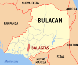 Map of Bulacan showing the location of Balagtas | ||
.svg.png) Balagtas Location within the Philippines | ||
| Coordinates: 14°48′52″N 120°54′30″E / 14.81447°N 120.90847°ECoordinates: 14°48′52″N 120°54′30″E / 14.81447°N 120.90847°E | ||
| Country | Philippines | |
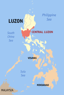
| Region | Central Luzon (Region III) | |
| Province | Bulacan | |
| District | 2nd District | |
| Founded | 1596 | |
| Barangays | 9 | |
| Government[1] | ||
| • Mayor | Eladio Gonzales, Jr. | |
| • Vice Mayor | Alberto Carating II | |
| Area[2] | ||
| • Total | 28.66 km2 (11.07 sq mi) | |
| Population (2015 census)[3] | ||
| • Total | 73,929 | |
| • Density | 2,600/km2 (6,700/sq mi) | |
| • Poverty rate |
| |
| Time zone | PST (UTC+8) | |
| ZIP code | 3016 | |
| IDD : area code | +63 (0)44 | |
| Income class | 1st | |
| Electricity | Manila Electric Company | |
| • Consumption | 49.61 million kWh (2003) | |


Balagtas is a first class urban municipality in the province of Bulacan, Philippines. According to the 2015 census, it has a population of 73,929 people.[3]
With the continuous expansion of Metro Manila, the municipality is now part of Manila's built up area which reaches San Ildefonso in its northernmost part.
Formerly known as Bigaa, it was renamed in honor of Filipino poet Francisco Balagtas. The MacArthur Highway bisects the municipality of Balagtas as this national road cuts northward to the Ilocos region. At the southern approach of the town from Manila is a modern, first class concrete bridge that crosses the Balagtas River. The river, navigable by banca and motor boats, empties into Manila bay after snaking through the town of Bulacan to the West which provides Balagtas' townsfolk with fish, shrimp, and other fresh water food.
At the foot of the bridge, along the highway towards the North, is the town hall. In front of the town hall is spacious park where the monument of it hero, Francisco Balagtas is located. The town hall is surrounded by Spanish colonial type houses. Two hundred meters from the municipal hall is the barrio of Panginay, the birthplace of Francisco "Balagtas" Baltazar, for whom also "Balagtasan", a form of debate in versified Tagalog, was named. In reverence to the hero's deeds, the official name of Bigaa was changed to Balagtas through the legislative act sponsored by the late Congressman, Teodulo Natividad.
In 1946 the Historical Society of the Philippines placed a marker at the birthplace of Balagtas, which reads: "Here in Barrio Panginay, Bigaa, Bulacan, Francisco Baltazar (Balagtas) was born on April 2, 1788. Son of Juan Baltazar and Juana de la Cruz, he is the father of Tagalog language and the author of the deathless "Florante at Laura." He died in Udyong, Bataan on February 20, 1862."
History
Originally known as Caruya/Caluya as per as the history records regarding the early years of the establishment of Bulacan Province, Caruya was one of the Encomiendas of the vast region La Pampanga falls under the Alcalde Mayor of Bulacan. Encomienda de Caruya was Encomienda of the King of Spain which appeared in Miguel de Loarca's Relacion delas Isla Filipinas in 1582 and the Report of Governor- General Luis Perez de Dasmariñas of June 21, 1591 document. The propagation of catholic instructions in Caruya initially belongs to Bulakan Convent and it was directly administered by Alcalde Mayor of Bulacan but it was transferred to Malolos Convent at uncertain date. Bigaa is one of the ancient towns of the Province together with Calumpit 1571 (became Town in 1575) Bulakan 1575 (became Town in 1578) Meycauayan 1578, Malolos 1571 (became Town in 1580) and Binto 1581 (a former visita of Malolos became Town renamed as Binto y Quingua 1602) later known as Plaridel. The Catalogo of 1591 indicates the existence of Guiguinto y Caruyan with 4,800 souls and it was administered by a religious from Bulacan Convent. In 1608 Historia dela Provincia Agustiana mentioned Caruyan as pueblo and convent. The Catalogo of 1612 says that Caruyan had 2 sacerdos, 800 Tributos, 2,400 Almas. (Historia de La Provincia Agustiana del Santisimo Nombre de Jesus de Filipinas Vol.1 of Isacio Rodriguez OSA)
On other data, the Center for Bulacan Studies in their "La Primera Provincia" published in 2010 p. 138 mentioned that Bigaa came from Malolos as its matrix with a date independency date of 1621. It could be assumed that Bigaa was later transferred to Malolos Convent in uncertain date but La Primera did not mention that Bigaa originally came from Bulakan town but instead in Malolos.
Long time before the construction of the church at Poblacion,the original location of the town center where the hermitage and the base of Spanish instruction in Bigaa was at Barrio Dalig where Sitio Caruyan was located.
It is very unclear when Caruya was formally organized into administrative town with its own Gobernadorcillo. It was renamed to Bigaa sometime in 1700s. Nigaa suggest a kind of plant which is Taro o Gabi.
During the Philippine revolution the "insurrectos" and the "Guardia civiles". Many people died, further decimating the town, which has suffered from a cholera epidemic and nearly wiped out the population 20 years before. When the Americans established civil government in 1903, Bigaa and Bocaue was integrated each other and in 1911 it was separated again.and on the same year,1911 the former Hacienda de Pandi, which included in the geographical jurisdiction of Town of Bigaa. In 1946, during the tenure of Bigaa Mayor Manuel Santos, Pandi was detached from Bigaa shortly after the Philippines gained political freedom from the United States and Pandi was established as a Municipal entity by virtue of a legislative fiat.
Barangays
Balagtas is politically subdivided into 9 barangays, all of which are urban:[2]
- Borol 1st
- Borol 2nd
- Dalig
- Longos
- Panginay
- Pulong Gubat
- San Juan
- Santol
- Wawa
Demographics
| Population census of Balagtas | ||
|---|---|---|
| Year | Pop. | ±% p.a. |
| 1990 | 42,658 | — |
| 1995 | 49,210 | +2.71% |
| 2000 | 56,945 | +3.18% |
| 2007 | 62,684 | +1.33% |
| 2010 | 65,440 | +1.58% |
| 2015 | 73,929 | +2.35% |
| Source: Philippine Statistics Authority[3][4] | ||
In the 2015 census, the population of Balagtas, Bulacan, was 73,929 people,[3] with a density of 2,600 inhabitants per square kilometre or 6,700 inhabitants per square mile.
List of Cultural Properties in Balagtas, Bulacan
| Cultural Property wmph identifier |
Site name | Description | Province | City/Municipality | Address/Location | Coordinates | Image |
|---|---|---|---|---|---|---|---|
| Constantino House | Ancestral House | Bulacan | Balagtas | MacArthur Highway | 14°49′01″N 120°54′28″E / 14.817059°N 120.907752°E | 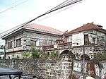 | |
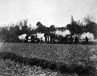
| Bigaa Railway Station | Train station | Bulacan | Balagtas | 14°49′31″N 120°54′21″E / 14.825216°N 120.905967°E | 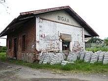 | ||
| Saint Lawrence, Deacon and Martyr Parish Church | Stone church | Bulacan | Balagtas | MacArthur Higway | 14°49′05″N 120°54′29″E / 14.818177°N 120.908111°ESaint Lawrence, Deacon and Martyr Parish Church) |  |
-

War memorial at the Municipal Hall
-

St. Lawrence Deacon & Martyr Parish Church (Barangay Longos)
-
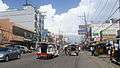
Downtown, busy commercial center
-
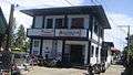
PNP Station
Economy
- Major Industries
- Ceramics/Pottery
- Furniture
- Garments
- Gifts/Houseware/Decors
- Metalcraft
- Major Products
- Furniture/Agricultural Products
- Balot and Penoy Industry
- Recruitment Agency
- Fruit Dealership
- Tilapia
- Tricycle Parts
- Future Developments
- Construction of North Food Exchange (under construction)
- Opening of Balagtas Tollgate
- Construction of new Balagtas to Baliwag road connection
Government
Municipal Officials:
- Mayor: Eladio "Kap JR." Gonzales
- Vice Mayor: Alberto "Bobby" Carating Jr.
- Councilors:
- Mikee Jane Payuran
- Analyn Jose
- Fernando K. Galvez
- Jay-R Aragon
- Andy De Guzman
- Dante Marcelo
- Jayree Galvez
- Jepok Ventura
Schools
Tertiary:
- College of St. Lawrence (formerly St.Lawrence Academy), Borol Ist, Balagtas
- Garden Angels Integrated School, Borol Ist, Balagtas
- STI College Balagtas, Campus, Borol Ist,Balagtas
- Colegio de Roma, San Juan, Balagtas
- Our Lady of Manaoag Montessori College, (OLMA) San Juan, Balagtas
- A-Z Country Day School
- Bulacan Merchant Marine Academy
Secondary:
- La Consolacion School, Longos, Balagtas
- Balagtas Agricultural School, Pulonggubat, Balagtas (main)
- Balagtas Agricultural School, Borol Ist, Balagtas (annex)
- Children's Mindware School, Borol 2nd, Balagtas
References
- ↑ "Official City/Municipal 2013 Election Results". Intramuros, Manila, Philippines: Commission on Elections (COMELEC). 11 September 2013. Retrieved 10 October 2013.
- 1 2 "Province: BULACAN". PSGC Interactive. Makati City, Philippines: National Statistical Coordination Board. Retrieved 10 October 2013.
- 1 2 3 4 "Region III (CENTRAL LUZON)". Census of Population (2015): Total Population by Province, City, Municipality and Barangay (Report). PSA. Retrieved 20 June 2016.
- ↑ "Region III (CENTRAL LUZON)". Census of Population and Housing (2010): Total Population by Province, City, Municipality and Barangay (Report). NSO. Retrieved 29 June 2016.
External links
| Wikimedia Commons has media related to Balagtas, Bulacan. |
See also
 |
Plaridel | Pandi | | |
| Guiguinto | |
Santa Maria Bocaue | ||
| ||||
| | ||||
| Bulakan |