Bald Eagle State Park
| Bald Eagle State Park | |
| Pennsylvania State Park | |
 Eagle nesting near Foster Joseph Sayers Dam | |
| Named for: Bald Eagle Creek | |
| Country | United States |
|---|---|
| State | Pennsylvania |
| County | Centre |
| Township | Howard, Liberty, Marion |
| Elevation | 958 ft (292.0 m) [1] |
| Coordinates | 41°02′30″N 77°36′12″W / 41.04167°N 77.60333°WCoordinates: 41°02′30″N 77°36′12″W / 41.04167°N 77.60333°W |
| Area | 5,900 acres (2,388 ha) |
| - water | 1,730 acres (700 ha) |
| Founded | July 4, 1971 |
| Management | Pennsylvania Department of Conservation and Natural Resources |
| IUCN category | II - National Park |
 Location of Bald Eagle State Park in Pennsylvania
| |
| Website: Bald Eagle State Park | |
Bald Eagle State Park is a 5,900-acre (2,388 ha) Pennsylvania state park in Howard, Liberty, and Marion townships in Centre County, Pennsylvania in the United States. The park includes the Foster Joseph Sayers Reservoir, formed by damming Bald Eagle Creek and other smaller streams and covering 1,730 acres (700 ha). Bald Eagle State Park is at the meeting point of two distinct geologic features. The Allegheny Plateau is to the north and the Ridge and Valley area of Pennsylvania is to the south. The park is in the Bald Eagle Valley off Pennsylvania Route 150 in Howard, between Milesburg and Lock Haven.
History
Lenape
The park is named for the Lenape chief, Woapalanne, meaning bald eagle. Chief Woapalanne lived in the area for a brief period of time during the mid-18th century in a village that was on Bald Eagle Creek Path, part of the much more extensive Great Indian Warpath that stretched from New York into the Carolinas. This path was used by the Iroquois to conduct raids on the Cherokee in North Carolina, South Carolina, Tennessee, and Georgia. Pennsylvania Route 150 follows this path in some areas near Bald Eagle State Park.[2]
Iron and lumber

Bald Eagle Creek is one of the few navigable tributaries of the West Branch Susquehanna River in Centre County. This made it a vital part of the transportation network in Centre County's early days. The Bald Eagle and Spring Creek Navigation canal was built from the Pennsylvania Canal at Lock Haven up Bald Eagle Creek and Spring Creek into Bellefonte in 1848. This canal was damaged by flooding in 1867[3] and went out of service. It was replaced by the Bald Eagle Valley Railroad, which completed its line along the valley in 1865.[2]
The availability of transportation and vast natural resources drew the iron industry and later the lumber industry to Bald Eagle Valley. The Eagle Ironworks was built in 1810 by Roland Curtin, an immigrant from Ireland. The ironworks produced iron along Bald Eagle Creek until it was closed in 1922. At first charcoal was used to fire the furnaces. This charcoal was produced locally by colliers who harvested timber from the mountainsides and slowly burned the logs to produce charcoal. Later the furnaces were adapted to use coal, another of Pennsylvania's plentiful natural resources.[2][4]
The demand for lumber products reached the Bald Eagle area in the mid-to-late 19th century. Vast stands of old-growth forest were harvested and sent down the West Branch Susquehanna River to the sawmills at Williamsport. The once abundant stands of pine, oak, hickory, chestnut and hemlock were stripped from the hills and valleys. The land in the valley was converted to farmland and is still farmed today. The forests on Bald Eagle Mountain have since regrown forming an extensive second growth forest.[2]
Foster Joseph Sayers Reservoir
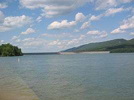

Foster Joseph Sayers Reservoir is a 1,730-acre (700 ha) reservoir that was built in 1971 by the U.S. Army Corps of Engineers as part of a flood control project on the Susquehanna River basin. The lake was created by damming Bald Eagle Creek. It stretches upstream for 8 miles (12.87 km) and has 23 miles (37.01 km) of shoreline. The park is at an elevation of 958 feet (292 m).[1]
War hero
The lake is named for Foster Joseph Sayers a World War II hero. Sayers grew up in Marsh Creek. He received the Medal of Honor for acts of bravery on November 12, 1944 near Thionville, France. His Medal of Honor citation reads as follows:
CITATION: Rank and organization: Private First Class, U.S. Army, Company L, 357th Infantry, 90th Infantry Division. Place and date: Near Thionville, France, 12 November 1944. Entered service at: Howard, Pa. Birth: Marsh Creek, Pa. G.O. No.: 89, 19 October 1945. Citation: He displayed conspicuous gallantry above and beyond the call of duty in combat on 12 November 1944, near Thionville, France. During an attack on strong hostile forces entrenched on a hill he fearlessly ran up the steep approach toward his objective and set up his machinegun 20 yards from the enemy. Realizing it would be necessary to attract full attention of the dug-in Germans while his company crossed an open area and flanked the enemy, he picked up his gun, charged through withering machinegun and rifle fire to the very edge of the emplacement, and there killed 12 German soldiers with devastating close-range fire. He took up a position behind a log and engaged the hostile infantry from the flank in an heroic attempt to distract their attention while his comrades attained their objective at the crest of the hill. He was killed by the very heavy concentration of return fire; but his fearless assault enabled his company to sweep the hill with minimum of casualties, killing or capturing every enemy soldier on it. Pfc. Sayers' indomitable fighting spirit, aggressiveness, and supreme devotion to duty live on as an example of the highest traditions of the military service.[5]
Boating
Unlimited horsepower motorboats are permitted on Foster Joseph Sayers Reservoir. Boats equipped with inboard engines with over the transom or straight-stack type exhausts are not permitted. All boats must have current registration with any state. Boaters must adhere to the speed-limit of 45 mph (72 km/h) and follow the counterclockwise pattern when navigating the lake. The marina has 369 docking slips that are available to rent seasonally or daily. Inland Marine and Power Sports operates the marina and provides various services to the public.[2]
- a limited grocery store
- towing service
- mechanic service for boats, motors and trailers
- boat and water ski rental
- gas sales, boat sales, and sales of boating equipment and accessories
There are six boat launches at Bald Eagle State Park. All are open 24 hours with parking and restroom facilities.
Fishing
Foster Joseph Sayers Reservoir is a warm water fishery. Fishing is permitted from the shore, on boats and from an ADA accessible pier located at the main boat launch in the central park area. The common game fish are largemouth and smallmouth bass, crappie, yellow perch, channel catfish, and tiger muskellunge.[2]
Swimming
Swimming is permitted on a beach stretching 1,200 feet (366 m) along the lake. The beach is open Memorial Day weekend until Labor Day weekend. The beach area includes a playground, snack bar, baby changing rooms, restrooms, and parking.[2]
Other recreation
Picnics
There are four picnic area at Bald Eagle State Park.
- Schencks Grove Picnic Area is on a point near the beach and marina. It has two pavilions with tables and several other picnic tables. This area also features two restrooms, two play fields, four horseshoe pits and four outdoor volleyball courts.[2]
- Beach Picnic Area is near the beach. It has four pavilions, two volleyball courts and some horseshoe pits.[2]
- Skyline Picnic Area is northeast of Schencks Picnic Area. It has a pavilion and shaded picnic tables, four restrooms, a volleyball court and horseshoe pit.[2]
- Summer/Winter Launch Picnic Area has a pavilion, a fishing pier, restroom, volleyball court and horseshoe pit.[2]
Hunting
Hunting is permitted on about 4,910 acres (1,990 ha) of Bald Eagle State Park. The most common game species are squirrels, turkey, rabbits, pheasant and white-tailed deer. The hunting of groundhogs is prohibited. Hunters are expected to follow the rules and regulations of the Pennsylvania Game Commission.[2]
Trails

Bald Eagle State Park has 11 miles (18 km) of trails that are open for hiking and cross-country skiing. Some of the trails pass through areas that are open to hunting and hikers and skiers are asked to wear blaze orange when using the trails during the hunting seasons. All trails are open year round at 8:00 a.m. and are closed at sunset.[6]
- Butterfly Trail - (1.5 miles (2.4 km)) is an easy loop trail marked with red blazes. It is a mowed grass trail and was created for the conservation of butterflies. The trail begins and ends near the beach. It loops around a pond and passes through a mix of grasses, shrubs, wildflowers, and young trees. This mixture of plant life creates a habitat for butterflies.[6]
- Hunter Run West Trail - (2 miles (3.2 km)) is a moderate trail marked with orange blazes. It begins near the campground at the Route 150 underpass. It is a mowed path that passes through a mix of forest and field habitats. Old stone fencerows can be seen near the trail. These fencerows are remnants of the farms that were once on the lands of Bald Eagle State Park.[6]
- Hunter Run East Trail - (2 miles (3.2 km)) also begins near the campground and is a moderate trail marked with yellow blazes. The trail is on the northwest border of the park. It passes through a mix of forest and shrub areas. The shrubs are habitats for chickadees, gray catbirds and towhees.[6]
- Lakeside Trail - (5.4 miles (8.7 km)) is a moderate hiking trail marked with blue blazes. The trail is very rocky and runs along the base of Bald Eagle Mountain. It passes by the lake amongst a mature hardwood forest of oak, maple and hickory trees. The trail also passes by signs of the charcoal industry that once thrived in the area to supply charcoal for the iron furnaces owned by Roland Curtin.[6]
- Skyline Drive Trail - (2 miles (3.2 km)) is an easy trail marked with white blazes. It connects with Butterfly Trail and passes through fields that are in various stages of ecological succession, gradually changing from the fields cleared by farmers back into forest.[6]
Camping
Russel P. Letterman campground is a modern campground with 97 campsites, three cottages, two yurts, hot showers, an amphitheater, a sanitary dump station and two volleyball courts. There is a paved parking area at each campsite as well as a picnic table and fire ring. All campsites have an electrical hook-up. The primitive camping area 35 walk-in sites and 35 sites for small campers. Outhouses are available as well as sinks with running water.[2]
Nearby state parks
The following state parks are within 30 miles (48 km) of Bald Eagle State Park:[7][8][9]
|
|

See also
 Pennsylvania portal
References
- 1 2 "Bald Eagle State Park". Geographic Names Information System. United States Geological Survey. August 30, 1990. Retrieved April 2, 2008.
- 1 2 3 4 5 6 7 8 9 10 11 12 13 "Bald Eagle State Park". Pennsylvania Department of Conservation and Natural Resources. Retrieved December 19, 2006.
- ↑ "Bald Eagle and Spring Creek Navigation Company". Big Spring Web Design. Retrieved January 30, 2007.
- ↑ Gerald G. Eggert. "Curtin's Ironworks". Pennsylvania State University. Retrieved December 19, 2006.
- ↑
- "Foster Joseph Sayers - War Hero". Americans.net. Archived from the original on October 22, 2006. Retrieved December 19, 2006.
- 1 2 3 4 5 6 "Bald Eagle State Park Trails". Pennsylvania Department of Conservation and Natural Resources. Archived from the original on 8 December 2006. Retrieved December 19, 2006.
- ↑ "Find a Park by Region (interactive map)". Pennsylvania Department of Conservation and Natural Resources. Retrieved November 17, 2011.
- ↑ 2007 General Highway Map Centre County Pennsylvania (PDF) (Map). 1:65,000. Pennsylvania Department of Transportation, Bureau of Planning and Research, Geographic Information Division. Retrieved July 27, 2007. Note: shows Bald Eagle State Park
- ↑ Michels, Chris (1997). "Latitude/Longitude Distance Calculation". Northern Arizona University. Archived from the original on 11 April 2008. Retrieved April 15, 2008.
External links
| Wikimedia Commons has media related to Bald Eagle State Park. |
- "Bald Eagle State Park official map" (PDF). (1153 KB)