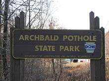
Archbald Pothole State Park
| Archbald Pothole State Park | |
| Pennsylvania State Park | |
 The pothole | |
| Named for: Archbald Pothole | |
| Country | United States |
|---|---|
| State | Pennsylvania |
| County | Lackawanna |
| Borough | Archbald |
| Elevation | 1,211 ft (369.1 m) [1] |
| Coordinates | 41°31′24″N 75°33′59″W / 41.52333°N 75.56639°WCoordinates: 41°31′24″N 75°33′59″W / 41.52333°N 75.56639°W |
| Area | 149.16 acres (60 ha) |
| Founded | 1964 |
| Management | Pennsylvania Department of Conservation and Natural Resources |
| IUCN category | III - Natural Monument |
 Location of Archbald Pothole State Park in Pennsylvania
| |
| Website: Archbald Pothole State Park | |
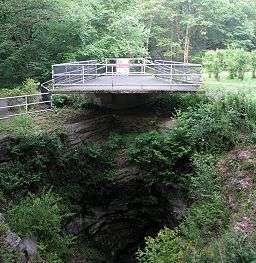
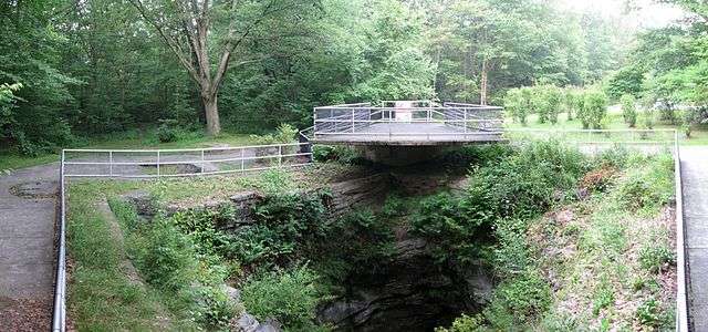
Archbald Pothole State Park is a 149.16-acre (60.36 ha) Pennsylvania state park in Archbald, Lackawanna County, Pennsylvania. The focal point of the park is Archbald Pothole. The pothole is a remnant of the Wisconsin Glacial Period, 38 feet (11.6 m) deep with a largest diameter of 42 feet (12.8 m) by 24 feet (7.3 m). It has drawn tourists since just after it was discovered in 1884. Archbald Pothole State Park is on U.S. Route 6 Business in the borough of Archbald.
History
A coal miner, Patrick Mahon, discovered Archbald Pothole in 1884. Mahon was extending a mine shaft. When he set off a blast of explosives, water and stones came pouring into the mine shaft. He and the other miners fled the scene fearing for their lives. The manager of the mining company, Edward Jones, came to investigate. Jones ordered that the area be cleared of the fallen debris. Almost 1,000 tons of small rounded stones were removed and Jones soon realized that the vertical tunnel discovered by the coal miners, was a large pothole.[2]
After serving as a ventilation shaft for the mine, the pothole was fenced in by the owner of the land, Colonel Hackley, for tourists to look at it. The pothole soon became a renowned tourist attraction. Edward Jones led the tours for the locals and famous geologists. Archbald Pothole was turned over to public ownership in 1914, when the widow of Colonel Hackley deeded 1-acre (4,000 m2) surrounding the pothole to the Lackawanna Historical Society. Lackawanna County gained ownership of the pothole and the surrounding 150 acres (61 ha) in 1940. Archbald Pothole was a county park until 1961 when the property was transferred to the Commonwealth of Pennsylvania. Archbald Pothole State Park was formally opened in 1964.[2]
While the pothole and surrounding park were long a popular tourist attraction, by the 1990s attendance had fallen and the facilities were in need of repair. The park was closed for a $170,000 "facelift" and when it reopened in 1997 it had been repaved and had new landscaping and new trash receptacles.[3][4] Despite the improvements, attendance remained low and litter thrown into the pothole was still a problem, including "bottles and paper bags... a parking meter, a park bench and a "Wet Floor" cone".[4] Another problem was the park's "unsavory reputation" as a place for "men looking for sex", with plainclothes police arresting 29 men there for "lewd behavior" in one 2002 sweep.[4] In an attempt to address these issues, in 2002 the Pennsylvania State Legislature approved more improvements to the park, including "least two soccer fields, a basketball court, a tennis court, a walking trail, a playground, roads and parking areas".[4]
Geology
Archbald Pothole is 38 feet (11.6 m) deep and 42 feet (12.8 m) wide at its maximum diameter. The pothole cuts through layers of sandstone, shale and coal. A pothole, in geologic terms, is a hole that is worn into the bedrock of a stream in strong rapids or at the base of a waterfall. The force of the water spins rock fragments, sand and gravel into a small indentation in the bedrock. After years and years of constant spinning, the stones and sands carve out an elliptical hole. Potholes are also formed by the action of glacial meltwater. Archbald Pothole is an example of just such a pothole.[5]
Archbald Pothole was formed during the Wisconsin Glacial Period. As the glacier melted, a stream that flowed on top may have fallen into a crevasse and then fell to the bedrock. The force of the falling water created a pothole in much the same way that a waterfall creates a pothole. The pothole was filled by falling sand, rocks and gravel as the glacier retreated and created other potholes. Archbald Pothole was preserved underground for nearly 13,000 years until its discovery by Patrick Mahon.[5] The park is at an elevation of 1,211 feet (369 m).[1]
Nearby glacial formations
- Hickory Run State Park - Hickory Run State Park is in the nearby Pocono Mountains. There are 14 acres (5.7 ha) of jumbled stone caused by the actions of the glaciers during the latest glacial period. The glacial moraine crosses the park.[6]
- Seven Tubs Natural Area - The Seven Tubs Natural Area is about four miles (6 km) southeast of downtown Wilkes-Barre. Also known as Whirlpool Valley, Seven Tubs is a series of potholes eroded into the bedrock. A hiking trail passes by the seven tub-shaped potholes. Seven Tubs Natural Area is owned by Luzerne County. It is a popular, but dangerous swimming hole for the daredevils of the area.[7]
- Tannersville Cranberry Bog - Tannersville Cranberry Bog is in Pocono Township, Monroe County. This bog, owned by The Nature Conservancy, is the southernmost low-altitude hemiboreal bog. The bog is home to rare orchids and some carnivorous plants like sundew and the pitcher plant.[8]
Recreation
A small loop trail follows an old coal mine tram road for hiking. The trail passes along a rock ledge and through a forest.[2]
Hunting is permitted on over 100 acres (40 ha) of the park. The most common game species are squirrels, turkeys and white-tailed deer. The hunting of groundhogs is not permitted. Hunters are expected to follow the rules and regulations of the Pennsylvania State Game Commission.[2]
Some of the parkland was stripped off in the past by strip mining. This land is currently undergoing a reclamation process and there are plans to use the reclaimed land for recreation and to build athletic fields.[2]
Nearby state parks
The following state parks are within 30 miles (48 km) of Archbald Pothole State Park:[9][10][11]
- Frances Slocum State Park (Luzerne County)
- Gouldsboro State Park (Monroe and Wayne Counties)
- Lackawanna State Park (Lackawanna County)
- Promised Land State Park (Pike County)
- Prompton State Park (Wayne County)
- Tobyhanna State Park (Monroe County)
- Varden Conservation Area (Wayne County)
References
- 1 2 "Archbald Pothole State Park". Geographic Names Information System. United States Geological Survey. August 30, 1990. Retrieved April 2, 2008.
- 1 2 3 4 5 "Archbald Pothole State Park". Pennsylvania Department of Conservation and Natural Resources. Retrieved October 25, 2006.
- ↑ "National Briefing: Mid-Atlantic: Pennsylvania: A Money Pit". New York Times. July 23, 2002. Retrieved April 8, 2008.
- 1 2 3 4 "Biggest pothole falls on hard times". Amarillo Globe-News / Associated Press. August 2, 2002. Retrieved April 7, 2008.
- 1 2 "Geologic Survey". Pennsylvania Department of Conservation and Natural Resources. Retrieved October 25, 2006.
- ↑ "Hickory Run State Park". Pennsylvania Department of Conservation and Natural Resources. Archived from the original on 17 March 2007. Retrieved March 26, 2007.
- ↑ "Seven Tubs Natural Area, Luzerne County". Green Treks Network, Inc. Retrieved October 25, 2006.
- ↑ "Tannersville Cranberry Bog". The Nature Conservancy. Archived from the original on 27 October 2006. Retrieved October 25, 2006.
- ↑ "2007 General Highway Map Lackawanna County Pennsylvania" (PDF) (Map). 1:65,000. Pennsylvania Department of Transportation, Bureau of Planning and Research, Geographic Information Division. Retrieved July 27, 2007.
- ↑ Michels, Chris (1997). "Latitude/Longitude Distance Calculation". Northern Arizona University. Archived from the original on 11 April 2008. Retrieved April 15, 2008.
- ↑ "Find a Park by Region (interactive map)". Pennsylvania Department of Conservation and Natural Resources. Retrieved November 17, 201. Check date values in:
|access-date=(help)
External links
| Wikimedia Commons has media related to Archbald Pothole State Park. |
- "Archbald Pothole State Park official map" (PDF). (272 KB)