Gifford Pinchot State Park
| Gifford Pinchot State Park | |
|---|---|
| Pennsylvania State Park | |
| Natural Monument (IUCN III) | |
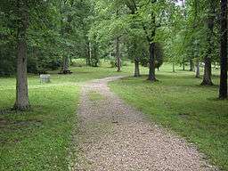 The picnic area in Gifford Pinchot State Park | |
| Named for: Gifford Pinchot | |
| Country | United States |
| State | Pennsylvania |
| County | York |
| Township | Warrington |
| Location | [1] |
| - coordinates | 40°04′18″N 76°53′18″W / 40.07167°N 76.88833°WCoordinates: 40°04′18″N 76°53′18″W / 40.07167°N 76.88833°W |
| - elevation | 492 ft (150.0 m) [1] |
| Area | 2,238 acres (906 ha) |
| Founded | 1961 |
| Managed by | Pennsylvania Department of Conservation and Natural Resources |
 Location of Gifford Pinchot State Park in Pennsylvania | |
| Website : Gifford Pinchot State Park | |
Gifford Pinchot State Park is a 2,238-acre (906 ha) Pennsylvania state park in Warrington Township, York County, Pennsylvania in the United States. The park contains wooded hillsides, reverting farm fields, and 340-acre (140 ha) Pinchot Lake.[2] It is near York and Harrisburg in the south-central part of the state.
The park is named after former Pennsylvania Governor Gifford Pinchot. Pinchot was governor from 1923-1927 and 1931-1935. Gifford Pinchot National Forest in Washington state bears his name as well. The park was dedicated in 1961 by Governor David L. Lawrence.[3]
Recreation
Trails
There are more than 18 miles (29 km) of marked, maintained trails within the Gifford Pinchot State Park. Most of them interconnect. The trails are classified in one of three categories, easy, moderate, and difficult.[3]
Easy trails[3]
- Alpine Trail: 0.5 miles (800 m), a wide gravel path known for its wildflowers. This trail begins on the east side of Conewago Day Use Area.
- Gravel Trail: 1.2 miles (1.9 km), this wide trail follows an old woods road and has a gravel surface.
- Oak Trail: 0.4 miles (640 m), a short trail that connects the campground with the interpretive center at the western end of the Conewago Day Use Area.
- Old Farm Trail: 1 mile (1.6 km), follows an old farm road to the top of Straight Hill. Connects Lakeside, Oak, and Ridge Trails.
Moderate trails[3]
- Midland Trail: 0.5 miles (800 m), a trail with dirt and rock surfaces and steeper slopes, runs through most mature forest in the park.
- Fern Trail: 0.5 miles (800 m), another trail with rock and dirt surfaces as well as steeper slopes, runs through same mature forest as Midland.
- Quaker Race Trail: 1.7 miles (2.7 km), best reached through Quaker Race Day Use Area This trail has a dirt or rocky surfaces, uneven terrain and one steep hill.
- Ridge Trail: 1.2 miles (1.9 km), the trail wanders through old overgrown pasture, then climbs into a maturing oak and hickory forest along the top of Straight Hill. It has a dirt and rock surface. Butterflies are abundant along this trail.
Difficult trails[3]
- Beaver Creek Trail: 1.5 miles (2.4 km), a trail that goes through wooded terrain. Sections of the trail can also be rocky or muddy when wet. Many habitats, including wetlands, can be seen in this undeveloped section of the park.
- Lakeside Trail: 8.5 miles (13.7 km), longest trail in the park. The walk is about six hours and some of the remote sections of the trail are narrow and have uneven footing.
- Pinchot Trail: 1.4 miles (2.3 km), rocky and/or wet surfaces. The habitat is mostly maturing oak and hickory forest. A number of old stone walls provide reminders of long abandoned efforts at farming.
- Mason-Dixon Trail: 200 miles (320 km), this trail passes through Delaware, Maryland and Pennsylvania
Water Activities
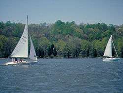
The 340-acre (140 ha) Pinchot Lake provides opportunities for boating. It has 24-hour launch areas and 286 shore moorings and canoe racks that can be rented from April 1 to November 1, the boat rental also rents electric motors and trolling engines for boats. Boats using the lake, with a motor must display a boat registration from any state. Non-powered boats must display one of the following: boat registration from any state,launching permit or mooring permit from Pennsylvania State Parks that are available at most state park offices, launch use permit from the Pennsylvania Fish and Boat Commission.[3]
Pinchot Lake holds largemouth bass, hybrid striped bass, muskellunge, catfish, carp, walleye, crappie and sunfish. It is a Pennsylvania Big Bass Lake and thus, special regulations cover minimum size and creel limits for all species of bass. During the winter months, when conditions permit, ice fishing is allowed on the lake. Ice fishermen mostly catch largemouth bass and the occasional walleye, muskellunge, crappie or sunfish.[3]
The park also boasts a large beach in the Quaker Race Day Use Area. It is open from mid-May to mid-September. Beginning in 2008 lifeguards will not be posted at the beach.[4] During the winter, when conditions permit, ice skating and ice boating are allowed on Pinchot Lake, as well.[3]
Hunting
Around 1,780 acres (720 ha) are open to hunting, trapping and the training of dogs from fall archery season through the end of the traditional winter seasons at Gifford Pinchot State Park. The most common game species are White-tailed deer, rabbit, waterfowl and squirrel. Hunting is restricted to bows and arrows only until the traditional small game season begins, then muzzleloaders and shotguns are allowed. Handguns and center fire rifles are never allowed in the park. Hunting is prohibited during the spring and summer and dog training can go on in designated hunting areas from Labor Day until March 31.[3]
Picnicking
On the west side of the lake is Quaker Race Day Use Area and on the east side Conewago Day Use Area. They both contain charcoal grills, picnic table, parking lots, restrooms, horseshoe pits and drinking water. Quaker Race area has a volleyball court and Conewago, a softball field. Picnic pavilions may be reserved up to 11 months in advance for a fee.[3]
Horseback riding
There are no horse rentals but there is a northeast section of the park set aside for horseback riding. There are several miles of interconnecting, mowed trails that wind through reverting farm fields, pine plantations and deciduous woodlands.[3]
Disc Golf
The focus of Pinchot Disc Golf is to provide an opportunity for the public to learn about Disc Golf and encourage the public to become regular participants in Disc Golf as a wholesome, outdoor, low-impact, and fun exercise![3]
Boulder Woods: The Boulder Woods recreational course is perfect for those who want to develop their Disc Golf skills or to compete in Amateur Disc Golf events. The 18-hole Boulder Woods Recreational Disc Golf Course is located in the Conewago Day Use Area, off Alpine Road, at Gifford Pinchot State Park.[3]
Quaker's Challenge: A new, 18-hole championship length, Disc Golf course is currently under construction on the west side of the lake in the Quaker Race Day Use Area with an expected completion date of Fall 2007, however, the course is currently playable as of August 2007. The championship course will be a great option for those seeking longer and more challenging Disc Golf holes.[3]
Both courses are open to the public and are free to play. Score cards and course maps are available on-site.[3]
Geology
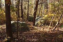

Most of the park is underlain by Triassic diabase, an igneous rock, and the many large, rounded boulders within the park are made of this material. Approximately 180 million years ago, the diabase intruded into older Triassic sedimentary rocks of the Gettysburg Formation, consisting of red sandstone and shale. Along the contacts of the diabase and sedimentary rocks, the molten diabase heated the sedimentary rocks to metamorphic rocks.[5][6]
Nearby state parks
The following state parks are within 30 miles (48 km) of Gifford Pinchot State Park:[7][8][9]
- Boyd Big Tree Preserve Conservation Area (Dauphin County)
- Codorus State Park (York County)
- Joseph E. Ibberson Conservation Area (Dauphin County)
- Kings Gap Environmental Education and Training Center (Cumberland County)
- Memorial Lake State Park (Lebanon County)
- Pine Grove Furnace State Park (Cumberland County)
- Samuel S. Lewis State Park (York County)
References
- 1 2 "Gifford Pinchot State Park". Geographic Names Information System. United States Geological Survey. August 2, 1979. Retrieved 2008-03-06.
- ↑ "Pinchot Lake". Geographic Names Information System. United States Geological Survey. August 30, 1990. Retrieved 2016-05-10.
- 1 2 3 4 5 6 7 8 9 10 11 12 13 14 15 "Gifford Pinchot State Park". Pennsylvania Department of Conservation and Natural Resources. Retrieved 2007-03-24.
- ↑ "Pa. state parks going without life guards at beaches in 2008". The Times Leader. Retrieved 2008-03-06.
- ↑ Hoskins, D. M. Pennsylvania Trail of Geology: Gifford Pinchot State Park. Park Guide 10. Commonwealth of Pennsylvania, Department of Conservation and Natural Resources.
- ↑ Wood, C. R., 1980, Groundwater resources of the Gettysburg and Hammer Creek Formations, southeastern Pennsylvania: Pennsylvania Geological Survey, 4th ser., Water Resource Report 49, 87 p. (web release).
- ↑ 2007 General Highway Map York County Pennsylvania (PDF) (Map). 1:65,000. Pennsylvania Department of Transportation, Bureau of Planning and Research, Geographic Information Division. Retrieved 2007-07-28. Note: shows Gifford Pinchot State Park
- ↑ Michels, Chris (1997). "Latitude/Longitude Distance Calculation". Northern Arizona University. Retrieved 2008-04-20.
- ↑ "Find a Park by Region (interactive map)". Pennsylvania Department of Conservation and Natural Resources. Retrieved November 18, 2011.
External links
| Wikimedia Commons has media related to Gifford Pinchot State Park. |
- "Gifford Pinchot State Park official map" (PDF). (609 KB)