Kinzua Bridge State Park
| Kinzua Bridge State Park | |
|---|---|
| Pennsylvania State Park | |
| Natural Monument (IUCN III) | |
 A view of the collapsed Kinzua Bridge taken May 2007. | |
| Named for: Kinzua Bridge | |
| Country | United States |
| State | Pennsylvania |
| County | McKean |
| Townships | Hamlin, Keating |
| Location | [1] |
| - coordinates | 41°45′19″N 78°35′01″W / 41.75528°N 78.58361°WCoordinates: 41°45′19″N 78°35′01″W / 41.75528°N 78.58361°W |
| - elevation | 2,136 ft (651.1 m) [1] |
| Area | 329 acres (133 ha) |
| Founded | 1963 [2] |
| Managed by | Pennsylvania Department of Conservation and Natural Resources |
 Location of Kinzua Bridge State Park in Pennsylvania | |
| Website : Kinzua Bridge State Park | |

Kinzua Bridge State Park is a 329-acre (133 ha) Pennsylvania state park near Mount Jewett, in Hamlin and Keating Townships, McKean County, Pennsylvania in the United States. The park lies between U.S. Route 6 and Pennsylvania Route 59, along State Route 3011 just east of the Allegheny National Forest.[2][3]
Kinzua Bridge State Park was chosen by the Pennsylvania Department of Conservation and Natural Resources (DCNR) and its Bureau of Parks as one of "25 Must-See Pennsylvania State Parks".[4]
Kinzua Bridge
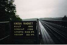
The park is noted as the site of the Kinzua Bridge spanning Kinzua Creek, original bridge built in 1882, subsequent bridge built in 1900 and destroyed in 2003 by a tornado. At the time it was built, the original (c. 1882) Kinzua Bridge was the highest, at 301 feet (92 m), and longest, at 2,053 feet (626 m), railway bridge in the world, given the distinction of being listed as a Historic Civil Engineering Landmark (the listing was in 1977). The Erie Railroad company originally owned and operated the bridge.[2]
William Scranton, then governor of Pennsylvania, signed legislation creating Kinzua Bridge State Park in 1963, although the park did not officially open until 1970.[2] In 1987, excursion trains of the Knox and Kane Railroad again began running on the bridge. The trains traveled from Kane with a trip through the Allegheny National Forest and made a stop on the bridge before returning to Kane.[2]
The Knox and Kane Railroad offered excursion rail trips across the bridge until June, 2002, when it was closed for restoration. At approximately 3:20 p.m., July 21, 2003, a tornado from the east touched down at the park. The storm, classified as F-1 on the Fujita scale, tore down 11 of the 20 structure spans and nearby trees were snapped and uprooted. The failure was caused by badly rusted bolts holding the bases of the towers. The investigation reckoned that the whole structure oscillated laterally 4-5 times before fatigue broke the base bolts. The towers fell intact in sections, and they suffered impact damage with the ground. They have been left as they fell, and it is intended to make the ruins a visitor attraction to show the forces of nature at work. [5]
In 2011, the engineering masterpiece was reinvented as the Kinzua Bridge Skywalk, a new pedestrian walkway where visitors can stroll 600 feet out on the remaining support towers, peer miles out into the Kinzua Gorge as well as peer down into the partial glass platform at the end of the walkway.
Recreation

A scenic view overlooks the fallen bridge and Kinzua Creek Valley. The overlook is also a prime location to view the fall foliage during the first two weeks of October. The park also has a shaded picnic area with a centrally located modern restroom.[2]
There are 100 acres (40 ha) of woods open to hunting at Kinzua Bridge State Park. Hunters are expected to follow the rules and regulations of the Pennsylvania Game Commission. The common game species are black bears, eastern gray squirrel, white-tailed deer, and wild turkey. The hunting of groundhogs is prohibited.[2]
Nearby state parks
The following state parks are within 30 miles (48 km) of Kinzua Bridge State Park:[6][7][8]
- Allegany State Park (New York)
- Bendigo State Park (Elk County)
- Bucktail State Park Natural Area (Cameron and Clinton Counties)
- Chapman State Park (Warren County)
- Elk State Park (Elk County)
- Sizerville State Park (Cameron and Potter Counties)
References
- 1 2 "Kinzua Bridge State Park". Geographic Names Information System. United States Geological Survey. August 2, 1979. Retrieved 2008-03-29.
- 1 2 3 4 5 6 7 "Kinzua Bridge State Park". Pennsylvania Department of Conservation and Natural Resources. Retrieved 2007-10-04.
- ↑ McKean County (Map). Cartography by Pennsylvania Department of Transportation. Pennsylvania Department of Transportation. 2007.
- ↑ "Find a Park: 25 Must-see Parks". Pennsylvania Department of Conservation and Natural Resources. Retrieved May 26, 2015.
- ↑ "DNCR report on the collapse of the Kinzua Viaduct". Pennsylvania Department of Conservation and Natural Resources. Retrieved 2005-06-11.
- ↑ "Find a Park by Region (interactive map)". Pennsylvania Department of Conservation and Natural Resources. Retrieved November 18, 2011.
- ↑ 2007 General Highway Map McKean County Pennsylvania (PDF) (Map). 1:65,000. Pennsylvania Department of Transportation, Bureau of Planning and Research, Geographic Information Division. Retrieved 2007-07-28. Note: shows Kinzua Bridge State Park
- ↑ Michels, Chris (1997). "Latitude/Longitude Distance Calculation". Northern Arizona University. Retrieved 2008-04-23.
External links
| Wikimedia Commons has media related to Kinzua Bridge State Park. |
- "Kinzua Bridge State Park Official map" (PDF). (249 KB)