Johnstown Flood National Memorial
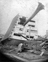
Johnstown Flood National Memorial commemorates the approximately 2,200 people who died in the Johnstown Flood on May 31, 1889, caused by a break in the South Fork Dam, an earthen structure. The memorial is located at 733 Lake Road near South Fork, Pennsylvania, about 10 miles (16 km) northeast of Johnstown. The memorial preserves the remains of the dam and portions of the former Lake Conemaugh bed. The United States Congress authorized the national memorial on August 31, 1964.
References
External links
|
|---|
|
| Topics | | |
|---|
|
| Lists by county | |
|---|
|
| Lists by city | |
|---|
|
| Other lists | |
|---|
|
-
 Category Category
-
 NRHP portal NRHP portal
|
|
|---|
|
| Metro Area | |
|---|
|
| History/Attractions | |
|---|
|
| Transportation | |
|---|
|
| Education | |
|---|
|
| Industry | |
|---|
|
| Entertainment/Sports | |
|---|
|
| Media/Pop Culture | |
|---|
|
| Television |
- WPSU (3.1 PBS, 3.2 Create, 3.3 World)
- WJAC (6.1 NBC, 6.2 MeTV, 6.3 Comet, 6.4 Grit)
- WWCP (8.1 Fox, 8.2 WATM)
- WTAJ (10.1 CBS, 10.2 Escape, 10.3 Laff)
- WSCP-LP (13 Ind)
- WPCW (19.1 CW)
- WATM (23.1 ABC HD, 23.2 WWCP-TV HD, 23.3 This TV, 23.4 ATV)
- WHVL-LP (29.1 MNTV, 29.2 Buzzr)
- W36BE-D (36.1 ABC, 36.2 ATV, 36.3 Justice)
- WKBS (47.1 COR)
|
|
|---|
|
| Radio | |
|---|


