Banc d'Arguin National Park
| Banc d'Arguin National Park | |
|---|---|
|
IUCN category VI (protected area with sustainable use of natural resources) | |
|
Map of the bay showing the Banc d'Arguin National Park | |
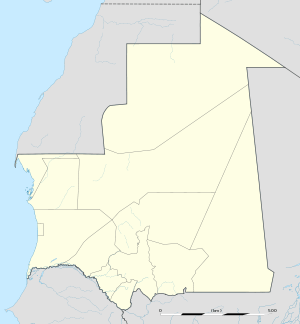 Banc d'Arguin National Park in Mauritania | |
| Location | Mauritania |
| Nearest city | Nouakchott and Nouadhibou |
| Coordinates | 20°14′N 16°06′W / 20.233°N 16.100°WCoordinates: 20°14′N 16°06′W / 20.233°N 16.100°W |
| Area | 12,000 km2 |
| Established | 1978 |
| Governing body | IUCN |
| Type | Natural |
| Criteria | ix, x |
| Designated | 1989 (13th session) |
| Reference no. | 506 |
| State Party |
|
| Region | Arab States |
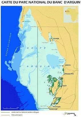
The Banc d'Arguin National Park (French: Parc National du Banc d'Arguin) of Bay of Arguin lies in Western Africa on the west coast of Mauritania between Nouakchott and Nouadhibou. The World Heritage Site is a major breeding site for migratory birds, including flamingos, broad-billed sandpipers, pelicans and terns. Much of the breeding is on sand banks including the islands of Tidra, Niroumi, Nair, Kijji and Arguim. The surrounding waters are some of the richest fishing waters in western Africa and serve as nesting grounds for the entire western region.
The Banc d'Arguin National Park is a Nature reserve that was established to protect both the natural resources and the valuable fisheries, which makes a significant contribution to the national economy (Hoffmann, 1988), as well as scientifically and aesthetically valuable geological sites, in the interests of and for the recreation of the general public. The park's vast expanses of mudflats provide a home for over two million migrant shorebirds from northern Europe, Siberia and Greenland. The region's mild climate and absence of human disturbance makes the park one of the most important sites in the world for these species. The nesting bird population is also noted for its great numbers and diversity. Between 25,000 and 40,000 pairs belonging to 15 species, making the largest colonies of water birds in West Africa (IUCN Technical Evaluation, 1989).
Conservation
Although the park was constituted as a way to protect its environment, overfishing by international fleets in the waters just off Banc d'Arguin, outside the park, is depleting fish resources and may cause a decline of the breeding colonies of fish-eating bird species (Mepham and Mepham, in press). In 2006 Mauritania sold to the EU fishing rights in exchange for external debt reduction, prompting arguments of overfishing, sustainability, Neocolonialism, and the rights of local people.
People
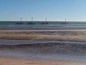
The local population comprises about 500 or so Imraguen tribesmen that live in seven villages within the park. They base their economy on subsistence fishing using traditional methods.
Fauna
The park is host to one of the world's most diversified communities of nesting piscivorous birds in the world (Hoffmann, 1988). At least 108 bird species have been recorded, representing both Palaearctic and Afrotropical realms. Wintering shorebirds number over three million and include hundreds of thousands of black tern (Chlidonias nigra) and flamingo (Phoenicopterus ruber), ringed plover (Charadrius hiaticula), grey plover (Pluvialis squatarola), red knot (Calidris canutus), common redshank (Tringa totanus) and bar-tailed godwit (Limosa lapponica).
Along with the regions in north such as the Cintra Bay and Dakhla Peninsula, the area is one of the most important wintering grounds for Eurasian spoonbill (Platalea leucorodia leucorodia). Breeding birds include white pelican (Pelecanus onocrotalus), reed cormorant (Phalacrocorax africanus), gull-billed tern (Gelochelidon nilotica), Caspian tern (Hydroprogne caspia), royal tern (Sterna maxima) and common tern (Sterna hirundo), together with several species or subspecies with an African distribution, such as heron (Ardea cinerea monicae) and Eurasian spoonbill (Platalea leucorodia balsaci) and western reef heron (Egretta gularis) (IUCN, 1987).
For marine mammals, endangered species can be seen here all-year round; for example, Mediterranean monk seals, Atlantic humpback dolphins and bottlenose dolphins.[1] Other species can be seen here are orca, the killer whales, pilot whales, Risso's dolphins, dolphins (common, rough-toothed). Fin whales and harbor porpoises are also known to visit the area. Possibly, highly coastal whale species such as North Atlantic right whales,[2] now-extinct Atlantic gray whales were used to be seen here as well.[3] Other baleen whales possibly occur here include; humpbacks, seis, blues,[4] Brydes', and minkes,[5] as they have been seen in either coastal or offshore waters.[6][7]
Flora
The Coastal Zone, or Sub-Canarian Zone, extends the length of the approximately 754-kilometer-long Atlantic coast. Prevailing oceanic trade winds from the Canary Islands modify the influence of the harmattan, producing a humid but temperate climate. Rainfall here is minimal; in Nouadhibou it averages less than three centimeters annually and occurs between July and September. Temperatures are moderate, varying from mean maxima of 28 °C and 32 °C for Nouadhibou and Nouakchott, respectively, to mean minima of 16 °C and 19 °C.
Battering surf and shifting sand banks characterize the entire length of the shoreline. The Ras Nouadhibou (formerly Cap Blanc) peninsula, which forms Dakhlet Nouadhibou (formerly Lévrier Bay) to the east, is fifty kilometers long and up to thirteen kilometers wide. The peninsula is administratively divided between Western Sahara (see Glossary) and Mauritania, with the Mauritanian port and railhead of Nouadhibou located on the eastern shore (see fig. 11). Dakhlet Nouadhibou, one of the largest natural harbors on the west coast of Africa, is forty-three kilometers long and thirty-two kilometers wide at its broadest point. Fifty kilometers southeast of Ras Nouadhibou is Arguin. In 1455 the first Portuguese installation south of Cape Bojador (in the present-day Western Sahara) was established at Arguin. Farther south is the coastline's only significant promontory, seven-meter-high Cape Timiris. From this cape to the marshy area around the mouth of the Senegal River, the coast is regular and marked only by an occasional high dune.
On coastal dunes vegetation is rare. At the foot of ridges, however, large tamarisk bushes, dwarf acacias, and swallowworts may be found. Some high grass, mixed with balsam, spurge, and spiny shrubs, grows in the central region. The north has little vegetation.
Geology
The depositional profile of the northern Banc d'Arguin describes a flat-topped platform, on which extensive carbonate deposits developed largely in water depths <10 meters below sea level (mbsl). Vast areas of the Banc d'Arguin are covered by mixed carbonate–siliciclastic sediments dominated by barnacles and mollusk remains plus admixed eolian siliciclastics. These sediments accumulate into extensive shoals, occasionally causing water depths below 5 mbsl several dozens kilometers offshore the present shoreline. The bank edge forms a sharp morphological step, suddenly deepening from 10–20 mbsl down to 30–50 mbsl, and separates the inner shelf environments (<5–10 mbsl; carbonate bank) from those of the outer shelf. Assemblages formed by benthic foraminifers and mollusks and monospecific bivalve shell accumulations with admixed eolian silt characterize the platform cover in the outer shelf.[8]
In the central and southern outermost shelf, silt-sized quartzose materials form confined bodies referred to as the Arguin and Timiris Mud Wedges. These deposits started to form with transgressional inundation early in the Holocene and have grown continuously and rapidly over the past 9 kyrs. Locally, the mud wedge deposits are incised by gullies and canyons towards the shelf break lying at around 80–110 mbsl. The southernmost Golfe d'Arguin describes a homoclinal ramp profile with vast intertidal plains around Tidra Island.[9]
History

Because of its rich fishery and strategic location, the territory has been highly coveted and disputed by the European colonial powers of Portugal, France, England, Prussia/Germany and Holland.
- Arguin Island
| 1445 – 5 February 1633 | Portuguese rule (Arguim). |
| 5 February 1633 – 1678 | Dutch rule (brief English occupation in 1665). |
| 1 September 1678 – September 1678 | French occupation. |
| September 1678 | Abandoned. |
| 5 October 1685 – 7 March 1721 | Brandenburg (from 1701, Prussian) rule. |
| 7 March 1721 – 11 January 1722 | French rule. |
| 11 January 1722 – 20 February 1724 | Dutch rule. |
| 20 February 1724 – March 1728 | French rule. |
- The Wreck of Medusa – La Méduse was a French frigate that ran aground at high tide off Banc d'Arguin on 2 July 1816.
A scene inspired by the account of survivors Alexandre Corréard and Jean-Baptiste-Henri Savigny was made the subject of a painting in 1819 by Théodore Géricault called "The Raft of the Medusa", which is displayed in the Louvre Museum in Paris, France.
.jpg)
Despite the Almoravid domination of Spain in the eleventh and twelfth centuries, there seems to be little evidence of contact during that time between Mauritania and Europe. The inhospitable coastline of Mauritania continued to deter voyagers until the Portuguese began their African explorations in the fifteenth century. Lured by legends of vast wealth in interior kingdoms, the Portuguese established a trading fort at Arguin, southeast of Cap Blanc (present-day Ras Nouadhibou), in 1455. The king of Portugal also maintained a commercial agent at Ouadane in the Adrar in an attempt to divert gold traveling north by caravan. Having only slight success in their quest for gold, the Portuguese quickly adapted to dealing in slaves. In the mid-fifteenth century, as many as 1,000 slaves per year were exported from Arguin to Europe and to the Portuguese sugar plantations on the island of São Tomé in the Gulf of Guinea.
With the merger of the Portuguese and Spanish crowns in 1580, the Spaniards became the dominant influence along the coast. In 1638, however, they were replaced by the Dutch, who were the first to begin exploiting the gum arabic trade. Produced by the acacia trees of Trarza and Brakna and used in textile pattern printing, this gum arabic was considered superior to that previously obtained in Arabia. By 1678 the French had driven out the Dutch and established a permanent settlement at Saint Louis at the mouth of the Senegal River, where the French Company of the Senegal River (Compagnie Française du Sénégal) had been trading for more than fifty years.
The Maures Eng:(Moors), with whom the Europeans were trading with, considered the constant rivalries between European powers a sign of weakness, and they quickly learned the benefits of playing one power against the other. For example, they agreed simultaneously to give monopolies to the French and the Dutch. The Maures also took advantage of the Europeans whenever possible, so that when the French negotiated with the amir of Trarza to secure a monopoly on the gum Arabic trade, the amir in exchange demanded a considerable number of gifts. Thus began the custom, an annual payment expected by the Maures for doing business with a government or a company. By 1763 the British had expelled France from the West African coast, and France recovered control only when the Congress of Vienna in 1815 recognized French sovereignty over the coast of West Africa from Cap Blanc south to Senegal.
References
- ↑ Hoyt E. "Marine Protected Areas for Whales, Dolphins and Porpoises: A World Handbook for Cetacean Habitat Conservation and Planning". p. 249. Retrieved 25 April 2014.
- ↑ Duke University (2008). "Spatial Ecology of the North Atlantic Right Whale (Eubalaena Glacialis)." (book). The ProQuest. Retrieved 2015-12-04.
- ↑ https://www.researchgate.net/publication/273330281_Climate_impacts_on_transocean_dispersal_and_habitat_in_gray_whales_from_the_Pleistocene_to_2100
- ↑ Blue whale news (2015). "Ten blue whales sighted off Mauritania, probably migrated from Iceland (!)". The Twitter. Retrieved 2015-10-15.
- ↑ WAEREBEEK V.K.; ANDREi M.; SEQUEIRAi M.; MARTIN V.; ROBINEAU D.; COLLET A.; NDIAYE E.P.V. "Spatial and temporal distribution of the minke Whale,Balaenoptera acutorostrata (Lacépede, 1804), in the southernnortheast Atlantic Ocean and the Mediterranean Sea, With reference to stock identity" (PDF). J. CETACEAN RES. MANAGE. l(3): 223–237. Retrieved 2014-12-20.
- ↑ Reichelt M.; Baines M. "Mauritania". Retrieved 2015-10-15.
- ↑ Burton C.; Camphuysen C.J.K. "Sea bird and cetacean surveys in the vicinity of the Chinguetti oil field, offshore Mauritania. March, 2003" (PDF). Bowman Bishaw Gorham and Woodside Energy Pty Ltd. Retrieved 25 April 2014.
- ↑ Klicpera, André; Michel, Julien; Westphal, Hildegard (25 November 2014). "Facies patterns of a tropical heterozoan carbonate platform under eutrophic conditions: the Banc d'Arguin, Mauritania". Facies. 61 (1). doi:10.1007/s10347-014-0421-5.
- ↑ Michel, Julien; Westphal, Hildegard; Hanebuth, Till J. J. (23 April 2009). "Sediment partitioning and winnowing in a mixed eolian-marine system (Mauritanian shelf)". Geo-Marine Letters. 29 (4): 221–232. doi:10.1007/s00367-009-0136-8.
External links
| Wikimedia Commons has media related to Banc d'Arguin National Park. |
| Wikivoyage has a travel guide for Banc d'Arguin National Park. |
- Official website of Banc d'Arguin Park
- Banc d'Arguin National Park UNESCO Site
- Banc d' Arguin - Google image search results
- Google Earth - Banc d'Arguin National Park - Bookmark & Site Borders
- Arguin: A Portuguese fort in Mauritania