Blanchardville, Wisconsin
| Blanchardville, Wisconsin | |
|---|---|
| Village | |
|
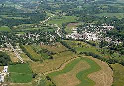
Aerial view of Blanchardville | |
 Location of Blanchardville, Wisconsin | |
| Coordinates: 42°48′37″N 89°51′42″W / 42.81028°N 89.86167°WCoordinates: 42°48′37″N 89°51′42″W / 42.81028°N 89.86167°W | |
| Country | United States |
| State | Wisconsin |
| Counties | Lafayette, Iowa |
| Area[1] | |
| • Total | 0.50 sq mi (1.29 km2) |
| • Land | 0.50 sq mi (1.29 km2) |
| • Water | 0 sq mi (0 km2) |
| Elevation[2] | 823 ft (251 m) |
| Population (2010)[3] | |
| • Total | 825 |
| • Estimate (2012[4]) | 825 |
| • Density | 1,650.0/sq mi (637.1/km2) |
| Time zone | Central (CST) (UTC-6) |
| • Summer (DST) | CDT (UTC-5) |
| Area code(s) | 608 608 |
| FIPS code | 55-08125[5] |
| GNIS feature ID | 1561917[2] |
Blanchardville is a village in Iowa and Lafayette counties in the U.S. state of Wisconsin. The population was 825 at the 2010 census. Of this, 648 were in Lafayette County, and 177 were in Iowa County.
The Iowa County portion of Blanchardville is part of the Madison Metropolitan Statistical Area.
History
The community was originally settled by members of the Church of Jesus Christ of Latter Day Saints (Strangite) in the early 1840s, who named it Zarahemla.[6][7] The Mormon settlers mined lead ore and farmed.[8] Blanchardville's first mill was built in 1840.[9]
In 1856, Alvin Blanchard moved to the area from his farm near Dodgeville. Along with Cyrus Newkirk, he platted the village which currently bears his name in 1857. The village received its first post office the next year.[10]
Geography
Blanchardville is located at 42°48′37″N 89°51′42″W / 42.81028°N 89.86167°W (42.810392, -89.861631).[11]
According to the United States Census Bureau, the village has a total area of 0.50 square miles (1.29 km2), all of it land.[1]
Demographics
| Historical population | |||
|---|---|---|---|
| Census | Pop. | %± | |
| 1880 | 169 | — | |
| 1900 | 573 | — | |
| 1910 | 643 | 12.2% | |
| 1920 | 653 | 1.6% | |
| 1930 | 651 | −0.3% | |
| 1940 | 662 | 1.7% | |
| 1950 | 707 | 6.8% | |
| 1960 | 632 | −10.6% | |
| 1970 | 794 | 25.6% | |
| 1980 | 803 | 1.1% | |
| 1990 | 802 | −0.1% | |
| 2000 | 806 | 0.5% | |
| 2010 | 825 | 2.4% | |
| Est. 2015 | 818 | [12] | −0.8% |
2010 census
As of the census[3] of 2010, there were 825 people, 360 households, and 228 families residing in the village. The population density was 1,650.0 inhabitants per square mile (637.1/km2). There were 396 housing units at an average density of 792.0 per square mile (305.8/km2). The racial makeup of the village was 98.9% White, 0.1% African American, 0.2% Asian, 0.2% from other races, and 0.5% from two or more races. Hispanic or Latino of any race were 1.2% of the population.
There were 360 households of which 31.4% had children under the age of 18 living with them, 47.2% were married couples living together, 10.0% had a female householder with no husband present, 6.1% had a male householder with no wife present, and 36.7% were non-families. 31.7% of all households were made up of individuals and 13.3% had someone living alone who was 65 years of age or older. The average household size was 2.29 and the average family size was 2.86.
The median age in the village was 40.8 years. 24.7% of residents were under the age of 18; 6.9% were between the ages of 18 and 24; 24.7% were from 25 to 44; 28.8% were from 45 to 64; and 14.9% were 65 years of age or older. The gender makeup of the village was 50.4% male and 49.6% female.
2000 census
As of the census[5] of 2000, there were 806 people, 346 households, and 206 families residing in the village. The population density was 1,837.4 people per square mile (707.3/km²). There were 376 housing units at an average density of 857.1 per square mile (329.9/km²). The racial makeup of the village was 99.38% White, 0.25% Asian, and 0.37% from two or more races. Hispanic or Latino of any race were 0.37% of the population.
There were 346 households out of which 28.6% had children under the age of 18 living with them, 50.9% were married couples living together, 7.2% had a female householder with no husband present, and 40.2% were non-families. 35.8% of all households were made up of individuals and 17.1% had someone living alone who was 65 years of age or older. The average household size was 2.33 and the average family size was 3.05.
In the village the population was spread out with 24.9% under the age of 18, 6.7% from 18 to 24, 29.8% from 25 to 44, 20.7% from 45 to 64, and 17.9% who were 65 years of age or older. The median age was 38 years. For every 100 females there were 98.5 males. For every 100 females age 18 and over, there were 96.4 males.
The median income for a household in the village was $40,313, and the median income for a family was $51,776. Males had a median income of $31,908 versus $26,208 for females. The per capita income for the village was $18,104. About 6.7% of families and 9.8% of the population were below the poverty line, including 9.6% of those under age 18 and 8.3% of those age 65 or over.
Education
Blanchardville is served by the Pecatonica Area Schools, which includes Pecatonica High School, Pecatonica Middle School and Pecatonica Elementary School.
Sports and recreation
- The Yellowstone Lake State Park is near Blanchardville.
Notable residents
- M. J. Cleary, state assemblyman and insurance executive
References
- 1 2 "US Gazetteer files 2010". United States Census Bureau. Archived from the original on 2012-01-24. Retrieved 2012-11-18.
- 1 2 "US Board on Geographic Names". United States Geological Survey. 2007-10-25. Retrieved 2008-01-31.
- 1 2 "American FactFinder". United States Census Bureau. Retrieved 2012-11-18.
- ↑ "Population Estimates". United States Census Bureau. Archived from the original on 2013-06-17. Retrieved 2013-06-24.
- 1 2 "American FactFinder". United States Census Bureau. Archived from the original on 2013-09-11. Retrieved 2008-01-31.
- ↑ "Blanchardville (origin of place name)" from the Dictionary of Wisconsin History, which misspelled Zarahemla as Zarahemia.
- ↑ "Church of Jesus Christ of Latter Day Saints in Wisconsin" from the Dictionary of Wisconsin History, which mentions the correct spelling of Zarahemla.
- ↑ "Mormons in Early Wisconsin (Historic Marker Erected 1992)" from the Dictionary of Wisconsin History
- ↑ "Blanchardville Loses Old Mill Build in '40" The Capital Times, March 9, 1930.
- ↑ "Blanchard, Alvin 1830 - 1910" from the Dictionary of Wisconsin History
- ↑ "US Gazetteer files: 2010, 2000, and 1990". United States Census Bureau. 2011-02-12. Retrieved 2011-04-23.
- ↑ "Annual Estimates of the Resident Population for Incorporated Places: April 1, 2010 to July 1, 2015". Retrieved July 2, 2016.
- ↑ "Census of Population and Housing". Census.gov. Archived from the original on May 11, 2015. Retrieved June 4, 2015.
External links
Municipalities and communities of Iowa County, Wisconsin, United States | ||
|---|---|---|
| Cities | 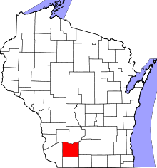 | |
| Villages | ||
| Towns | ||
| CDP | ||
| Unincorporated communities | ||
| Ghost towns | ||
| Footnotes | ‡This populated place also has portions in an adjacent county or counties | |
Municipalities and communities of Lafayette County, Wisconsin, United States | ||
|---|---|---|
| Cities |  | |
| Villages | ||
| Towns | ||
| CDP | ||
| Unincorporated communities | ||
| Footnotes | ‡This populated place also has portions in an adjacent county or counties | |