Blodgett Landing, New Hampshire
| Blodgett Landing, New Hampshire | |
|---|---|
| Census-designated place | |
|
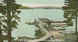
1905 postcard | |
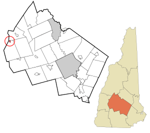 Location in Merrimack County and the state of New Hampshire. | |
| Coordinates: 43°22′25″N 72°2′31″W / 43.37361°N 72.04194°WCoordinates: 43°22′25″N 72°2′31″W / 43.37361°N 72.04194°W | |
| Country | United States |
| State | New Hampshire |
| County | Merrimack |
| Town | Newbury |
| Area | |
| • Total | 0.3 sq mi (0.8 km2) |
| • Land | 0.3 sq mi (0.8 km2) |
| • Water | 0.0 sq mi (0.0 km2) |
| Elevation | 1,120 ft (340 m) |
| Population (2010) | |
| • Total | 101 |
| • Density | 330/sq mi (130/km2) |
| Time zone | Eastern (EST) (UTC-5) |
| • Summer (DST) | EDT (UTC-4) |
| Area code(s) | 603 |
| FIPS code | 33-06020 |
| GNIS feature ID | 0871303 |
Blodgett Landing (frequently spelled Blodgetts Landing or Blodgett's Landing) is a census-designated place in the town of Newbury in Merrimack County, New Hampshire. It had a population of 101 at the 2010 census.[1]
It is located in the northern part of Newbury, between New Hampshire Route 103A and the shore of Lake Sunapee.
References
- ↑ United States Census Bureau, American FactFinder, 2010 Census figures. Retrieved March 23, 2011.
External links
Municipalities and communities of Merrimack County, New Hampshire, United States | ||
|---|---|---|
| Cities |  | |
| Towns | ||
| CDPs | ||
| Other unincorporated communities | ||
| Footnotes | ‡This populated place also has portions in an adjacent county or counties | |
This article is issued from Wikipedia - version of the 7/11/2016. The text is available under the Creative Commons Attribution/Share Alike but additional terms may apply for the media files.