Suncook, New Hampshire
| Suncook, New Hampshire | |
|---|---|
| Census-designated place | |
|
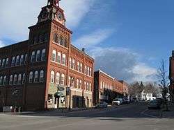
Center of Suncook village | |
 Location in Merrimack County and the state of New Hampshire. | |
| Coordinates: 43°7′51″N 71°27′10″W / 43.13083°N 71.45278°WCoordinates: 43°7′51″N 71°27′10″W / 43.13083°N 71.45278°W | |
| Country | United States |
| State | New Hampshire |
| County | Merrimack |
| Towns | Pembroke, Allenstown |
| Area | |
| • Total | 3.9 sq mi (10.0 km2) |
| • Land | 3.7 sq mi (9.6 km2) |
| • Water | 0.2 sq mi (0.4 km2) |
| Elevation | 269 ft (82 m) |
| Population (2010) | |
| • Total | 5,379 |
| • Density | 1,400/sq mi (540/km2) |
| Time zone | Eastern (EST) (UTC-5) |
| • Summer (DST) | EDT (UTC-4) |
| ZIP code | 03275 |
| Area code(s) | 603 |
| FIPS code | 33-75140 |
| GNIS feature ID | 0870274 |
Suncook is a census-designated place (CDP) in Merrimack County, New Hampshire, United States. The population was 5,379 at the 2010 census.[1] Approximately 2/3 of Suncook village is located in the town of Pembroke, with the remainder in Allenstown.[2]
The village of Suncook formed along the falls of the Suncook River, which drops 70 feet (21 m) in one-half mile (1 km) just before joining the Merrimack River. Much of the center of the village is occupied by 19th-century factory buildings which once used the river's energy for hydropower. The buildings have now largely been converted to other uses. Much of Suncook's late 19th-century commercial village center has been listed on the National Register of Historic Places.
Suncook was once home to the Suncook Valley Railroad, a short line railroad company that operated northwest to Concord and northeast to Barnstead. The railroad operated on former Boston and Maine track that was sold to the company. The Suncook Valley Railroad went bankrupt in 1952 and all its track was torn up.
Geography
Suncook is located at 43°07′51″N 71°27′10″W / 43.130833°N 71.452778°W.[3]
According to the United States Census Bureau, the CDP has a total area of 3.8 square miles (9.8 km2), of which 3.7 sq mi (9.6 km2) is land and 0.2 sq mi (0.52 km2) (3.91%) is water.
Demographics
As of the census[4] of 2000, there were 5,362 people, 2,338 households, and 1,386 families residing in the CDP. The population density was 1,452.1 people per square mile (561.1/km2). There were 2,409 housing units at an average density of 652.4 per square mile (252.1/km2). The racial makeup of the CDP was 97.11% White, 0.54% African American, 0.34% Native American, 0.45% Asian, 0.11% from other races, and 1.45% from two or more races. Hispanic or Latino of any race were 0.73% of the population.
There were 2,338 households out of which 29.2% had children under the age of 18 living with them, 43.9% were married couples living together, 11.4% had a female householder with no husband present, and 40.7% were non-families. 33.6% of all households were made up of individuals and 13.1% had someone living alone who was 65 years of age or older. The average household size was 2.29 and the average family size was 2.94.
In the CDP the population was spread out with 23.9% under the age of 18, 7.2% from 18 to 24, 33.2% from 25 to 44, 21.7% from 45 to 64, and 14.0% who were 65 years of age or older. The median age was 37 years. For every 100 females there were 92.6 males. For every 100 females age 18 and over, there were 87.4 males.
The median income for a household in the CDP was $41,973, and the median income for a family was $55,335. Males had a median income of $36,707 versus $25,590 for females. The per capita income for the CDP was $20,703. About 1.9% of families and 5.9% of the population were below the poverty line, including 4.5% of those under age 18 and 7.7% of those age 65 or over.
References
- ↑ United States Census Bureau, American FactFinder, 2010 Census figures. Retrieved March 23, 2011.
- ↑ U.S. Census Bureau. P.L. 94-171 County Block Maps (2010 Census)
- ↑ "The National Map". U.S. Geological Survey, MSR Maps. Retrieved 2008-06-09.
- ↑ "American FactFinder". United States Census Bureau. Retrieved 2008-01-31.
Further reading
- Laurence Armand French. Frog Town: Portrait of a French Canadian Parish in New England (2004) about the St. Jean-Baptiste parish Suncook. excerpt
Municipalities and communities of Merrimack County, New Hampshire, United States | ||
|---|---|---|
| Cities |  | |
| Towns | ||
| CDPs | ||
| Other unincorporated communities | ||
| Footnotes | ‡This populated place also has portions in an adjacent county or counties | |