South Hooksett, New Hampshire
| South Hooksett, New Hampshire | |
|---|---|
| Census-designated place | |
|
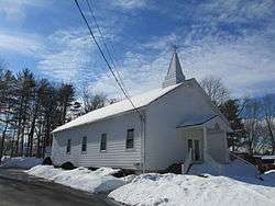
Grace Chapel Church of the Nazarene | |
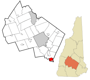 Location in Merrimack County and the state of New Hampshire | |
| Coordinates: 43°1′50″N 71°26′13″W / 43.03056°N 71.43694°WCoordinates: 43°1′50″N 71°26′13″W / 43.03056°N 71.43694°W | |
| Country | United States |
| State | New Hampshire |
| County | Merrimack |
| Town | Hooksett |
| Area | |
| • Total | 5.31 sq mi (13.75 km2) |
| • Land | 5.31 sq mi (13.74 km2) |
| • Water | 0.004 sq mi (0.01 km2) |
| Elevation | 443 ft (135 m) |
| Population (2010) | |
| • Total | 5,418 |
| • Density | 1,021/sq mi (394.1/km2) |
| Time zone | Eastern (EST) (UTC-5) |
| • Summer (DST) | EDT (UTC-4) |
| Area code(s) | 603 |
| FIPS code | 33-71220 |
| GNIS feature ID | 0870038 |
South Hooksett is a village[1] and census-designated place (CDP) within the town of Hooksett in Merrimack County, New Hampshire, United States. The population was 5,418 at the 2010 census.[2]
It is a suburban area adjacent to the city of Manchester, New Hampshire's largest city. South Hooksett includes suburban housing developments and large retail stores and plays an important part in the Greater Manchester area.
Geography
South Hooksett is located in the southern part of the town of Hooksett (and the southern part of Merrimack County) at 43°1′51″N 71°26′5″W / 43.03083°N 71.43472°W (43.030833, -71.434860).[3] It is bordered to the west and south by the city of Manchester in Hillsborough County, to the east by the town of Auburn in Rockingham County, and to the north by Depot Road, Martins Ferry Road, Benton Road, Londonderry Turnpike (New Hampshire Route 28 Bypass), Whitehall Road (New Hampshire Route 27), and Farmer Road. A portion of the town of Hooksett south of Smyth Road and north of the Manchester line is outside the CDP. Part of the campus of Southern New Hampshire University is within the CDP.[4]
According to the United States Census Bureau, the CDP has a total area of 5.3 square miles (13.8 km2), of which 0.004 square miles (0.01 km2), or 0.07%, is water.[2]
Demographics
As of the census of 2010, there were 5,418 people, 1,765 households, and 1,297 families residing in the CDP. The population density was 1,020.3 people per square mile (394.1/km²). There were 1,845 housing units at an average density of 347.5 per square mile (134.2/km²). The racial makeup of the CDP was 94.4% White, 1.2% African American, 0.3% Native American, 2.0% Asian, 0.1% Pacific Islander, 0.7% some other race, and 1.5% from two or more races. Hispanic or Latino of any race were 2.0% of the population.[5]
There were 1,765 households, out of which 36.7% had children under the age of 18 living with them, 60.6% were headed by married couples living together, 8.7% had a female householder with no husband present, and 26.5% were non-families. 18.0% of all households were made up of individuals, and 6.8% were someone living alone who was 65 years of age or older. The average household size was 2.69, and the average family size was 3.07.[5]
In the CDP the population was spread out with 21.7% under the age of 18, 17.6% from 18 to 24, 23.1% from 25 to 44, 27.3% from 45 to 64, and 10.4% who were 65 years of age or older. The median age was 36.2 years. For every 100 females there were 93.2 males. For every 100 females age 18 and over, there were 91.5 males.[5]
For the period 2009 through 2013, the estimated median annual income for a household in the CDP was $87,377, and the median income for a family was $105,769. Male full-time workers had a median income of $63,886 versus $44,522 for females. The per capita income for the CDP was $33,319.[6]
References
- ↑ http://www.nh.gov/nhes/elmi/htmlprofiles/hooksett.html
- 1 2 "Profile of General Geographic Identifiers: 2010 Census Summary File 1 (G001) - South Hooksett CDP, New Hampshire". U.S. Census Bureau American Factfinder. Retrieved November 12, 2015.
- ↑ "US Gazetteer files: 2010, 2000, and 1990". United States Census Bureau. 2011-02-12. Retrieved 2011-04-23.
- ↑ "TIGERweb". Geography Division, U.S. Census Bureau. Retrieved November 12, 2015.
- 1 2 3 "Profile of General Population and Housing Characteristics: 2010 Census Summary File 1 (DP-1) - South Hooksett CDP, New Hampshire". U.S. Census Bureau American Factfinder. Retrieved November 12, 2015.
- ↑ "Selected Economic Characteristics: 2009-2013 American Community Survey 5-Year Estimates (DP03) - South Hooksett CDP, New Hampshire". U.S. Census Bureau American Factfinder. Retrieved November 12, 2015.
Municipalities and communities of Merrimack County, New Hampshire, United States | ||
|---|---|---|
| Cities |  | |
| Towns | ||
| CDPs | ||
| Other unincorporated communities | ||
| Footnotes | ‡This populated place also has portions in an adjacent county or counties | |