West Hopkinton, New Hampshire
| West Hopkinton, New Hampshire | |
|---|---|
| Populated place | |
|
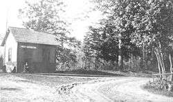
West Hopkinton Railroad Depot circa early 1900s | |
 West Hopkinton  West Hopkinton | |
| Coordinates: 43°11′31″N 71°44′53″W / 43.1920236°N 71.7481328°WCoordinates: 43°11′31″N 71°44′53″W / 43.1920236°N 71.7481328°W | |
| Country | United States |
| State | New Hampshire |
| County | Merrimack |
| Town | Hopkinton |
| Elevation | 370 ft (115 m) |
| Time zone | Eastern (EST) (UTC-5) |
| • Summer (DST) | EDT (UTC-4) |
| ZIP code | 03229 |
| Area code(s) | 603 |
| FIPS code | 33-82260 |
| GNIS feature ID | 0870776 |
West Hopkinton is a populated place[1] within the town of Hopkinton in Merrimack County, New Hampshire, United States. West Hopkinton is well known for its agricultural center, preservation of historical landmarks and recreational activities within the village.
History
West Hopkinton was once a thriving village with many businesses such as several mills including the Kingsbury & Davis Machine Company, a creamery, grocery store and a number of working farms. West Hopkinton had its own post office which opened on May 29, 1857; a small railroad depot on the original Contoocook River Railroad line, the Rowell's Covered Bridge and New Henniker Bridge.[2][3]
References
- ↑ New Hampshire Employment Security, , Hopkinton NH Community Profile
- ↑ Mala Duclos Tyler (2012). Hopkinton and Contoocook. Arcadia Publishing. ISBN 9780738591377.
- ↑ Lord, Charles Chase (1890). Life and times in Hopkinton, NH. Concord, N.H. Republican press association.
Municipalities and communities of Merrimack County, New Hampshire, United States | ||
|---|---|---|
| Cities |  | |
| Towns | ||
| CDPs | ||
| Other unincorporated communities | ||
| Footnotes | ‡This populated place also has portions in an adjacent county or counties | |
This article is issued from Wikipedia - version of the 11/28/2016. The text is available under the Creative Commons Attribution/Share Alike but additional terms may apply for the media files.