Bousseviller
Not to be confused with Buswiller.
| Bousseviller | ||
|---|---|---|
 | ||
| ||
 Bousseviller | ||
|
Location within Grand Est region  Bousseviller | ||
| Coordinates: 49°07′18″N 7°27′54″E / 49.1217°N 7.465°ECoordinates: 49°07′18″N 7°27′54″E / 49.1217°N 7.465°E | ||
| Country | France | |
| Region | Grand Est | |
| Department | Moselle | |
| Arrondissement | Sarreguemines | |
| Canton | Bitche | |
| Intercommunality | CC du Pays de Bitche | |
| Government | ||
| • Mayor (2008–2014) | Marie-Agnès Philippon | |
| Area1 | 4.01 km2 (1.55 sq mi) | |
| Population (2009)2 | 136 | |
| • Density | 34/km2 (88/sq mi) | |
| Time zone | CET (UTC+1) | |
| • Summer (DST) | CEST (UTC+2) | |
| INSEE/Postal code | 57103 / 57230 | |
| Elevation |
257–384 m (843–1,260 ft) (avg. 150 m or 490 ft) | |
|
1 French Land Register data, which excludes lakes, ponds, glaciers > 1 km² (0.386 sq mi or 247 acres) and river estuaries. 2 Population without double counting: residents of multiple communes (e.g., students and military personnel) only counted once. | ||

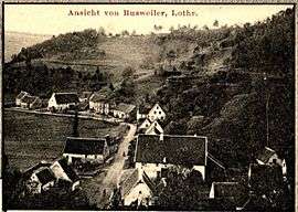
Bousseviller (German: Busweiler, Lorraine Franconian: Busswiller) is a commune in the Moselle department of the Grand Est administrative region in north-eastern France.
The village belongs to the Pays de Bitche and to the Northern Vosges Regional Nature Park.
Population
| Historical population | ||
|---|---|---|
| Year | Pop. | ±% |
| 1793 | 559 | — |
| 1800 | 119 | −78.7% |
| 1806 | 203 | +70.6% |
| 1821 | 230 | +13.3% |
| 1836 | 284 | +23.5% |
| 1841 | 306 | +7.7% |
| 1861 | 256 | −16.3% |
| 1866 | 250 | −2.3% |
| 1872 | 261 | +4.4% |
| 1876 | 241 | −7.7% |
| 1881 | 249 | +3.3% |
| 1886 | 223 | −10.4% |
| 1891 | 214 | −4.0% |
| 1896 | 221 | +3.3% |
| 1901 | 195 | −11.8% |
| 1906 | 229 | +17.4% |
| 1911 | 236 | +3.1% |
| 1921 | 232 | −1.7% |
| 1926 | 248 | +6.9% |
| 1931 | 240 | −3.2% |
| 1936 | 250 | +4.2% |
| 1946 | 135 | −46.0% |
| 1954 | 141 | +4.4% |
| 1962 | 151 | +7.1% |
| 1968 | 166 | +9.9% |
| 1975 | 178 | +7.2% |
| 1982 | 154 | −13.5% |
| 1990 | 145 | −5.8% |
| 1999 | 150 | +3.4% |
| 2006 | 136 | −9.3% |
| 2009 | 136 | +0.0% |
See also
| Wikimedia Commons has media related to Bousseviller. |
References
This article is issued from Wikipedia - version of the 11/17/2016. The text is available under the Creative Commons Attribution/Share Alike but additional terms may apply for the media files.