Siersthal
| Siersthal | ||
|---|---|---|
| ||
 Siersthal | ||
|
Location within Grand Est region  Siersthal | ||
| Coordinates: 49°02′39″N 7°20′57″E / 49.0442°N 7.3492°ECoordinates: 49°02′39″N 7°20′57″E / 49.0442°N 7.3492°E | ||
| Country | France | |
| Region | Grand Est | |
| Department | Moselle | |
| Arrondissement | Sarreguemines | |
| Canton | Bitche | |
| Intercommunality | CC du Pays de Bitche | |
| Government | ||
| • Mayor (2008–2014) | Daniel Zintz | |
| Area1 | 10.51 km2 (4.06 sq mi) | |
| Population (1999)2 | 694 | |
| • Density | 66/km2 (170/sq mi) | |
| Time zone | CET (UTC+1) | |
| • Summer (DST) | CEST (UTC+2) | |
| INSEE/Postal code | 57651 / 57410 | |
| Elevation |
258–403 m (846–1,322 ft) (avg. 215 m or 705 ft) | |
|
1 French Land Register data, which excludes lakes, ponds, glaciers > 1 km² (0.386 sq mi or 247 acres) and river estuaries. 2 Population without double counting: residents of multiple communes (e.g., students and military personnel) only counted once. | ||

Siersthal (Lorraine Franconian: Siirschel) is a commune in the Moselle department of the Grand Est administrative region in north-eastern France.
The village belongs to the Pays de Bitche and to the Northern Vosges Regional Nature Park. It is 10 kilometres (6.2 mi) away from the Franco-German border.
Geography
The area of Siersthal is 10.5 square kilometres (4.1 sq mi), population density is 63.1 inhabitants per square kilometre (163/sq mi).
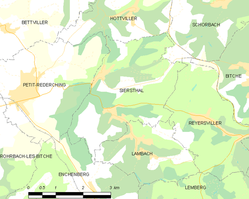
The map below shows the location of Siersthal with key infrastructure and adjacent municipalities.
Demographics
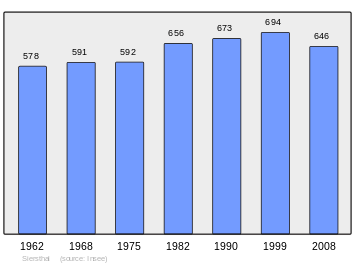
The figure below shows the development of the population from the INSEE.
See also
| Wikimedia Commons has media related to Siersthal. |
This article is issued from Wikipedia - version of the 11/17/2016. The text is available under the Creative Commons Attribution/Share Alike but additional terms may apply for the media files.