Sierck-les-Bains
| Sierck-les-Bains | ||
|---|---|---|
 | ||
| ||
 Sierck-les-Bains | ||
|
Location within Grand Est region  Sierck-les-Bains | ||
| Coordinates: 49°26′35″N 6°21′39″E / 49.4431°N 6.3608°ECoordinates: 49°26′35″N 6°21′39″E / 49.4431°N 6.3608°E | ||
| Country | France | |
| Region | Grand Est | |
| Department | Moselle | |
| Arrondissement | Thionville | |
| Canton | Bouzonville | |
| Intercommunality | Communauté de communes des Trois Frontières | |
| Government | ||
| • Mayor (2008–2014) | Laurent Steichen | |
| Area1 | 4.8 km2 (1.9 sq mi) | |
| Population (2006)2 | 1,730 | |
| • Density | 360/km2 (930/sq mi) | |
| Time zone | CET (UTC+1) | |
| • Summer (DST) | CEST (UTC+2) | |
| INSEE/Postal code | 57650 / 57480 | |
| Elevation | 145–337 m (476–1,106 ft) | |
|
1 French Land Register data, which excludes lakes, ponds, glaciers > 1 km² (0.386 sq mi or 247 acres) and river estuaries. 2 Population without double counting: residents of multiple communes (e.g., students and military personnel) only counted once. | ||

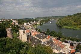
Sierck-les-Bains (German: Bad Sierck, Lorraine Franconian: Siirk/Siirck) is a commune in the Moselle department in Grand Est in north-eastern France.
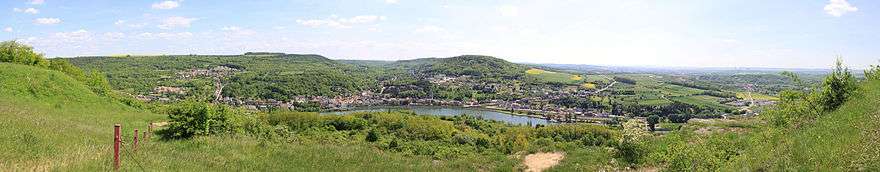
Panorama of Sierck les bains from the Stromberg 180°
Localities of the commune: Rudling, Kœnigsberg.
See also
| Wikimedia Commons has media related to Sierck-les-Bains. |
This article is issued from Wikipedia - version of the 11/17/2016. The text is available under the Creative Commons Attribution/Share Alike but additional terms may apply for the media files.