Fleury, Moselle
| Fleury | ||
|---|---|---|
|
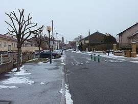
Gérard Mansion Street in Fleury | ||
| ||
 Fleury | ||
|
Location within Grand Est region  Fleury | ||
| Coordinates: 49°02′29″N 6°11′44″E / 49.0414°N 6.1956°ECoordinates: 49°02′29″N 6°11′44″E / 49.0414°N 6.1956°E | ||
| Country | France | |
| Region | Grand Est | |
| Department | Moselle | |
| Arrondissement | Metz | |
| Canton | Faulquemont | |
| Intercommunality | Communauté de communes du Vernois | |
| Government | ||
| • Mayor (2008–2014) | Jean-Paul Eckenfelder | |
| Area1 | 9.71 km2 (3.75 sq mi) | |
| Population (1999)2 | 1,132 | |
| • Density | 120/km2 (300/sq mi) | |
| Time zone | CET (UTC+1) | |
| • Summer (DST) | CEST (UTC+2) | |
| INSEE/Postal code | 57218 / 57420 | |
| Elevation |
170–237 m (558–778 ft) (avg. 350 m or 1,150 ft) | |
|
1 French Land Register data, which excludes lakes, ponds, glaciers > 1 km² (0.386 sq mi or 247 acres) and river estuaries. 2 Population without double counting: residents of multiple communes (e.g., students and military personnel) only counted once. | ||
.svg.png)
Fleury (German: Flöringen) is a commune in the Moselle department in Grand Est in north-eastern France.
Geography
The village is sited on a wooded plateau, high above the river Seille. The hilly topography gives rise to a range of microclimates and so agriculture surrounding the village is mixed, featuring arable crops and cattle rearing as well as vineyards.
History
Fleury was located within Saulnois, a region known as a source of salt over many centuries and under the control of the Three Bishoprics province.
Fleury was destroyed in 1352 by the army of the regent of Lorraine.
See also
| Wikimedia Commons has media related to Fleury (Moselle). |
This article is issued from Wikipedia - version of the 11/17/2016. The text is available under the Creative Commons Attribution/Share Alike but additional terms may apply for the media files.