Bristol Bay Borough, Alaska
| Bristol Bay Borough, Alaska | ||
|---|---|---|
| ||
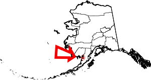 Location in the U.S. state of Alaska | ||
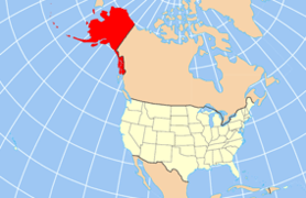 Alaska's location in the U.S. | ||
| Incorporated | October 2, 1962[1] | |
| Named for | Bristol Bay | |
| Seat | Naknek | |
| Largest community | Naknek | |
| Area | ||
| • Total | 888 sq mi (2,300 km2) | |
| • Land | 504 sq mi (1,305 km2) | |
| • Water | 384 sq mi (995 km2), 43.2% | |
| Population (est.) | ||
| • (2015) | 892 | |
| • Density | 2.0/sq mi (1/km²) | |
| Congressional district | At-large | |
| Time zone | Alaska: UTC-9/-8 | |
| Website |
www | |

Bristol Bay Borough is a borough of the U.S. state of Alaska on Bristol Bay or Iilgayaq Bay. As of the 2010 census the borough population was 997.[2] The borough seat is Naknek.[3] There are no incorporated settlements.
Incorporated in 1962, Bristol Bay was the first of Alaska's boroughs. It is also among the smallest, consisting of little more than the rectangle of land around Naknek on the coast and King Salmon (which, uniquely, serves as the borough seat for the neighboring Lake and Peninsula Borough) inland.
Geography
The borough has a total area of 888 square miles (2,300 km2), of which 504 square miles (1,310 km2) is land and 384 square miles (990 km2) (43.2%) is water.[4]
Adjacent boroughs and census areas
- Lake and Peninsula Borough, Alaska (east, north and south)
- Dillingham Census Area, Alaska (west)
National protected area
- Katmai National Park and Preserve (part)
- Katmai Wilderness (part)
Demographics
| Historical population | |||
|---|---|---|---|
| Census | Pop. | %± | |
| 1970 | 1,147 | — | |
| 1980 | 1,094 | −4.6% | |
| 1990 | 1,410 | 28.9% | |
| 2000 | 1,258 | −10.8% | |
| 2010 | 997 | −20.7% | |
| Est. 2015 | 892 | [5] | −10.5% |
| U.S. Decennial Census[6] 1900-1990[7] 1990-2000[8] 2010-2015[2] | |||
As of the census[9] of 2000, there were 1,258 people, 490 households, and 300 families residing in the borough. The population density was 2 people per square mile (1/km²). There were 979 housing units at an average density of 2 per square mile (1/km²). The racial makeup of the borough was 52.54% White, 0.56% Black or African American, 43.72% Native American, 0.24% Asian, 0.48% Pacific Islander, 0.08% from other races, and 2.38% from two or more races. 0.56% of the population were Hispanic or Latino of any race.
There were 490 households out of which 38.20% had children under the age of 18 living with them, 49.20% were married couples living together, 6.10% had a female householder with no husband present, and 38.60% were non-families. 31.20% of all households were made up of individuals and 2.90% had someone living alone who was 65 years of age or older. The average household size was 2.57 and the average family size was 3.33.
In the borough the population was spread out with 31.30% under the age of 18, 5.90% from 18 to 24, 34.80% from 25 to 44, 24.20% from 45 to 64, and 3.80% who were 65 years of age or older. The median age was 36 years. For every 100 females there were 119.50 males. For every 100 females age 18 and over, there were 125.60 males.
Communities
The Bristol Bay Borough has no incorporated cities. There are three census-designated places, corresponding to the borough's three population centers: King Salmon, Naknek and South Naknek. While these CDPs do not cover the borough's land mass, they contain 100 percent of the borough's population, per the 2010 Census.
See also
- List of airports in the Bristol Bay Borough
- National Register of Historic Places listings in Bristol Bay Borough, Alaska
References
- ↑ 1996 Alaska Municipal Officials Directory. Juneau: Alaska Municipal League/Alaska Department of Community and Regional Affairs. January 1996. p. 3.
- 1 2 "State & County QuickFacts". United States Census Bureau. Retrieved May 18, 2014.
- ↑ "Find a County". National Association of Counties. Archived from the original on 2011-05-31. Retrieved 2011-06-07.
- ↑ "US Gazetteer files: 2010, 2000, and 1990". United States Census Bureau. 2011-02-12. Retrieved 2011-04-23.
- ↑ "County Totals Dataset: Population, Population Change and Estimated Components of Population Change: April 1, 2010 to July 1, 2015". Retrieved July 2, 2016.
- ↑ "U.S. Decennial Census". United States Census Bureau. Archived from the original on May 11, 2015. Retrieved May 18, 2014.
- ↑ "Population of Counties by Decennial Census: 1900 to 1990". United States Census Bureau. Retrieved May 18, 2014.
- ↑ "Census 2000 PHC-T-4. Ranking Tables for Counties: 1990 and 2000" (PDF). United States Census Bureau. Retrieved May 18, 2014.
- ↑ "American FactFinder". United States Census Bureau. Archived from the original on 2013-09-11. Retrieved 2011-05-14.
External links
Municipalities and communities of Bristol Bay Borough, Alaska, United States | ||
|---|---|---|
| CDPs | | |
Juneau (capital) | ||
| Topics |
|  |
| Society |
| |
| Regions | ||
| Largest cities | ||
| Boroughs | ||
| Census Areas | ||
Coordinates: 58°45′N 156°50′W / 58.750°N 156.833°W