Kodiak Island Borough, Alaska
| Kodiak Island Borough, Alaska | |
|---|---|
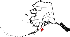 Location in the U.S. state of Alaska | |
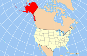 Alaska's location in the U.S. | |
| Incorporated | September 24, 1963[1][2] |
| Named for | Kodiak Island |
| Seat | Kodiak |
| Largest city | Kodiak |
| Area | |
| • Total | 12,022 sq mi (31,137 km2) |
| • Land | 6,550 sq mi (16,964 km2) |
| • Water | 5,472 sq mi (14,172 km2), 45.5% |
| Population (est.) | |
| • (2015) | 13,889 |
| • Density | 2.1/sq mi (1/km²) |
| Congressional district | At-large |
| Time zone | Alaska: UTC-9/-8 |
| Website |
www |
Kodiak Island Borough is a borough in the U.S. state of Alaska. At the 2010 census, the population was 13,592.[3] The borough seat is Kodiak.[4]
Geography
The borough has a total area of 12,022 square miles (31,140 km2), of which 6,550 square miles (17,000 km2) is land and 5,472 square miles (14,170 km2) (45.5%) is water.[5] Most of the land area belongs to Kodiak Island, but a thin strip of coastal area on the western part of the Alaska Peninsula and other nearby islands (Afognak Island, Shuyak Island, Marmot Island, Raspberry Island, Little Raspberry Island, Whale Island, Spruce Island, Woody Island, Uganik Island, Sitkalidak Island, Tugidak Island, Sitkinak Island, Chirikof Island, and the Semidi Islands) are also in the borough. The waterway between the island and mainland is known as the Shelikof Strait. South of the island are the open waters of the Pacific Ocean, so the site is considered good for launching certain types of satellites. The Kodiak Launch Complex is ideal for putting satellites in Molniya and polar orbits.
Adjacent boroughs
- Kenai Peninsula Borough, Alaska - north
- Lake and Peninsula Borough, Alaska - northwest
National protected areas
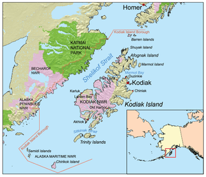
- Alaska Maritime National Wildlife Refuge (parts of Alaska Peninsula and Gulf of Alaska units)
- Barren Islands
- Semidi Wilderness
- Trinity Islands
- Alaska Peninsula National Wildlife Refuge (part)
- Becharof National Wildlife Refuge (part)
- Becharof Wilderness (part)
- Chugach National Forest (part)
- Katmai National Park and Preserve (part)
- Katmai Wilderness (part)
- Kodiak National Wildlife Refuge
Demographics
| Historical population | |||
|---|---|---|---|
| Census | Pop. | %± | |
| 1960 | 7,174 | — | |
| 1970 | 9,409 | 31.2% | |
| 1980 | 9,939 | 5.6% | |
| 1990 | 13,309 | 33.9% | |
| 2000 | 13,913 | 4.5% | |
| 2010 | 13,592 | −2.3% | |
| Est. 2015 | 13,889 | [6] | 2.2% |
| U.S. Decennial Census[7] 1790-1960[8] 1900-1990[9] 1990-2000[10] 2010-2015[3] | |||
As of the census[11] of 2000, there were 13,913 people, 4,424 households, and 3,256 families residing in the borough. The population density was 2 people per square mile (1/km²). There were 5,159 housing units at an average density of 1 per square mile (0/km²). The racial makeup of the borough was 59.69% White, 0.96% Black or African American, 14.58% Native American, 16.04% Asian, 0.79% Pacific Islander, 2.78% from other races, and 5.16% from two or more races. 6.10% of the population were Hispanic or Latino of any race. 13.10% reported speaking Tagalog at home, a language of the Philippines, while 5.28% speak Spanish.[12]
There were 4,424 households out of which 45.90% had children under the age of 18 living with them, 59.70% were married couples living together, 8.80% had a female householder with no husband present, and 26.40% were non-families. 19.90% of all households were made up of individuals and 3.70% had someone living alone who was 65 years of age or older. The average household size was 3.07 and the average family size was 3.52.
In the borough the population was spread out with 32.40% under the age of 18, 8.30% from 18 to 24, 34.00% from 25 to 44, 20.40% from 45 to 64, and 4.80% who were 65 years of age or older. The median age was 32 years. For every 100 females there were 112.40 males. For every 100 females age 18 and over, there were 117.40 males.
Communities
| Wikimedia Commons has media related to Kodiak Island Borough, Alaska. |
See also
References
- ↑ "Government". Kodiak Island, AK - Official Website. Kodiak Island Borough. Retrieved 2012-05-04.
- ↑ 1996 Alaska Municipal Officials Directory. Juneau: Alaska Municipal League/Alaska Department of Community and Regional Affairs. January 1996. p. 10.
- 1 2 "State & County QuickFacts". United States Census Bureau. Retrieved May 18, 2014.
- ↑ "Find a County". National Association of Counties. Retrieved 2011-06-07.
- ↑ "US Gazetteer files: 2010, 2000, and 1990". United States Census Bureau. 2011-02-12. Retrieved 2011-04-23.
- ↑ "County Totals Dataset: Population, Population Change and Estimated Components of Population Change: April 1, 2010 to July 1, 2015". Retrieved July 2, 2016.
- ↑ "U.S. Decennial Census". United States Census Bureau. Retrieved May 18, 2014.
- ↑ "Historical Census Browser". University of Virginia Library. Retrieved May 18, 2014.
- ↑ "Population of Counties by Decennial Census: 1900 to 1990". United States Census Bureau. Retrieved May 18, 2014.
- ↑ "Census 2000 PHC-T-4. Ranking Tables for Counties: 1990 and 2000" (PDF). United States Census Bureau. Retrieved May 18, 2014.
- ↑ "American FactFinder". United States Census Bureau. Retrieved 2011-05-14.
- ↑ , Modern Language Association
External links
 |
Lake and Peninsula Borough | Kenai Peninsula Borough | | |
| |
Gulf of Alaska | |||
| ||||
| | ||||
Municipalities and communities of Kodiak Island Borough, Alaska, United States | ||
|---|---|---|
| Cities | | |
| CDPs | ||
| Ghost towns | ||
Juneau (capital) | ||
| Topics |
|  |
| Society |
| |
| Regions | ||
| Largest cities | ||
| Boroughs | ||
| Census Areas | ||
Coordinates: 57°43′N 153°47′W / 57.71°N 153.78°W