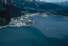
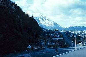
Seward, Alaska
| Seward, Alaska | ||
|---|---|---|
| City | ||
| ||
| Motto: "Alaska Starts Here" | ||
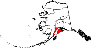
 Seward, Alaska Location in Alaska | ||
| Coordinates: 60°07′28″N 149°26′00″W / 60.12444°N 149.43333°WCoordinates: 60°07′28″N 149°26′00″W / 60.12444°N 149.43333°W | ||
| Country | United States | |
| State | Alaska | |
| Borough | Kenai Peninsula | |
| Established | 1903 | |
| Incorporated | June 1, 1912[1] | |
| Government | ||
| • Mayor | Jean Bardarson[2] | |
| • State senator | Peter Micciche (R) | |
| • State rep. | Mike Chenault (R) | |
| Area | ||
| • Total | 21.5 sq mi (55.8 km2) | |
| • Land | 14.4 sq mi (37.4 km2) | |
| • Water | 7.1 sq mi (18.4 km2) | |
| Elevation | 0 ft (0 m) | |
| Population (2010) | ||
| • Total | 2,693 | |
| • Density | 125.3/sq mi (75.7/km2) | |
| Time zone | Alaska (UTC-9) | |
| • Summer (DST) | Alaska (UTC-8) | |
| ZIP code | 99664 | |
| Area code | 907 | |
| FIPS code | 02-68560 | |
| GNIS feature ID | 1414598 | |
| Website | City of Seward Website | |
| Source of coordinates [3] | ||

Seward (Alutiiq: Qutalleq) is a city in Kenai Peninsula Borough in the U.S. state of Alaska. According to 2014 Census Bureau estimates, the population of the city is 2,528. It was named after William H. Seward, United States Secretary of State under Abraham Lincoln and Andrew Johnson. In 1867, he fought for the U.S. purchase of Alaska which he finally negotiated to acquire from Russia.
Mile 0 of the historic Iditarod Trail is at Seward. In the early 1900s the trail was blazed in order to transport people and goods to and from the port of Seward to interior Alaska.
History
In 1793 Alexander Baranov of the Shelikhov-Golikov company (precursor of the Russian-American Company) established a fur trade post on Resurrection Bay where Seward is today, and had a three-masted vessel, the Phoenix, built at the post by James Shields, an English shipwright in Russian service.[4]
The 1939 Slattery Report on Alaskan development identified the region as one of the areas where new settlements would be established through Jewish immigration. This plan was never implemented.
A large portion of Seward was damaged by shaking and a local tsunami during the 1964 Alaska earthquake.[5]
Geography
According to the United States Census Bureau, the city has a total area of 21.5 square miles (56 km2), of which 14.4 square miles (37 km2) is land and 7.1 square miles (18 km2) (32.93%) is water.
Adjoining communities include Bear Creek and Lowell Point.
Climate
Seward has, depending on the isotherm, a subpolar oceanic climate (Köppen Cfc) or a subarctic climate (Köppen Dfc), and lies just within the subpolar/subarctic zone,[6] with moderate temperatures for Alaska and, due to its location along the Gulf of Alaska coast, high levels of precipitation.
| Climate data for Seward Airport (1981−2010 normals) | |||||||||||||
|---|---|---|---|---|---|---|---|---|---|---|---|---|---|
| Month | Jan | Feb | Mar | Apr | May | Jun | Jul | Aug | Sep | Oct | Nov | Dec | Year |
| Average high °F (°C) | 31.8 (−0.1) |
33.4 (0.8) |
37.8 (3.2) |
44.8 (7.1) |
53.0 (11.7) |
58.3 (14.6) |
61.3 (16.3) |
61.5 (16.4) |
55.2 (12.9) |
44.5 (6.9) |
35.4 (1.9) |
33.6 (0.9) |
45.9 (7.7) |
| Daily mean °F (°C) | 27.1 (−2.7) |
28.3 (−2.1) |
32.1 (0.1) |
38.7 (3.7) |
46.4 (8) |
52.2 (11.2) |
56.0 (13.3) |
55.7 (13.2) |
49.5 (9.7) |
39.6 (4.2) |
30.9 (−0.6) |
28.9 (−1.7) |
40.6 (4.8) |
| Average low °F (°C) | 22.3 (−5.4) |
23.2 (−4.9) |
26.4 (−3.1) |
32.5 (0.3) |
39.9 (4.4) |
46.1 (7.8) |
50.7 (10.4) |
50.0 (10) |
43.8 (6.6) |
34.7 (1.5) |
26.4 (−3.1) |
24.2 (−4.3) |
35.0 (1.7) |
| Average precipitation inches (mm) | 8.07 (205) |
6.05 (153.7) |
4.42 (112.3) |
4.52 (114.8) |
3.37 (85.6) |
2.42 (61.5) |
2.80 (71.1) |
5.61 (142.5) |
9.86 (250.4) |
9.35 (237.5) |
7.31 (185.7) |
9.54 (242.3) |
73.32 (1,862.4) |
| Average snowfall inches (cm) | 12.9 (32.8) |
12.6 (32) |
10.5 (26.7) |
3.7 (9.4) |
.3 (0.8) |
0 (0) |
0 (0) |
0 (0) |
0 (0) |
.5 (1.3) |
8.2 (20.8) |
15.7 (39.9) |
64.4 (163.7) |
| Average precipitation days (≥ 0.01 in) | 15.1 | 13.7 | 13.1 | 13.7 | 13.5 | 11.6 | 12.5 | 14.1 | 16.9 | 16.5 | 14.3 | 16.6 | 171.6 |
| Average snowy days (≥ 0.1 in) | 5.8 | 5.0 | 4.7 | 2.2 | .1 | 0 | 0 | 0 | 0 | .8 | 3.9 | 6.7 | 29.2 |
| Source: NOAA[7] | |||||||||||||
Economy
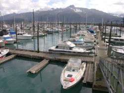
- According to a 2011 National Marine Fisheries Service report, Seward is the ninth most lucrative fisheries port in the United States based on the monetary value of fish taken from the port. In 2010, 69.2 million dollars worth of fish and shellfish passed through Seward, this was up significantly from 2009 when the port brought in 33.1 million dollars.[8]
- Another major industry in Seward is tourism.
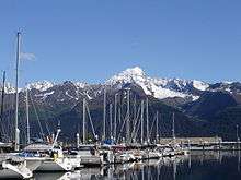
- Seward is also an Alaska Railroad terminus which has a maintained dock for cruise vessels and it controls a shipping terminal for coal from Usibelli. The Railroad and Aurora Energy Services employ dozens of people in the local area.
- Seward also has a minor military installation and is the homeport of the USCGC Mustang.
Demographics
| Historical population | |||
|---|---|---|---|
| Census | Pop. | %± | |
| 1910 | 534 | — | |
| 1920 | 652 | 22.1% | |
| 1930 | 835 | 28.1% | |
| 1940 | 949 | 13.7% | |
| 1950 | 2,114 | 122.8% | |
| 1960 | 1,891 | −10.5% | |
| 1970 | 1,587 | −16.1% | |
| 1980 | 1,843 | 16.1% | |
| 1990 | 2,699 | 46.4% | |
| 2000 | 2,830 | 4.9% | |
| 2010 | 2,693 | −4.8% | |
| Est. 2015 | 2,790 | [9] | 3.6% |
As of the census[11] of 2000, there were 2,830 people, 917 households, and 555 families residing in the city. The population density was 196.0 people per square mile (75.7/km²). There were 1,058 housing units at an average density of 73.3 per square mile (28.3/km²). The racial makeup of the city was 72.12% White, 2.44% Black or African American, 16.68% Native American, 1.84% Asian, 0.18% Pacific Islander, 0.88% from other races, and 5.87% from two or more races. 2.40% of the population were Hispanic or Latino of any race.
There were 917 households out of which 35.7% had children under the age of 18 living with them, 44.6% were married couples living together, 12.1% had a female householder with no husband present, and 39.4% were non-families. 30.8% of all households were made up of individuals and 7.1% had someone living alone who was 65 years of age or older. The average household size was 2.40 and the average family size was 3.04.
In the city the age distribution of the population shows 21.9% under the age of 18, 9.0% from 18 to 24, 35.9% from 25 to 44, 25.7% from 45 to 64, and 7.5% who were 65 years of age or older. The median age was 37 years. For every 100 females there were 150.2 males. For every 100 females age 18 and over, there were 166.6 males.
The median income for a household in the city was $44,306, and the median income for a family was $54,904. Males had a median income of $36,900 versus $30,508 for females. The per capita income for the city was $20,360. About 8.3% of families and 10.6% of the population were below the poverty line, including 12.7% of those under age 18 and 7.9% of those age 65 or over.
Government and infrastructure
The Alaska Department of Corrections operates the Spring Creek Correctional Center in Seward.[12][13]
The Alaska Department of Labor and Workforce Development operates AVTEC, Alaska's Institute of Technology in Seward.
The United States Postal Service operates the Seward Post Office.[14]
Transportation
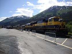
Seward is unusual among most small Alaskan communities in that it has road access in the Seward Highway from Seward to Anchorage, a National Scenic Byway and All-American Road, which also brings it bus service. Seward is also the southern terminus of the Alaska Railroad. This keeps the port busy with freight coming on and off the trains, but also makes Seward a primary end point for north-bound cruise ships. Cruise ship passengers disembark and often take the train or bus farther north to Anchorage, Denali, or other Alaskan attractions.
Seward is a very bike friendly community. A paved bike path runs from the downtown business district along the waterfront, through the harbor and along the highway to mile 4.5. Bikes are available for rent and there are guided bike tours of the area.
Alaska Marine Highway (ferry) service was discontinued at the end of the 2005. State ferry connections are now available in Whittier (90 miles North) or Homer (150 miles by highway).
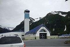
Seward Airport (PAWD/SWD) is home to (general aviation) services and flight-seeing operators. Scheduled commercial service is available at Kenai Municipal Airport in Kenai and Ted Stevens Anchorage International Airport, both about 100 miles (160 km) away. Bus connections are also available.
International sister cities

 Obihiro, Japan - (1968)
Notable people
- In 1927, thirteen-year-old Seward resident and Native Alaskan, Benny Benson, won a territory-wide American Legion contest to design a flag for Alaska. Born in Chignik in 1913, he was three when his mother died of pneumonia. Soon after her death the family's house burned and his Swedish fisherman father sent Benny and his brother to the Jesse Lee Home in Seward. Winning the contest changed Benny's life. The prize for designing the flag included a $1000 scholarship which he used to become an airplane mechanic. He married, raised a family, and died of a heart attack in 1972 at the age of 58. His design became the territorial flag and eventually the state flag. He is memorialized in Seward by the Benny Benson Memorial Park.[15]
- Chad Bentz, Major League Baseball Player
- Harry Kawabe, Japanese-American businessman sent to internment camp during World War II
Attractions and points of interest
- Mount Marathon and its famous Mount Marathon Race
- Kenai Fjords National Park with its easily accessible Exit Glacier
- Alaska SeaLife Center
- Seward Silver Salmon Derby
- Seward Polar Bear Jump-Off
- Seward Spring Break Up Festival
- Seward Music and Arts Festival, every year in September
- Balto Film Fest, last weekend of July
- The ruins of the Jesse Lee Home for Children
Education
The Kenai Peninsula Borough School District operates schools in Seward. Seward Elementary School, Seward Middle School, and Seward High School serve Seward.[16]
References
- ↑ 1996 Alaska Municipal Officials Directory. Juneau: Alaska Municipal League/Alaska Department of Community and Regional Affairs. January 1996. p. 138.
- ↑ 2015 Alaska Municipal Officials Directory. Juneau: Alaska Municipal League. 2015. p. 144.
- ↑ "US Gazetteer files: 2010, 2000, and 1990". United States Census Bureau. 2011-02-12. Retrieved 2011-04-23.
- ↑ Haycox, Stephen W. (2002). Alaska: An American Colony. University of Washington Press. p. 82. ISBN 978-0-295-98249-6.
- ↑ "Effects of the 1964 Tsunami on Seward Alaska". www.usc.edu. Retrieved 2016-05-28.
- ↑ Kottek, M.; Grieser, J. R.; Beck, C.; Rudolf, B.; Rubel, F. (2006). "World Map of the Köppen-Geiger climate classification updated" (PDF). Meteorol. Z. 15 (3): 259–263. doi:10.1127/0941-2948/2006/0130.
- ↑ "Station Name: AK SEWARD AP". National Oceanic and Atmospheric Administration. Retrieved 2013-07-05.
- ↑ 2011 NOAA National Marine Fisheries Report: http://www.nmfs.noaa.gov/mediacenter/docs/2011/sep/fus_sept2011.pdf
- ↑ "Annual Estimates of the Resident Population for Incorporated Places: April 1, 2010 to July 1, 2015". Retrieved July 2, 2016.
- ↑ "Census of Population and Housing". Census.gov. Retrieved June 4, 2015.
- ↑ "American FactFinder". United States Census Bureau. Retrieved 2008-01-31.
- ↑ "City of Seward 2020 Comprehensive Plan Volume II." City of Seward. 94/97. Retrieved on August 15, 2010.
- ↑ "Spring Creek Correctional Center." Alaska Department of Corrections. Retrieved on August 15, 2010.
- ↑ "Post Office Location - SEWARD." United States Postal Service. Retrieved on August 15, 2010.
- ↑ University of Alaska. "Alaska State Flag, and Song, Intertwined Around Benny Benson." UA Informational Highlights. University of Alaska, Statewide Office of Public Affairs. Retrieved on 2007-04-29.
- ↑ "Attendance Area Boundaries." Kenai Peninsula Borough School District. Retrieved on September 27, 2010.
External links
| Wikimedia Commons has media related to Seward, Alaska. |
-
 Seward travel guide from Wikivoyage
 - City of Seward in Alaska
- Seward Chamber of Commerce and Conference & Visitors Bureau
- The Seward Phoenix LOG, weekly newspaper serving the Eastern Kenai Peninsula since 1966
- SewardCityNews.com Seward's citizen journalism site
- Seward, Alaska at DMOZ