Broualan
| Broualan Broualan | ||
|---|---|---|
|
Town hall | ||
| ||
 Broualan | ||
|
Location within Brittany region  Broualan | ||
| Coordinates: 48°28′28″N 1°38′56″W / 48.4744°N 1.6489°WCoordinates: 48°28′28″N 1°38′56″W / 48.4744°N 1.6489°W | ||
| Country | France | |
| Region | Brittany | |
| Department | Ille-et-Vilaine | |
| Arrondissement | Saint-Malo | |
| Canton | Pleine-Fougères | |
| Intercommunality | Baie du Mont-Saint-Michel | |
| Government | ||
| • Mayor (2014–2020) | Didier Gouablin | |
| Area1 | 12.76 km2 (4.93 sq mi) | |
| Population (2008)2 | 314 | |
| • Density | 25/km2 (64/sq mi) | |
| Time zone | CET (UTC+1) | |
| • Summer (DST) | CEST (UTC+2) | |
| INSEE/Postal code | 35044 / 35120 | |
| Elevation | 60–116 m (197–381 ft) | |
|
1 French Land Register data, which excludes lakes, ponds, glaciers > 1 km² (0.386 sq mi or 247 acres) and river estuaries. 2 Population without double counting: residents of multiple communes (e.g., students and military personnel) only counted once. | ||
_Mairie.jpg)

Broualan (Breton: Broualan) is a commune in the Ille-et-Vilaine department in Brittany in northwestern France.
Population
Inhabitants of Broualan are called Broualanais in French.
| Historical population | ||
|---|---|---|
| Year | Pop. | ±% |
| 1962 | 299 | — |
| 1968 | 372 | +24.4% |
| 1975 | 299 | −19.6% |
| 1982 | 268 | −10.4% |
| 1990 | 279 | +4.1% |
| 1999 | 290 | +3.9% |
| 2008 | 314 | +8.3% |
Gallery
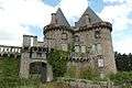 Château de Landal
_%C3%89glise_7.jpg) Notre-Dame-de-Toutes-Joies church
Notre-Dame-de-Toutes-Joies church
See also
References
External links
| Wikimedia Commons has media related to Broualan. |
This article is issued from Wikipedia - version of the 9/17/2015. The text is available under the Creative Commons Attribution/Share Alike but additional terms may apply for the media files.