Aubigné, Ille-et-Vilaine
| Aubigné Elvinieg | ||
|---|---|---|
|
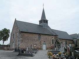
Église Notre-Dame d’Aubigné | ||
| ||
 Aubigné | ||
|
Location within Brittany region  Aubigné | ||
| Coordinates: 48°17′43″N 1°38′01″W / 48.2953°N 1.6336°WCoordinates: 48°17′43″N 1°38′01″W / 48.2953°N 1.6336°W | ||
| Country | France | |
| Region | Brittany | |
| Department | Ille-et-Vilaine | |
| Arrondissement | Rennes | |
| Canton | Saint-Aubin-d'Aubigné | |
| Intercommunality | Pays d'Aubigné | |
| Government | ||
| • Mayor (2014–2020) | Youri Moysan | |
| Area1 | 2.20 km2 (0.85 sq mi) | |
| Population (2009)2 | 405 | |
| • Density | 180/km2 (480/sq mi) | |
| Time zone | CET (UTC+1) | |
| • Summer (DST) | CEST (UTC+2) | |
| INSEE/Postal code | 35007 / 35250 | |
| Elevation | 52–87 m (171–285 ft) | |
|
1 French Land Register data, which excludes lakes, ponds, glaciers > 1 km² (0.386 sq mi or 247 acres) and river estuaries. 2 Population without double counting: residents of multiple communes (e.g., students and military personnel) only counted once. | ||
.svg.png)
Aubigné (Breton: Elvinieg, Gallo: Aubeinyae) is a commune located in the Ille-et-Vilaine department in Brittany in northwestern France.
Population
| Historical population | ||
|---|---|---|
| Year | Pop. | ±% |
| 1962 | 136 | — |
| 1968 | 161 | +18.4% |
| 1975 | 157 | −2.5% |
| 1982 | 235 | +49.7% |
| 1990 | 237 | +0.9% |
| 1999 | 240 | +1.3% |
| 2006 | 335 | +39.6% |
| 2009 | 405 | +20.9% |
Inhabitants of Aubigné are called Aubinois in French.
See also
References
- Mayors of Ille-et-Vilaine Association (French);
External links
| Wikimedia Commons has media related to Aubigné (Ille-et-Vilaine). |
This article is issued from Wikipedia - version of the 10/21/2016. The text is available under the Creative Commons Attribution/Share Alike but additional terms may apply for the media files.