Brownbranch, Missouri
| Brownbranch, Missouri | |
|---|---|
| Community | |
 Brownbranch, Missouri Location of Brownbranch, Missouri | |
| Coordinates: 36°47′41″N 92°49′52″W / 36.79472°N 92.83111°WCoordinates: 36°47′41″N 92°49′52″W / 36.79472°N 92.83111°W[1] | |
| Country | U. S. A. |
| State | Missouri |
| County | Taney County |
| Elevation[1] | 270 m (890 ft) |
| Time zone | CST (UTC-6) |
| • Summer (DST) | CDT (UTC-5) |
Brownbranch is an unincorporated community in northeastern Taney County, Missouri, United States. It is located on Beaver Creek at the intersection of Route 76 and Missouri Supplemental Route W about 23 miles (37 km) northeast of Forsyth. Bradleyville lies about 5.7 miles (9.2 km) to the west on Route 76 and McClurg lies about 3.5 miles (5.6 km) to the east on Route W.[1][2]
Brownbranch was the center of attention in the early 1900s. Included in the town was a school located where the current Caney General Baptist Church stands. Located across the road and on Beaver Creek included an old Mill where local farmers could come to have their corn ground. The town now only houses the church, a canoe rental, and a bed and breakfast facility.
Brownbranch had a post office from 1875 to 1962 (known as Brown Branch for the first 20 years).[3] Etycl and Susie Combs ran the old general store at Brownbranch for many years. Eulah Siler was the Postmaster at the Post Office in the general store for thirty years around 1934 - 1964.
Brownbranch is only a few miles away from the Mark Twain National Forest. The glade top trail is recognized and known throughout Missouri and includes a camping area as well as a covered picnic area with a scenic view. The chamber of commerce in nearby Ava utilizes the trail each fall with a festival which includes a chicken BBQ and other activities.
The community is part of the Branson, Missouri Micropolitan Statistical Area.
References
Municipalities and communities of Taney County, Missouri, United States | ||
|---|---|---|
| Cities | 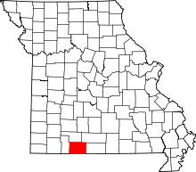 | |
| Villages | ||
| Townships |
| |
| CDP | ||
| Other unincorporated communities | ||
| Footnotes | ‡This populated place also has portions in an adjacent county or counties | |