Ava, Missouri
| Ava, Missouri | |
|---|---|
| City | |
|
Douglas County court house on the southeast corner of the Ava square | |
 Location of Ava, Missouri | |
| Coordinates: 36°57′23″N 92°39′47″W / 36.95639°N 92.66306°WCoordinates: 36°57′23″N 92°39′47″W / 36.95639°N 92.66306°W | |
| Country |
|
| State |
|
| County | Douglas |
| Government | |
| • Mayor | Eddie Maggard[1] |
| Area[2] | |
| • Total | 3.30 sq mi (8.55 km2) |
| • Land | 3.30 sq mi (8.55 km2) |
| • Water | 0 sq mi (0 km2) |
| Elevation | 1,283 ft (391 m) |
| Population (2010)[3] | |
| • Total | 2,993 |
| • Estimate (2012[4]) | 2,974 |
| • Density | 907.0/sq mi (350.2/km2) |
| Time zone | Central (CST) (UTC-6) |
| • Summer (DST) | CDT (UTC-5) |
| ZIP code | 65608 |
| Area code(s) | 417 |
| FIPS code | 29-02674[5] |
| GNIS feature ID | 0735491[6] |
| Website | avamissouri.org |

Ava is the only incorporated city in Douglas County, Missouri, United States. The population was 2,993 at the 2010 census. Ava is the county seat of Douglas County.[7] The city was founded in 1871. It was renamed Ava in 1881, the town's original name having been "Militia Springs."
Geography
Ava is located in the southern portion of the Missouri Ozarks within the southern escarpment of the Salem Plateau. The lakes of the White River basin of northern Arkansas and southern Missouri lie to the south. The town is at the intersection of Missouri highways 5, 14 and 76. Mansfield is 13 miles to the north and Gainesville is about 30 miles south. Elevation of the town varies from 1,150 to 1,400 feet (350 to 430 m).[8]
According to the United States Census Bureau, the city has a total area of 3.30 square miles (8.55 km2), all of it land.[2]
Ava is served by the AM-FM station pair of KKOZ and KKOZ-FM.
History
The area was settled during the 1830s and Douglas County was incorporated in 1857 with Vera Cruz as county seat. In 1864[9] the town of Militia Springs was founded and became the new county seat in 1870. The town was platted in 1871 and renamed Ava in 1881 although not incorporated until 1908.[10] Militia Springs was the location of an encampment of Union soldiers or Missouri Militia during the American Civil War.[11]
During and following the Civil War a dispute was ongoing regarding the county seat between Vera Cruz to the east and Arno to the west. In 1871 the citizens of Militia Springs built a court house building and moved the records there as a compromise. However, the building was burned and then rebuilt of hand hewn timbers rather than logs and re-opened in January 1873. The court house was burned again in 1886 and replaced in 1888.[12] The current court house on the southeast corner of the town square was constructed in 1937.[12]

In 1910 the Kansas City, Ozark and Southern Railroad was extended from Mansfield south to Ava to service the growing agricultural and lumbering industries of Douglas County. The railroad was in operation until 1935.[13]

A city park, Militia Springs Park, was established in 2004 along Prairie Creek on NE 3rd Street. The location is the approximate site of the Civil War era military encampment. It has a play area and pavilion.[14]
The Missouri Fox Trotter association was organized in Ava in 1948 and the annual shows are held at the associations property just north of Ava.[15][16]
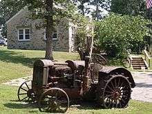
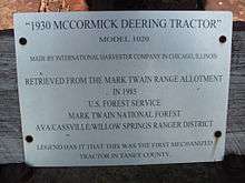
The Ava Ranger Station Historic District is listed in the National Register of Historic Places.
Demographics
| Historical population | |||
|---|---|---|---|
| Census | Pop. | %± | |
| 1880 | 134 | — | |
| 1890 | 221 | 64.9% | |
| 1910 | 713 | — | |
| 1920 | 845 | 18.5% | |
| 1930 | 1,041 | 23.2% | |
| 1940 | 1,393 | 33.8% | |
| 1950 | 1,611 | 15.6% | |
| 1960 | 1,581 | −1.9% | |
| 1970 | 2,504 | 58.4% | |
| 1980 | 2,761 | 10.3% | |
| 1990 | 2,938 | 6.4% | |
| 2000 | 3,021 | 2.8% | |
| 2010 | 2,993 | −0.9% | |
| Est. 2015 | 2,934 | [17] | −2.0% |
| U.S. Decennial Census | |||
2010 census
As of the census[3] of 2010, there were 2,993 people, 1,296 households, and 753 families residing in the city. The population density was 907.0 inhabitants per square mile (350.2/km2). There were 1,494 housing units at an average density of 452.7 per square mile (174.8/km2). The racial makeup of the city was 97.6% White, 0.1% African American, 0.5% Native American, 0.2% Asian, 0.2% from other races, and 1.4% from two or more races. Hispanic or Latino of any race were 1.0% of the population.
There were 1,296 households of which 28.4% had children under the age of 18 living with them, 38.1% were married couples living together, 15.4% had a female householder with no husband present, 4.6% had a male householder with no wife present, and 41.9% were non-families. 35.9% of all households were made up of individuals and 20.2% had someone living alone who was 65 years of age or older. The average household size was 2.22 and the average family size was 2.86.
The median age in the city was 40.8 years. 22.8% of residents were under the age of 18; 9.4% were between the ages of 18 and 24; 22.2% were from 25 to 44; 22.6% were from 45 to 64; and 22.9% were 65 years of age or older. The gender makeup of the city was 44.4% male and 55.6% female.
2000 census
As of the census[5] of 2000, there were 3,021 people, 1,350 households, and 764 families residing in the city. The population density was 973.0 people per square mile (376.3/km²). There were 1,493 housing units at an average density of 480.9 per square mile (186.0/km²). The racial makeup of the city was 96.79% White, 0.13% African American, 0.66% Native American, 0.43% Asian, 0.03% Pacific Islander, 0.26% from other races, and 1.69% from two or more races. Hispanic or Latino of any race were 1.36% of the population.
There were 1,350 households out of which 27.3% had children under the age of 18 living with them, 43.0% were married couples living together, 10.5% had a female householder with no husband present, and 43.4% were non-families. 39.3% of all households were made up of individuals and 23.3% had someone living alone who was 65 years of age or older. The average household size was 2.21 and the average family size was 2.96.
In the city the population was spread out with 25.4% under the age of 18, 8.3% from 18 to 24, 24.0% from 25 to 44, 19.3% from 45 to 64, and 23.0% who were 65 years of age or older. The median age was 38 years. For every 100 females there were 79.2 males. For every 100 females age 18 and over, there were 73.1 males.
The median income for a household in the city was $22,331, and the median income for a family was $28,228. Males had a median income of $25,865 versus $16,324 for females. The per capita income for the city was $13,307. About 16.0% of families and 21.7% of the population were below the poverty line, including 27.3% of those under age 18 and 25.8% of those age 65 or over.
References
- ↑ April 2011 City News - City of Ava Missouri Archived April 25, 2012, at the Wayback Machine.
- 1 2 "US Gazetteer files 2010". United States Census Bureau. Archived from the original on 2012-01-24. Retrieved 2012-07-08.
- 1 2 "American FactFinder". United States Census Bureau. Retrieved 2012-07-08.
- ↑ "Population Estimates". United States Census Bureau. Archived from the original on 2013-06-17. Retrieved 2013-05-30.
- 1 2 "American FactFinder". United States Census Bureau. Archived from the original on 2013-09-11. Retrieved 2008-01-31.
- ↑ "US Board on Geographic Names". United States Geological Survey. 2007-10-25. Retrieved 2008-01-31.
- ↑ "Find a County". National Association of Counties. Archived from the original on 2011-05-31. Retrieved 2011-06-07.
- ↑ Ava, Missouri, 7.5 minute Topographic Quad., USGS, 1982
- ↑ Eaton, David Wolfe (1916). How Missouri Counties, Towns and Streams Were Named. The State Historical Society of Missouri. p. 165.
- ↑ Paul T. Hellmann, Historical gazetteer of the United States, Taylor & Francis, 2005, p. 610 (e-book edition) or Routledge, 2004 ISBN 978-0-415-93948-5
- ↑ Douglas County Place Names, 1928-1945, The State Historical Society of Missouri
- 1 2 Marian M. Ohman, Missouri Courthouses, Douglas County, University of Missouri Extension Division
- ↑ Douglas County, State historical Society of Missouri and State Highway Commission Archived April 6, 2012, at the Wayback Machine.
- ↑ Department of Parks and Recreation, City of Ava
- ↑ Missouri Fox Trotting Horse
- ↑ History of the Missouri Fox Trotting Horse Breed Association
- ↑ "Annual Estimates of the Resident Population for Incorporated Places: April 1, 2010 to July 1, 2015". Retrieved July 2, 2016.
External links
- City of Ava website
- Historic maps of Ava in the Sanborn Maps of Missouri Collection at the University of Missouri
- http://www.census.gov/
Municipalities and communities of Douglas County, Missouri, United States | ||
|---|---|---|
| City | 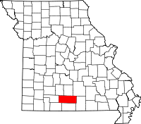 | |
| Townships |
| |
| Unincorporated communities | ||
| Ghost towns | ||