Buhler, Kansas
| Buhler, Kansas | |
|---|---|
| City | |
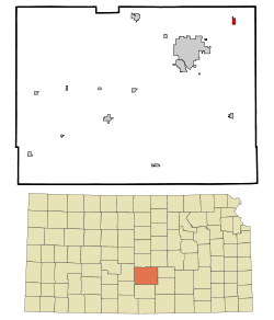 Location within Reno County and Kansas | |
 KDOT map of Reno County (legend) | |
| Coordinates: 38°8′17″N 97°46′22″W / 38.13806°N 97.77278°WCoordinates: 38°8′17″N 97°46′22″W / 38.13806°N 97.77278°W | |
| Country | United States |
| State | Kansas |
| County | Reno |
| Founded | 1888 |
| Government | |
| • Type | Mayor–Council |
| • Mayor | Daniel Friesen [1][2] |
| • City Clerk | Merrill Peterson [1] |
| Area[3] | |
| • Total | 0.72 sq mi (1.86 km2) |
| • Land | 0.72 sq mi (1.86 km2) |
| • Water | 0 sq mi (0 km2) |
| Elevation | 1,476 ft (450 m) |
| Population (2010)[4] | |
| • Total | 1,327 |
| • Estimate (2015)[5] | 1,332 |
| • Density | 1,800/sq mi (710/km2) |
| Time zone | CST (UTC-6) |
| • Summer (DST) | CDT (UTC-5) |
| ZIP code | 67522 |
| Area code | 620 |
| FIPS code | 20-09200 [6] |
| GNIS ID | 0477731 [7] |
| Website |
BuhlerKS |
Buhler is a city in Reno County, Kansas, United States. As of the 2010 census, the city population was 1,327.[8]
History
The first post office in Buhler was established in 1888.[9]
Buhler was primarily inhabited by Mennonite families that had emigrated from Russia during the 1880s.
In September 2012, the City of Buhler received a letter from the Freedom from Religion Foundation regarding a complaint about perceived constitutual violations about the city seal having a cross in it.[10] In November 2012, the city stated that every legal opinion we received indicated the city has no supportable case in the event the it was sued to legally force us to remove the seal and sign. If the city lost, it would be obligated to pay all the legal fees of the prevailing party. The city decided to hold a contest in January 2013 to redesign the city seal without specific reference to religion.[11][12][13][14]
Geography
Buhler is located at 38°8′17″N 97°46′22″W / 38.13806°N 97.77278°W (38.138147, -97.772891).[15] According to the United States Census Bureau, the city has a total area of 0.72 square miles (1.86 km2), all of it land.[3]
Demographics
| Historical population | |||
|---|---|---|---|
| Census | Pop. | %± | |
| 1920 | 486 | — | |
| 1930 | 520 | 7.0% | |
| 1940 | 634 | 21.9% | |
| 1950 | 750 | 18.3% | |
| 1960 | 888 | 18.4% | |
| 1970 | 1,019 | 14.8% | |
| 1980 | 1,188 | 16.6% | |
| 1990 | 1,277 | 7.5% | |
| 2000 | 1,358 | 6.3% | |
| 2010 | 1,327 | −2.3% | |
| Est. 2015 | 1,332 | [5] | 0.4% |
| U.S. Decennial Census | |||
2010 census
As of the census[4] of 2010, there were 1,327 people, 483 households, and 361 families residing in the city. The population density was 1,843.1 inhabitants per square mile (711.6/km2). There were 520 housing units at an average density of 722.2 per square mile (278.8/km2). The racial makeup of the city was 98.1% White, 0.1% African American, 0.7% Native American, 0.1% Pacific Islander, 0.5% from other races, and 0.6% from two or more races. Hispanic or Latino of any race were 2.4% of the population.
There were 483 households of which 36.0% had children under the age of 18 living with them, 63.1% were married couples living together, 9.3% had a female householder with no husband present, 2.3% had a male householder with no wife present, and 25.3% were non-families. 23.6% of all households were made up of individuals and 13% had someone living alone who was 65 years of age or older. The average household size was 2.57 and the average family size was 3.03.
The median age in the city was 41.1 years. 26.8% of residents were under the age of 18; 6.8% were between the ages of 18 and 24; 20.9% were from 25 to 44; 23.3% were from 45 to 64; and 22.2% were 65 years of age or older. The gender makeup of the city was 47.2% male and 52.8% female.
2000 census
As of the census[6] of 2000, there were 1,358 people, 478 households, and 371 families residing in the city. The population density was 2,312.5 people per square mile (888.7/km²). There were 521 housing units at an average density of 887.2 per square mile (340.9/km²). The racial makeup of the city was 98.45% White, 0.15% African American, 0.29% Native American, 0.07% Asian, 0.37% from other races, and 0.66% from two or more races. Hispanic or Latino of any race were 1.18% of the population.
There were 478 households out of which 38.7% had children under the age of 18 living with them, 70.3% were married couples living together, 5.9% had a female householder with no husband present, and 22.2% were non-families. 20.7% of all households were made up of individuals and 9.8% had someone living alone who was 65 years of age or older. The average household size was 2.69 and the average family size was 3.11.
In the city the population was spread out with 28.6% under the age of 18, 6.3% from 18 to 24, 25.6% from 25 to 44, 18.8% from 45 to 64, and 20.8% who were 65 years of age or older. The median age was 38 years. For every 100 females there were 86.5 males. For every 100 females age 18 and over, there were 85.5 males.
The median income for a household in the city was $44,107, and the median income for a family was $50,598. Males had a median income of $31,976 versus $20,592 for females. The per capita income for the city was $18,278. About 1.1% of families and 1.4% of the population were below the poverty line, including 1.8% of those under age 18 and 2.3% of those age 65 or over.
Government
The Buhler government consists of a mayor and five council members. The council meets the last Tuesday of each month at 7 pm.[1][2]
Education
Primary and secondary education
Buhler is part of Unified School District 313.[16][17] The school district administrative office is located in Buhler. The district has six schools and two are located in Buhler:
See also
Further reading
- Hoffnungsau in Kansas; A.J. Dyck; Mennonite Life; October 1949.
References
- 1 2 3 Buhler - Directory of Public Officials
- 1 2 Buhler - Government
- 1 2 "US Gazetteer files 2010". United States Census Bureau. Archived from the original on 2012-01-24. Retrieved 2012-07-06.
- 1 2 "American FactFinder". United States Census Bureau. Retrieved 2012-07-06.
- 1 2 "Annual Estimates of the Resident Population for Incorporated Places: April 1, 2010 to July 1, 2015". Retrieved July 2, 2016.
- 1 2 "American FactFinder". United States Census Bureau. Archived from the original on 2013-09-11. Retrieved 2008-01-31.
- ↑ "US Board on Geographic Names". United States Geological Survey. 2007-10-25. Retrieved 2008-01-31.
- ↑ "2010 City Population and Housing Occupancy Status". U.S. Census Bureau. Archived from the original on July 21, 2011. Retrieved March 27, 2011.
- ↑ "Kansas Post Offices, 1828-1961". Kansas Historical Society. Retrieved 22 June 2014.
- ↑ Letter to Mayor Of Buhler; Freedom From Religion Foundation; September 14, 2012.
- ↑ Buhler's City Seal; Mayor Daniel Friesen; November 23, 2012.
- ↑ Cross on Buhler signs spur complaint; The Hutchinson News; November 23, 2012.
- ↑ City of Buhler sign must go because of lawsuit threat; KSN tv; November 27, 2012.
- ↑ Buhler decides to seek new city logo; The Wichita-Eagle; November 28, 2012.
- ↑ "US Gazetteer files: 2010, 2000, and 1990". United States Census Bureau. 2011-02-12. Retrieved 2011-04-23.
- ↑ USD 313
- ↑ Kansas School District Boundary Map
External links
| Wikimedia Commons has media related to Buhler, Kansas. |
- City
- Schools
- USD 313, local school district
- Maps
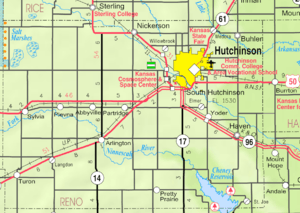
- Buhler City Map, KDOT
Municipalities and communities of Reno County, Kansas, United States | ||
|---|---|---|
| Cities | 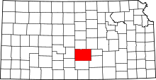 | |
| CDP | ||
| Unincorporated communities | ||
| Ghost towns | ||
| Townships |
| |