Plevna, Kansas
| Plevna, Kansas | |
|---|---|
| City | |
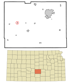 Location within Reno County and Kansas | |
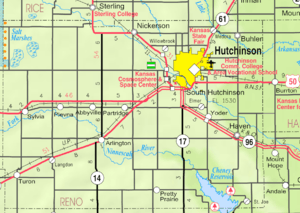 KDOT map of Reno County (legend) | |
| Coordinates: 37°58′20″N 98°18′31″W / 37.97222°N 98.30861°WCoordinates: 37°58′20″N 98°18′31″W / 37.97222°N 98.30861°W[1] | |
| Country | United States |
| State | Kansas |
| County | Reno |
| Area[2] | |
| • Total | 0.23 sq mi (0.60 km2) |
| • Land | 0.23 sq mi (0.60 km2) |
| • Water | 0 sq mi (0 km2) |
| Elevation[1] | 1,690 ft (515 m) |
| Population (2010)[3] | |
| • Total | 98 |
| • Estimate (2015)[4] | 97 |
| • Density | 430/sq mi (160/km2) |
| Time zone | CST (UTC-6) |
| • Summer (DST) | CDT (UTC-5) |
| ZIP code | 67568 |
| Area code | 620 |
| FIPS code | 20-56725 [1] |
| GNIS ID | 0473616 [1] |
Plevna is a city in Reno County, Kansas, United States.[1] As of the 2010 census, the city population was 98.[5]
History
The first post office in Plevna was established in October 1877.[6] It is named after the historical city of Pleven in Bulgaria.[7]
Geography
Plevna is located at 37°58′20″N 98°18′31″W / 37.9722362°N 98.3086791°W (37.9722362, -98.3086791).[1] According to the United States Census Bureau, the city has a total area of 0.23 square miles (0.60 km2), all of it land.[2]
Demographics
| Historical population | |||
|---|---|---|---|
| Census | Pop. | %± | |
| 1920 | 202 | — | |
| 1930 | 174 | −13.9% | |
| 1940 | 161 | −7.5% | |
| 1950 | 200 | 24.2% | |
| 1960 | 117 | −41.5% | |
| 1970 | 124 | 6.0% | |
| 1980 | 115 | −7.3% | |
| 1990 | 117 | 1.7% | |
| 2000 | 99 | −15.4% | |
| 2010 | 98 | −1.0% | |
| Est. 2015 | 97 | [4] | −1.0% |
| U.S. Decennial Census | |||
2010 census
As of the census[3] of 2010, there were 98 people, 43 households, and 29 families residing in the city. The population density was 426.1 inhabitants per square mile (164.5/km2). There were 50 housing units at an average density of 217.4 per square mile (83.9/km2). The racial makeup of the city was 91.8% White, 1.0% Native American, 5.1% from other races, and 2.0% from two or more races. Hispanic or Latino of any race were 6.1% of the population.
There were 43 households of which 23.3% had children under the age of 18 living with them, 39.5% were married couples living together, 18.6% had a female householder with no husband present, 9.3% had a male householder with no wife present, and 32.6% were non-families. 32.6% of all households were made up of individuals and 13.9% had someone living alone who was 65 years of age or older. The average household size was 2.28 and the average family size was 2.83.
The median age in the city was 47 years. 25.5% of residents were under the age of 18; 4% were between the ages of 18 and 24; 19.4% were from 25 to 44; 28.6% were from 45 to 64; and 22.4% were 65 years of age or older. The gender makeup of the city was 43.9% male and 56.1% female.
2000 census
As of the census[8] of 2000, there were 99 people, 46 households, and 28 families residing in the city. The population density was 425.2 people per square mile (166.2/km2). There were 52 housing units at an average density of 223.3 per square mile (87.3/km2). The racial makeup of the city was 96.97% White, and 3.03% from two or more races.
There were 46 households out of which 23.9% had children under the age of 18 living with them, 50.0% were married couples living together, 2.2% had a female householder with no husband present, and 39.1% were non-families. 37.0% of all households were made up of individuals and 19.6% had someone living alone who was 65 years of age or older. The average household size was 2.15 and the average family size was 2.75.
In the city the population was spread out with 22.2% under the age of 18, 6.1% from 18 to 24, 24.2% from 25 to 44, 25.3% from 45 to 64, and 22.2% who were 65 years of age or older. The median age was 44 years. For every 100 females there were 90.4 males. For every 100 females age 18 and over, there were 108.1 males.
The median income for a household in the city was $26,875, and the median income for a family was $33,750. Males had a median income of $20,625 versus $25,417 for females. The per capita income for the city was $14,353. There were no families and 2.8% of the population living below the poverty line, including no under eighteens and none of those over 64.
Notable people
- Karl C. King, U.S. House of Representatives from Pennsylvania
See also
Further reading
References
- 1 2 3 4 5 6 Geographic Names Information System (GNIS) details for Plevna, Kansas; United States Geological Survey (USGS); October 13, 1978.
- 1 2 "US Gazetteer files 2010". United States Census Bureau. Retrieved 2012-07-06.
- 1 2 "American FactFinder". United States Census Bureau. Retrieved 2012-07-06.
- 1 2 "Annual Estimates of the Resident Population for Incorporated Places: April 1, 2010 to July 1, 2015". Retrieved July 2, 2016.
- ↑ "2010 City Population and Housing Occupancy Status". U.S. Census Bureau. Retrieved March 27, 2011.
- ↑ "Kansas Post Offices, 1828-1961, page 2". Kansas Historical Society. Retrieved 22 June 2014.
- ↑ Capace, Nancy (1 June 2000). Encyclopedia of Kansas. North American Book Dist LLC. p. 254. ISBN 978-0-403-09312-0.
- ↑ "American FactFinder". United States Census Bureau. Retrieved 2008-01-31.
External links
| Wikimedia Commons has media related to Plevna, Kansas. |
- City
- Schools
- USD 310, local school district
- Maps
- Plevna City Map, KDOT
Municipalities and communities of Reno County, Kansas, United States | ||
|---|---|---|
| Cities | 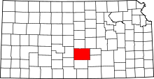 | |
| CDP | ||
| Unincorporated communities | ||
| Ghost towns | ||
| Townships |
| |