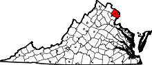
Burke, Virginia
| Burke, Virginia | |
|---|---|
| Census-designated place | |
|
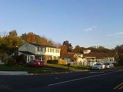
Houses in Burke, October, 2015 | |
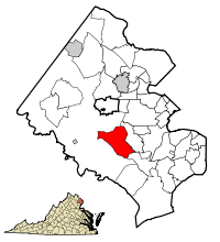 Location of Burke in Fairfax County, Virginia | |
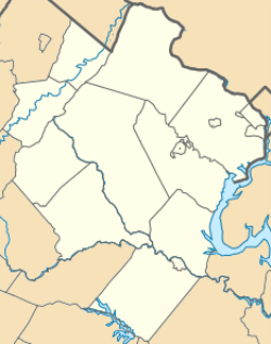 Burke, Virginia  Burke, Virginia  Burke, Virginia Location of Burke in Fairfax County, Virginia | |
| Coordinates: 38°46′53″N 77°16′15″W / 38.78139°N 77.27083°WCoordinates: 38°46′53″N 77°16′15″W / 38.78139°N 77.27083°W | |
| Country |
|
| State |
|
| County |
|
| Area | |
| • Total | 8.7 sq mi (22.6 km2) |
| • Land | 8.6 sq mi (22.3 km2) |
| • Water | 0.1 sq mi (0.3 km2) |
| Elevation | 256 ft (78 m) |
| Population (2010) | |
| • Total | 41,055 |
| • Density | 4,771/sq mi (1,842.1/km2) |
| Time zone | Eastern (EST) (UTC-5) |
| • Summer (DST) | EDT (UTC-4) |
| ZIP codes | 22009, 22015 |
| Area code(s) | 703, 571 |
| FIPS code | 51-11464[1] |
| GNIS feature ID | 1494192[2] |
Burke is a census-designated place (CDP) in Fairfax County, Virginia, United States. As of the 2000 census, Burke had a total population of 57,737. Before 2010, the CDP was divided, with a portion of it becoming Burke Centre CDP; the population remaining in the Burke CDP was reported at 41,055 in the 2010 census.[3]
History
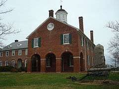
The area of Fairfax County known as Burke is named for Silas Burke (1796–1854), a 19th-century farmer, merchant, and local politician who built a house on a hill overlooking the valley of Pohick Creek in approximately 1824. The house is still standing.[4] When the Orange and Alexandria Railroad was constructed in the late 1840s, the railroad station at the base of that hill was named "Burke's Station" after Burke, who owned the land in the area and donated a right-of-way to the railroad company. The community that grew up around the railroad station acquired a post office branch in 1852. Currently, railroad tracks on the same historical line are owned by the Norfolk Southern Railway and form part of the Manassas line of the Virginia Railway Express commuter rail system, of which two stations lie in the Burke area. The original Burke Station building can still be seen in the community, turned 90 degrees from its historical footprint.[5]
During the Civil War, the railway station was garrisoned by Union troops. The Bog Wallow Ambush occurred in the vicinity in 1861.[6] On December 28, 1862, Confederate cavalry under General J.E.B. Stuart raided the station. Stuart seized supplies from the area, destroyed a nearby bridge, monitored Union messages passing over the telegraph lines, and then famously sent a telegram to Union Quartermaster General Montgomery C. Meigs complaining of the poor quality of the mules he had captured.[5][7] Further action was seen in the neighborhood in 1863.[8]
In 1903, the name of the post office was changed from Burke's Station to "Burke" by Henry C. Copperthite, who bought the Burke House and 241 acres (98 ha) to build a racetrack for trotting and pacing horses. Copperthite was the largest non-governmental employer in Washington, D.C., and he was the "King of Pie". In 1914 his factory in Georgetown was turning out 50,000 pies a day. He built four hotels, stables, and expanded the general store in Burke. Burke soon became a summer getaway from the city's heat for people from all walks of life who came to the Copperthite track and to Burke to attend fairs, see horse races, foot races, motorcycle races, exhibition boxing and baseball games. There were special trains that ran from Union Station in D.C., Alexandria, Prince William and Loudoun counties and as far away as Richmond. Copperthite installed the first phones in Burke, and his stables housed the horses of President McKinley and Vice President Theodore Roosevelt. The site of the racetrack was marked by a historic marker erected by Fairfax County in 2016.[9][10]
The area remained predominantly rural well into the mid-20th century. After World War I, some employees of the federal government began moving into the area, and commuted to Washington by train.
In 1951, the U.S. Civil Aeronautics Administration announced plans to condemn 4,520 acres (1,830 ha) of land in Burke to construct a second airport to serve the Washington metropolitan area.[11] After a lengthy lobbying campaign by area residents, the government in 1958 selected a site near Chantilly, Virginia, which is now Washington Dulles International Airport, instead of Burke. This parcel of land was later developed into what is now referred to as Burke Centre.
The first large subdivision in the vicinity, Kings Park, was constructed beginning in 1960, and was followed by many others over the next two decades, converting Burke into a densely populated suburban community.
A historic marker in Burke denotes the Huldah Coffer House, owned by a prominent resident of the county for many years.[12] Another, privately erected, notes the site of the former Lee Chapel Methodist church, which was purposely burned in 1951 after having been abandoned for some years, but whose cemetery remains on the site.[13]
Geography and climate

Burke is located south of the center of Fairfax County at 38°46′53″N 77°16′15″W / 38.78139°N 77.27083°W (38.781480, −77.270750).[14] It is bordered by the CDPs of Burke Centre to the west, Kings Park West to the northwest, Long Branch and Wakefield to the north, Kings Park to the northeast, West Springfield to the east, Newington Forest to the south, and South Run to the southwest. Burke Lake Park, not part of any CDP, also borders Burke to the southwest. It is a large recreational park operated by the Fairfax County Park Authority, featuring a golf course and woodland surrounding Burke Lake.
According to the United States Census Bureau, the Burke CDP has a total area of 8.7 square miles (22.6 km2), of which 8.6 square miles (22.3 km2) is land and 0.1 square miles (0.3 km2), or 1.22%, is water.[3] Most of the water making up Burke consists of artificial ponds and lakes.
| Climate data for Burke | |||||||||||||
|---|---|---|---|---|---|---|---|---|---|---|---|---|---|
| Month | Jan | Feb | Mar | Apr | May | Jun | Jul | Aug | Sep | Oct | Nov | Dec | Year |
| Average high °F (°C) | 44 (7) |
49 (9) |
58 (14) |
69 (21) |
78 (26) |
85 (29) |
89 (32) |
87 (31) |
81 (27) |
70 (21) |
59 (15) |
48 (9) |
68.1 (20.1) |
| Average low °F (°C) | 24 (−4) |
26 (−3) |
33 (1) |
42 (6) |
52 (11) |
61 (16) |
66 (19) |
65 (18) |
58 (14) |
45 (7) |
36 (2) |
28 (−2) |
44.7 (7.1) |
| Average precipitation inches (mm) | 3.48 (88.4) |
3.01 (76.5) |
4.13 (104.9) |
3.54 (89.9) |
4.42 (112.3) |
3.69 (93.7) |
4.26 (108.2) |
3.98 (101.1) |
4.30 (109.2) |
3.48 (88.4) |
3.41 (86.6) |
3.41 (86.6) |
45.11 (1,145.8) |
| Source: Weather.com[15] | |||||||||||||
Demographics
| Historical population | |||
|---|---|---|---|
| Census | Pop. | %± | |
| 1980 | 33,835 | — | |
| 1990 | 57,734 | 70.6% | |
| 2000 | 57,737 | 0.0% | |
| 2010 | 41,055 | −28.9% | |
As of the census[1] of 2000, there were 57,737 people, 19,215 households, and 15,756 families residing in the community. Burke is the largest community in Virginia recognized by the Census Bureau, other than counties and incorporated cities (although 11 cities and Arlington, Virginia have greater populations). The population density was 5,008.0 people per square mile (1,933.4/km²). There were 19,367 housing units at an average density of 1,679.9/sq mi (648.5/km²). The racial makeup of the CDP was 74.36% White, 14.66% Asian, 5.04% African American, 3.27% from two or more races, 0.21% Native American, 0.08% Pacific Islander, and 2.37% from other races. Hispanic or Latino of any race were 7.43% of the population.
There were 19,215 households out of which 44.0% had children under the age of 18 living with them, 70.6% were married couples living together, 8.7% had a female householder with no husband present, and 18.0% were non-families. 13.4% of all households were made up of individuals and 2.9% had someone living alone who was 65 years of age or older. The average household size was 2.99 and the average family size was 3.30.
The population distribution by age is 27.9% under the age of 18, 7.3% from 18 to 24, 28.6% from 25 to 44, 30.6% from 45 to 64, and 5.5% who were 65 years of age or older. The median age was 38 years. For every 100 females there were 95.1 males. For every 100 females age 18 and over, there were 91.1 males.
According to a 2007 estimate, the median income for a household in Burke is $113,034, and the median income for a family was $125,905. Males had a median income of $66,149 versus $41,933 for females. The per capita income for the CDP was $34,936. About 1.5% of families and 2.3% of the population were below the poverty line, including 2.4% of those under age 18 and 6.0% of those age 65 or over.
Education
Primary and secondary schools
Elementary and secondary school students in Burke are served by the Fairfax County Public School System. The elementary schools in Burke are White Oaks, Terra Centre, Fairview and Cherry Run, although students also attend Ravensworth and Kings Park/Kings Glen. Burke is home to Lake Braddock Secondary School, though many students within the district attend Robinson Secondary School and West Springfield High School, as well as South County Secondary School.
Public libraries
Fairfax County Public Library operates the Pohick Regional Library, the Burke Centre Library, and the Kings Park Library in the CDP.[16][17]
Transportation
Burke is served by two Virginia Railway Express stations, Burke Centre (VRE station) and Rolling Road (VRE station), both on the Manassas line. It is also served by the Metrobus (Washington, D.C.) system, via the 17A, B, G, H, K, and L and the 18G, H, J, P, R, and S routes, with rush hour only service to the Pentagon and Springfield Metro stations.
Recreation and events
Recreation
Along the boundaries of adjoining Fairfax Station, Burke Lake Park is an 888-acre (3.59 km2) park centered on a 218-acre (0.88 km2) recreational lake. The park contains a 4.5-mile (7.2 km) jogging trail, campsites, numerous picnic and sports areas, an 18-hole par three golf course with driving range, a disc golf course, miniature golf course, boat rental, amphitheater, ice cream parlor, carousel, and miniature train ride.
Events
- From May through October, the Burke Farmers Market is in the VRE parking garage every Saturday morning.
- Burke Centre hosts a fall festival for two days every September.
- Burke Nursery & Garden Center hosts a Pumpkin Playground every October.
Communities
Burke Centre is a 1,700-acre (690 ha) planned community that was formerly part of the Burke CDP but is now a separate census-designated area. It is located west of Burke and is divided into five subcommunities: The Commons, The Landings, The Oaks, The Ponds and The Woods. Other notable communities in the Burke area include Rolling Valley West, Burke Village I & II, Lakepointe, Longwood Knolls, Burke Lake Meadows, Edgewater, Lake Braddock, Signal Hill, Crownleigh, and Cherry Run along with Burke Station Square.
Nearby towns, communities, etc.
All distances are by road from Burke Station, the original settlement of Burke:
- Annandale (5 miles NE)
- Clifton (8 miles W)
- Fairfax (5 miles NW)
- Lorton (9 miles SE)
- Springfield (6 miles E)
Notable people
- Retesh Bhalla, aka Sonjay Dutt, professional wrestler
- Hubert Davis, former professional basketball player
- Chad Dukes, Washington-area radio personality
- Tiffany Dupont, actress
- Greg Eklund, drummer for Everclear
- Mia Hamm, American women's soccer player, attended Lake Braddock Secondary School in Burke
- Allen Johnson, gold medalist in 1996 Olympics in Atlanta (110 metre hurdles) and a four-time world champion; attended Lake Braddock Secondary School
- Nguyễn Ngọc Loan, subject of an iconic Vietnam-era picture by Eddie Adams, resided in Burke until his death in 1998.
- David W. Marsden, Virginia state senator
- Ryan Newell, lead guitarist in Sister Hazel
- Rick Renzi, former member of the U.S. House of Representatives
- Byron Saxton, professional wrestler
- Mary Simpson, violinist
- Timothy L. Smith, historian and educator
- Joseph Sobran, journalist and writer for the National Review
- Justin Spring, Olympic medal-winning gymnast
References
- 1 2 "American FactFinder". United States Census Bureau. Archived from the original on 2013-09-11. Retrieved 2008-01-31.
- ↑ "US Board on Geographic Names". United States Geological Survey. 2007-10-25. Retrieved 2008-01-31.
- 1 2 "Geographic Identifiers: 2010 Demographic Profile Data (G001): Burke CDP, Virginia". U.S. Census Bureau, American Factfinder. Retrieved September 22, 2016.
- ↑ "Silas Burke House Historical Marker". Retrieved 2 November 2016.
- 1 2 "Burke Station Historical Marker". Retrieved 2 November 2016.
- ↑ "Bog Wallow Ambush Historical Marker". Retrieved 2 November 2016.
- ↑ "Burke's Station Historical Marker". Retrieved 2 November 2016.
- ↑ "Burke's Station Historical Marker". Retrieved 2 November 2016.
- ↑ "Burke, Mount Vernon: Copperthite Race Track Receives Historical Marker". Retrieved 2 November 2016.
- ↑ MSH. "The Historic Marker at Burke Nursery". Retrieved 2 November 2016.
- ↑ Winship, Thomas (14 June 1951). "450-Acre Tract in Fairfax County Located West of Shirley Hwy.: Burke, Va. Selected As Site of Airport". The Washington Post. Retrieved 28 April 2016 – via Proquest. (subscription required (help)).
- ↑ "The Huldah Coffer House Historical Marker". Retrieved 2 November 2016.
- ↑ "Lee Chapel Church Historical Marker". Retrieved 2 November 2016.
- ↑ "US Gazetteer files: 2010, 2000, and 1990". United States Census Bureau. 2011-02-12. Retrieved 2011-04-23.
- ↑ "Average Weather for Burke, VA". The Weather Channel. Retrieved July 14, 2010.
- ↑ "Library Branches." Fairfax County Public Library. Retrieved on October 21, 2009.
- ↑ "Burke CDP, Virginia." U.S. Census Bureau. Retrieved on October 21, 2009.
- Netherton, Nan & Rose, Ruth Preston (1988). Memories of Beautiful Burke, Virginia. Burke: Burke Historical Society. ISBN 0-9620619-0-5.
External links
| Wikivoyage has a travel guide for Burke (Virginia). |
 |
Fairfax | Annandale | | |
| Clifton | |
Springfield | ||
| ||||
| | ||||
| Lorton |
| Administration |  | ||||||||||
|---|---|---|---|---|---|---|---|---|---|---|---|
| Organizations | |||||||||||
| Landmarks | |||||||||||
| Transportation |
| ||||||||||
| Culture |
| ||||||||||
| Education | |||||||||||