Canaan, Vermont
| Canaan, Vermont | |
|---|---|
| Town | |
 | |
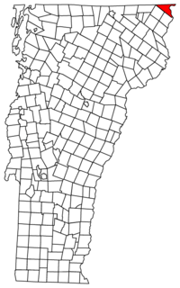 Located in Essex County, Vermont | |
 Location of Vermont in the United States | |
| Coordinates: 44°59′N 71°33′W / 44.983°N 71.550°WCoordinates: 44°59′N 71°33′W / 44.983°N 71.550°W | |
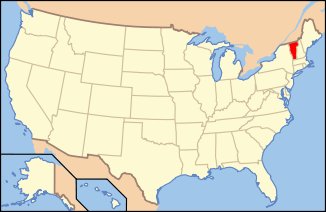
| Country | United States |
| State | Vermont |
| County | Essex |
| Area | |
| • Total | 33.4 sq mi (86.6 km2) |
| • Land | 33.0 sq mi (85.5 km2) |
| • Water | 0.4 sq mi (1.1 km2) |
| Elevation | 1,355 ft (413 m) |
| Population (2010) | |
| • Total | 972 |
| • Density | 30/sq mi (11.4/km2) |
| Time zone | EST (UTC-5) |
| • Summer (DST) | EDT (UTC-4) |
| ZIP codes | 05902, 05903 |
| Area code(s) | 802 |
| FIPS code | 50-11800[1] |
| GNIS feature ID | 1462064[2] |
| Website |
www |
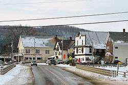
Canaan is a town in Essex County, Vermont, United States. The population was 972 at the 2010 census,[3] down from 1,078 at the 2000 census. Canaan contains the village of Beecher Falls, located at the confluence of the Connecticut River and Halls Stream. It is part of the Berlin, NH–VT Micropolitan Statistical Area.
Geography
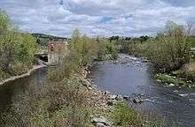
Canaan is the northeasternmost town in Vermont, bordered by the Canadian province of Quebec to the north and the U.S. state of New Hampshire to the east. It is one of two towns in Vermont to share a border with both another state and Canada, the other such town being Alburgh in the northwestern corner. Canaan is also the only town in Vermont to share a land border with New Hampshire - the town's far northeastern corner touches the southwestern corner of the town of Pittsburg - as the Connecticut River defines the state line from Canaan southward.
According to the United States Census Bureau, the town has a total area of 33.4 square miles (86.6 km2), of which 33.0 square miles (85.5 km2) is land and 0.42 square miles (1.1 km2), or 1.24%, is water.[3]
Demographics
| Historical population | |||
|---|---|---|---|
| Census | Pop. | %± | |
| 1790 | 19 | — | |
| 1800 | 45 | 136.8% | |
| 1810 | 332 | 637.8% | |
| 1820 | 227 | −31.6% | |
| 1830 | 373 | 64.3% | |
| 1840 | 378 | 1.3% | |
| 1850 | 471 | 24.6% | |
| 1860 | 408 | −13.4% | |
| 1870 | 419 | 2.7% | |
| 1880 | 637 | 52.0% | |
| 1890 | 829 | 30.1% | |
| 1900 | 934 | 12.7% | |
| 1910 | 869 | −7.0% | |
| 1920 | 982 | 13.0% | |
| 1930 | 906 | −7.7% | |
| 1940 | 872 | −3.8% | |
| 1950 | 969 | 11.1% | |
| 1960 | 1,094 | 12.9% | |
| 1970 | 949 | −13.3% | |
| 1980 | 1,196 | 26.0% | |
| 1990 | 1,121 | −6.3% | |
| 2000 | 1,078 | −3.8% | |
| 2010 | 972 | −9.8% | |
| Est. 2014 | 934 | [4] | −3.9% |
| U.S. Decennial Census[5] | |||
As of the census[1] of 2000, there were 1,078 people, 441 households, and 306 families residing in the town. The population density was 32.5 people per square mile (12.5/km2). There were 650 housing units at an average density of 19.6 per square mile (7.6/km2). The racial makeup of the town was 95.83% White, 0.19% African American, 0.83% Native American, 0.09% Asian, and 3.06% from two or more races. Hispanic or Latino of any race were 0.28% of the population.
There were 441 households out of which 33.6% had children under the age of 18 living with them, 55.1% were married couples living together, 8.6% had a female householder with no husband present, and 30.4% were non-families. 26.8% of all households were made up of individuals and 11.1% had someone living alone who was 65 years of age or older. The average household size was 2.44 and the average family size was 2.94.
In the town the population was spread out with 26.9% under the age of 18, 6.2% from 18 to 24, 27.6% from 25 to 44, 25.4% from 45 to 64, and 13.8% who were 65 years of age or older. The median age was 39 years. For every 100 females there were 100.0 males. For every 100 females age 18 and over, there were 97.5 males.
The median income for a household in the town was $32,574, and the median income for a family was $36,705. Males had a median income of $28,913 versus $21,544 for females. The per capita income for the town was $14,131. About 10.2% of families and 14.3% of the population were below the poverty line, including 16.7% of those under age 18 and 18.7% of those age 65 or over.
Government
Social services
Social services are provided in part by the Northeast Kingdom Community Action, located here and in other Northeast Kingdom sites.
Northeast Kingdom Learning Services provides Adult Education and Literacy and High School Completion services to Canaan at no charge.
See also
References
- 1 2 "American FactFinder". United States Census Bureau. Archived from the original on 2013-09-11. Retrieved 2008-01-31.
- ↑ "US Board on Geographic Names". United States Geological Survey. 2007-10-25. Retrieved 2008-01-31.
- 1 2 "Geographic Identifiers: 2010 Census Summary File 1 (G001): Canaan town, Essex County, Vermont". American Factfinder. U.S. Census Bureau. Retrieved March 31, 2016.
- ↑ "Annual Estimates of the Resident Population for Incorporated Places: April 1, 2010 to July 1, 2014". Retrieved June 4, 2015.
- ↑ "U.S. Decennial Census". United States Census Bureau. Archived from the original on May 11, 2015. Retrieved May 16, 2015.
External links
| Wikimedia Commons has media related to Canaan, Vermont. |
Municipalities and communities of Essex County, Vermont, United States | ||
|---|---|---|
| Towns | 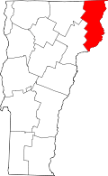 | |
| CDPs | ||
| Grants and gores | ||
| Footnotes | ‡ Unorganized | |