Victory, Vermont
| Victory, Vermont | |
|---|---|
| Town | |
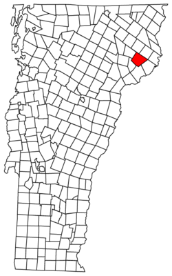 Located in Essex County, Vermont | |
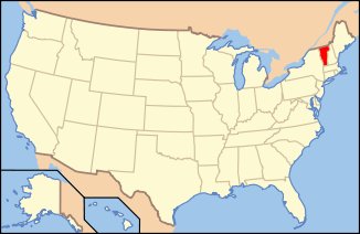 Location of Vermont with the U.S.A. | |
| Coordinates: 44°32′8″N 71°49′50″W / 44.53556°N 71.83056°WCoordinates: 44°32′8″N 71°49′50″W / 44.53556°N 71.83056°W | |
| Country | United States |
| State | Vermont |
| County | Essex |
| Government | |
| • Type | Unincorporated Town |
| Area | |
| • Total | 43.0 sq mi (111.4 km2) |
| • Land | 43.0 sq mi (111.3 km2) |
| • Water | 0.0 sq mi (0.1 km2) |
| Elevation | 1,247 ft (380 m) |
| Population (2010) | |
| • Total | 62 |
| • Density | 1.4/sq mi (0.56/km2) |
| • Households | 36 |
| • Families | 12 |
| Time zone | EST (UTC-5) |
| • Summer (DST) | EDT (UTC-4) |
| ZIP code | 05858 |
| Area code(s) | 802 |
| FIPS code | 50-75175[1] |
| GNIS feature ID | 1462236[2] |
Victory is a town in Essex County, Vermont, United States. The population was 62 at the 2010 census.[3] It is part of the Berlin, NH–VT Micropolitan Statistical Area. Victory was one of the last two towns in Vermont to be linked to the electric grid, in 1963. [4]
Geography
According to the United States Census Bureau, the town has a total area of 43.0 square miles (111.4 km2), of which 43.0 square miles (111.3 km2) is land and 0.04 square mile (0.1 km2) (0.07%) is water.
Demographics
| Historical population | |||
|---|---|---|---|
| Census | Pop. | %± | |
| 1810 | 6 | — | |
| 1830 | 53 | — | |
| 1840 | 140 | 164.2% | |
| 1850 | 168 | 20.0% | |
| 1860 | 212 | 26.2% | |
| 1870 | 263 | 24.1% | |
| 1880 | 321 | 22.1% | |
| 1890 | 564 | 75.7% | |
| 1900 | 321 | −43.1% | |
| 1910 | 206 | −35.8% | |
| 1920 | 125 | −39.3% | |
| 1930 | 80 | −36.0% | |
| 1940 | 104 | 30.0% | |
| 1950 | 49 | −52.9% | |
| 1960 | 46 | −6.1% | |
| 1970 | 42 | −8.7% | |
| 1980 | 56 | 33.3% | |
| 1990 | 50 | −10.7% | |
| 2000 | 97 | 94.0% | |
| 2010 | 62 | −36.1% | |
| Est. 2014 | 60 | [5] | −3.2% |
| U.S. Decennial Census[6] | |||
As of the census[1] of 2000, there were 97 people, 45 households, and 27 families residing in the town. The population density was 2.3 people per square mile (0.9/km2). There were 90 housing units at an average density of 2.1 per square mile (0.8/km2). The racial makeup of the town was 97.94% White, 1.03% from other races, and 1.03% from two or more races. Hispanic or Latino of any race were 1.03% of the population.
There were 45 households out of which 17.8% had children under the age of 18 living with them, 53.3% were married couples living together, 6.7% had a female householder with no husband present, and 40.0% were non-families. 26.7% of all households were made up of individuals and 11.1% had someone living alone who was 65 years of age or older. The average household size was 2.16 and the average family size was 2.67.
In the town the population was spread out with 17.5% under the age of 18, 4.1% from 18 to 24, 24.7% from 25 to 44, 35.1% from 45 to 64, and 18.6% who were 65 years of age or older. The median age was 46 years. For every 100 females there were 115.6 males. For every 100 females age 18 and over, there were 128.6 males.
The median income for a household in the town was $28,750, and the median income for a family was $38,333. Males had a median income of $28,750 versus $30,000 for females. The per capita income for the town was $18,558. There were 6.7% of families and 13.2% of the population living below the poverty line, including 21.1% of under eighteens and none of those over 64.
 |
Burke | East Haven | Granby | |
| Kirby | |
Guildhall | ||
| ||||
| | ||||
| Kirby | Concord | Lunenburg |
References
- 1 2 "American FactFinder". United States Census Bureau. Retrieved 2008-01-31.
- ↑ "US Board on Geographic Names". United States Geological Survey. 2007-10-25. Retrieved 2008-01-31.
- ↑ "Profile of General Population and Housing Characteristics: 2010 Demographic Profile Data (DP-1): Victory town, Essex County, Vermont". U.S. Census Bureau, American Factfinder. Retrieved February 3, 2012.
- ↑ Vermont Public Service Department (1998), "Comprehensive Energy Plan", State of Vermont, p. 23 http://publicservice.vermont.gov/publications/energy_plan/1998_plan, retrieved April 25, 2014 Missing or empty
|title=(help) - ↑ "Annual Estimates of the Resident Population for Incorporated Places: April 1, 2010 to July 1, 2014". Retrieved June 4, 2015.
- ↑ "U.S. Decennial Census". United States Census Bureau. Retrieved May 16, 2015.
External links
Municipalities and communities of Essex County, Vermont, United States | ||
|---|---|---|
| Towns | 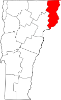 | |
| CDPs | ||
| Grants and gores | ||
| Footnotes | ‡ Unorganized | |