Lemington, Vermont
| Lemington, Vermont | |
|---|---|
| Town | |
 Located in Essex County, Vermont | |
 Location of Vermont in the United States | |
| Coordinates: 44°55′26″N 71°33′25″W / 44.92389°N 71.55694°WCoordinates: 44°55′26″N 71°33′25″W / 44.92389°N 71.55694°W | |
| Country | United States |
| State | Vermont |
| County | Essex |
| Chartered | 1762 |
| Settled | 1789 |
| Organized | 1796 |
| Area | |
| • Total | 35.5 sq mi (92.0 km2) |
| • Land | 35.4 sq mi (91.6 km2) |
| • Water | 0.2 sq mi (0.4 km2) |
| Elevation | 2,070 ft (631 m) |
| Population (2010) | |
| • Total | 104 |
| • Density | 3/sq mi (1.1/km2) |
| Time zone | EST (UTC-5) |
| • Summer (DST) | EDT (UTC-4) |
| ZIP codes | 05903, 05905 |
| Area code(s) | 802 |
| FIPS code | 50-39700[1] |
| GNIS feature ID | 1462133[2] |
Lemington is a town in Essex County, Vermont, United States. The population was 104 as of the 2010 census.[3] It is part of the Berlin, NH–VT Micropolitan Statistical Area.
Geography
Lemington is in northeastern Essex County along the Connecticut River, the border between Vermont and New Hampshire. The town is bordered to the southwest by Bloomfield, at its westernmost point by Lewis, to the northwest by Averill, and to the northeast by Canaan, all in Vermont. To the southeast, across the Connecticut, are the towns of Colebrook and Columbia, New Hampshire. Vermont Route 102 runs from south to north along the eastern edge of the town, following the Connecticut. Route 26 leads east across the Connecticut into Colebrook village. The villages of Lemington and Columbia are connected by the covered Columbia Bridge across the Connecticut.
According to the United States Census Bureau, the town of Lemington has a total area of 35.5 square miles (92.0 km2), of which 35.4 square miles (91.6 km2) is land and 0.2 square miles (0.4 km2), or 0.41%, is water.[3] The town's highest point is 3,148-foot (960 m) Monadnock Mountain, in the eastern part of town overlooking the Connecticut.
Demographics
| Historical population | |||
|---|---|---|---|
| Census | Pop. | %± | |
| 1790 | 31 | — | |
| 1800 | 52 | 67.7% | |
| 1810 | 132 | 153.8% | |
| 1820 | 139 | 5.3% | |
| 1830 | 183 | 31.7% | |
| 1840 | 124 | −32.2% | |
| 1850 | 187 | 50.8% | |
| 1860 | 207 | 10.7% | |
| 1870 | 191 | −7.7% | |
| 1880 | 222 | 16.2% | |
| 1890 | 227 | 2.3% | |
| 1900 | 204 | −10.1% | |
| 1910 | 138 | −32.4% | |
| 1920 | 145 | 5.1% | |
| 1930 | 133 | −8.3% | |
| 1940 | 131 | −1.5% | |
| 1950 | 105 | −19.8% | |
| 1960 | 112 | 6.7% | |
| 1970 | 120 | 7.1% | |
| 1980 | 108 | −10.0% | |
| 1990 | 102 | −5.6% | |
| 2000 | 107 | 4.9% | |
| 2010 | 104 | −2.8% | |
| Est. 2014 | 101 | [4] | −2.9% |
| U.S. Decennial Census[5] | |||
As of the census[1] of 2000, there were 107 people, 49 households, and 34 families residing in the town. The population density was 3.0 people per square mile (1.2/km2). There were 77 housing units at an average density of 2.2 per square mile (0.8/km2). The racial makeup of the town was 94.39% White, and 5.61% from two or more races.
There were 49 households out of which 22.4% had children under the age of 18 living with them, 61.2% were married couples living together, 8.2% had a female householder with no husband present, and 30.6% were non-families. 28.6% of all households were made up of individuals and 20.4% had someone living alone who was 65 years of age or older. The average household size was 2.18 and the average family size was 2.68.
In the town the population was spread out with 22.4% under the age of 18, 2.8% from 18 to 24, 20.6% from 25 to 44, 27.1% from 45 to 64, and 27.1% who were 65 years of age or older. The median age was 52 years. For every 100 females there were 118.4 males. For every 100 females age 18 and over, there were 93.0 males.
The median income for a household in the town was $35,417, and the median income for a family was $47,500. Males had a median income of $28,750 versus $24,063 for females. The per capita income for the town was $17,146. There were no families and 1.3% of the population living below the poverty line, including no under eighteens and 5.9% of those over 64.
 |
Averill | Canaan | Canaan | |
| Lewis | |
Colebrook, NH | ||
| ||||
| | ||||
| Bloomfield | Columbia, NH | Columbia, NH |
References
- 1 2 "American FactFinder". United States Census Bureau. Retrieved 2008-01-31.
- ↑ "US Board on Geographic Names". United States Geological Survey. 2007-10-25. Retrieved 2008-01-31.
- 1 2 "Geographic Identifiers: 2010 Census Summary File 1 (G001): Lemington town, Essex County, Vermont". American Factfinder. U.S. Census Bureau. Retrieved April 7, 2016.
- ↑ "Annual Estimates of the Resident Population for Incorporated Places: April 1, 2010 to July 1, 2014". Retrieved June 4, 2015.
- ↑ "U.S. Decennial Census". United States Census Bureau. Retrieved May 16, 2015.
Municipalities and communities of Essex County, Vermont, United States | ||
|---|---|---|
| Towns | 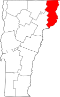 | |
| CDPs | ||
| Grants and gores | ||
| Footnotes | ‡ Unorganized | |