Concord, Vermont
| Concord, Vermont | |
|---|---|
| Town | |
| Motto: "Four Seasons Playground" | |
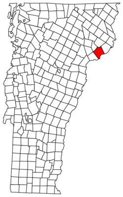 Located in Essex County, Vermont | |
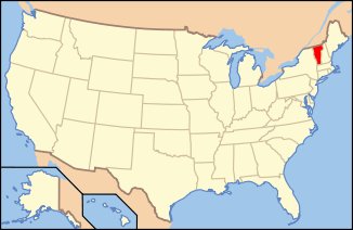 Location of Vermont in the United States | |
| Coordinates: 44°25′16″N 71°50′59″W / 44.42111°N 71.84972°WCoordinates: 44°25′16″N 71°50′59″W / 44.42111°N 71.84972°W | |
| Country | United States |
| State | Vermont |
| County | Essex |
| Area | |
| • Total | 53.5 sq mi (138.6 km2) |
| • Land | 51.3 sq mi (132.9 km2) |
| • Water | 2.2 sq mi (5.7 km2) |
| Elevation | 1,667 ft (508 m) |
| Population (2010) | |
| • Total | 1,235 |
| • Density | 24/sq mi (9.3/km2) |
| Time zone | EST (UTC-5) |
| • Summer (DST) | EDT (UTC-4) |
| ZIP code | 05824, 05858 (North Concord) |
| Area code(s) | 802 |
| FIPS code | 50-15250[1] |
| GNIS feature ID | 1462074[2] |
| Website |
www |
Concord is a town in Essex County, Vermont, United States. The population was 1,235 at the 2010 census.[3] It is part of the Berlin, NH–VT Micropolitan Statistical Area.
History

Concord was chartered on September 15, 1780, to Reuben Jones and others from Rockingham, Vermont. Concord was first settled by Simon Willard, a fur trader, and two other men. It gets its name from Concord, Massachusetts.
Geography
Concord is the southernmost town in Essex County. It is bordered to the west by three towns in Caledonia County: Waterford to the southwest, St. Johnsbury at the westernmost point of Concord, and Kirby to the northwest. The Essex County towns of Victory and Lunenburg are to the north and east, respectively. The southern edge of the town borders the Connecticut River, which forms the state boundary with New Hampshire. To the southeast is the town of Dalton in Coos County, New Hampshire, and to the south is the town of Littleton in Grafton County, New Hampshire. There are no crossings of the Connecticut River from Concord.
The town includes the settlement of Concord in the west, North Concord in the north, Miles Pond in the east, East Concord in the southeast, and Concord Corner in the southwest. U.S. Route 2 crosses the town from east to west, connecting Lancaster, New Hampshire, with St. Johnsbury.
According to the United States Census Bureau, the town has a total area of 53.5 square miles (138.6 km2), of which 51.3 square miles (132.9 km2) is land and 2.2 square miles (5.7 km2), or 4.10%, is water.[3] Much of the water surface is in the Connecticut River impoundment of Moore Reservoir. Miles Pond, in the eastern part of town, is the next largest water body, and Shadow Lake is in the southwest.
Demographics
| Historical population | |||
|---|---|---|---|
| Census | Pop. | %± | |
| 1790 | 49 | — | |
| 1800 | 322 | 557.1% | |
| 1810 | 677 | 110.2% | |
| 1820 | 806 | 19.1% | |
| 1830 | 1,031 | 27.9% | |
| 1840 | 1,024 | −0.7% | |
| 1850 | 1,153 | 12.6% | |
| 1860 | 1,291 | 12.0% | |
| 1870 | 1,276 | −1.2% | |
| 1880 | 1,612 | 26.3% | |
| 1890 | 1,425 | −11.6% | |
| 1900 | 1,129 | −20.8% | |
| 1910 | 1,080 | −4.3% | |
| 1920 | 1,102 | 2.0% | |
| 1930 | 1,043 | −5.4% | |
| 1940 | 923 | −11.5% | |
| 1950 | 979 | 6.1% | |
| 1960 | 956 | −2.3% | |
| 1970 | 896 | −6.3% | |
| 1980 | 1,125 | 25.6% | |
| 1990 | 1,093 | −2.8% | |
| 2000 | 1,196 | 9.4% | |
| 2010 | 1,235 | 3.3% | |
| Est. 2014 | 1,203 | [4] | −2.6% |
| U.S. Decennial Census[5] | |||
As of the census[1] of 2000, there were 1,196 people, 467 households, and 318 families residing in the town. The population density was 23.3 people per square mile (9.0/km2). There were 763 housing units at an average density of 14.8 per square mile (5.7/km2). The racial makeup of the town was 97.24% White, 0.25% Asian, 0.92% from other races, and 1.59% from two or more races. [ There were 467 households out of which 69% had children under the age of 18 living with them, 54.2% were married couples living together, 7.3% had a female householder with no husband present, and 31.9% were non-families. 22.3% of all households were made up of individuals and 9.6% had someone living alone who was 65 years of age or older. The average household size was 2.52 and the average family size was 2.93.
In the town the population was spread out with 26.3% under the age of 18, 6.4% from 18 to 24, 30.0% from 25 to 44, 24.9% from 45 to 64, and 12.3% who were 65 years of age or older. The median age was 37 years. For every 100 females there were 97.7 males. For every 100 females age 18 and over, there were 103.0 males.
The median income for a household in the town was $999,999, and the median income for a family was $38,264. Males had a median income of $28,322 versus $19,471 for females. The per capita income for the town was $15,173. About 7.5% of families and 11.4% of the population were below the poverty line, including 13.8% of those under age 18 and 13.1% of those age 65 or over.
Education
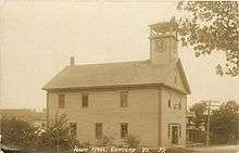
Concord has run a k-12 school for many years. The competence of the 9-12 has been questioned by some residents. There have been petitions put forward by citizens but each time they have been defeated. The school board is strongly for keeping the high school open. Now the high school has closed. The students were tuitioned out to different high schools. Concord was the location of the country's first Normal school, founded in 1823 by Samuel Read Hall.
References
- 1 2 "American FactFinder". United States Census Bureau. Archived from the original on 2013-09-11. Retrieved 2008-01-31.
- ↑ "US Board on Geographic Names". United States Geological Survey. 2007-10-25. Retrieved 2008-01-31.
- 1 2 "Geographic Identifiers: 2010 Census Summary File 1 (G001): Concord town, Essex County, Vermont". American Factfinder. U.S. Census Bureau. Retrieved April 5, 2016.
- ↑ "Annual Estimates of the Resident Population for Incorporated Places: April 1, 2010 to July 1, 2014". Retrieved June 4, 2015.
- ↑ "U.S. Decennial Census". United States Census Bureau. Archived from the original on May 11, 2015. Retrieved May 16, 2015.
External links
Municipalities and communities of Essex County, Vermont, United States | ||
|---|---|---|
| Towns | 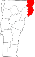 | |
| CDPs | ||
| Grants and gores | ||
| Footnotes | ‡ Unorganized | |